Lowell's Legacy- Part 8 - Acidalia Reimaged
"As, in observations of minute detail, the psychic element insensibly creeps in, it will be well to consider it for a moment. An idea is a force, a mode of motion, which, unless obstructed by other ideas, instantly and inevitably produces its effect upon whatever mind it may chance to impinge, just as light or electricity or any other mode of motion does, according to its kind.
An easy instance of this can be got by asserting at dinner, before a company of connoisseurs, that the wine is slightly corked. Every one not actuated by a spirit of contradiction will at once perceive that it is so, and will continue to believe it, in many cases, after it is abundantly disproved. This is what takes place in the normal, unbiased--that is, so far as this idea goes-- vacant mind. But minds have their familiar ideas, which an incoming idea is pretty sure to rouse, and these react to some extent upon the stranger, and color it with something of their own complexion. If we expect to meet a certain person, an approaching figure will most deceitfully take on his garb. The mere idea of a man walking finds the expectation ready instinctively to endow it with the attributes of our friend. But this may happen truly as well as falsely. The expert sees what the tyro misses, not from better eyesight but from better mechanism in the higher centres. A very slight hint from the eye goes a long way in the brain of the one; no distance at all in the brain of the other. Our senses are our avenues of approach from the outer world. Messages from them are therefore usually and rightly attributed to stimuli from without. But it is possible for these messages to be tampered with at any stage of their journey. It is even possible for them to be started in some other part of the brain, travel down to the lower centres and be sent up from them to the higher ones, indistinguishable from bona fide messages from without."
-Percival Lowell
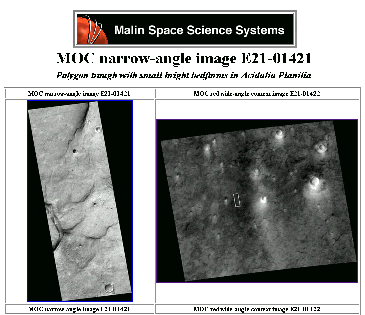
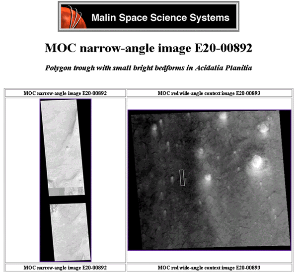
The area at 27 west by 39 north in Acidalia Planitia was successfully re-imaged on September 27th, 2003. MOC image E21-01421 was released on September 30th, 2003. This location was one of the five primary target sites given to NASA for re-imaging as the result of an agreement between NASA and FACETS in 2001.
After several FOIA requests at FACETS behest, research revealed that MSSS was in breach of contract by exceeding the release period for data acquired. After an initial proprietary data period (during which MSSS and JPL have total access) all data must be released into public domain. Upon FACETS announcement that they intended to pursue this issue in open court, NASA graciously agreed to re-image five sites on behalf of the public's interest.
Months after this agreement was reached, FACETS inquired about the delivery of these images and was informed that one image of the "face" at Cydonia had already been acquired and little other detail. After numerous e-mail exchanges NASA finally produced a url to full blown website entitled, "Unmasking the Face", debunking the face using the newest, poorly acquired and processed image. It is critical to note that at the time of this debunking that NASA failed to provide any ancillary data to support their suppositions or allow for independent analysis.
Like good little drones, we are expected to partake of what they regurgitate. Some months later when NASA finally released the ancillary data on the Face, independent researchers (most notably Lan Fleming) were able to refute most of NASA's analysis as spurious and lacking merit. But the damage had been done. Communication between NASA and FACETS dried up. A subsequently lackluster image of the D&M pyramid produced no fanfare and the other three images were forgotten as FACETS quit asking about them. The list of targeting sites can be found at http://www.enterprisemission.com/facets.htm .
The image below does serve to illustrate that NASA is dedicated to keeping it's side of the bargain, though hardly expeditiously. Over three years after submission of the FACETS targeting sites NASA finally acquired this image, E21-01421 at the coordinates of image MOC M04-00291.
No announcements were made. NASA didn't
contact FACETS to inform them of the acquisition. And FACETS never asked NASA
about the images. NASA even changed the nomenclature from "fine channels"
to "polygon trough" so as to not tip anyone off. This image sat on
the Internet for several months before we stumbled upon it in out investigations
of the glass tunnels in Acidalia Planitia. It was unceremoniously released along
with thousands of other images without fanfare or notification. An inequitable
epitaph for such a noble venture undertaken at the behest of the tax paying
American, forgotten along with the politics of the recent past.
http://www.msss.com/moc_gallery/e19_r02/full_gif_non_map/E21/E2101421.gif
http://www.msss.com/moc_gallery/ab1_m04/images/M0400291.html
Special thanks to John Levassuer and SPSR
Lowell's bookie would probably give odds that other primary targeting sites and possibly the secondary sites have been re-imaged as well and are out on the web. NASA certainly isn't commenting on the issue. Rather than proselytizing their position as they did on the Cydonia image, they simply fulfill their obligations unannounced, hoping that time will cure the nagging itch in their britches that FACETS created. They assume, that as with Lowell, time will eventually cause such avenues of inquiry to abandoned due to frustration or demise. Unfortunately for those of such mindset, as additional data is acquired, more anomalies are revealed.
Perhaps seeing this image will spur the lethargic behemoth that FACETS has become into action, causing the organization that NASA rolled over and played dead for to actually once again inquire as to the disposition of the promised images. Such activity could provide the impetus for additional proactive intervention into the direction of Mars research. One can only hope that the FACETS organization can have life breathed back into it. I'm just a member, I'm not the President. I'll do my part plus some if you slackers will come back to the table.
To quote the venerable Peter Gersten esq., "FACETS looks forward to an expanding public participation in the NASA exploration of Mars. "
Let us hope this statement proves correct and FACETS once again rises to rattle the cages at JPL and MSSS. This can only happen if the public participates actively.
As we write this final segment NASA has lost contact with its Spirit rover. We have high hopes that the mission can be salvaged. Since this piece's inception several years ago, we have seen The Mars Climate Orbiter, the Mars Polar Lander, the ESA-British Beagle probe and now our Rover all succumb to the mysteries of Mars. Preceded by the billion dollar loss of the Mars Observer along with failures of successive Russian and Japanese probes. Mars for whatever reason, is palpably more distant for the news. Most folks seem to forget we almost lost the Mars Global Surveyor when one of it's solar panels failed to deploy properly during aerobraking, postponing its primary science mission for almost a year. If not for MGS we would not be debating such volatile issues as raised in this venue. Only your ardent support can raise the level of consciousness to a point at which such matters become tantamount to our existence. If you pay taxes in the United States you have a constitutional privilege to request and direct the thrust of planetary science in regards to these matters of gravest consequence. Likewise, our European colleagues, en masse, can apply appropriate cultural and political pressure to the bodies that control the pointing of their new probe's telemetry. The Europeans, in our opinion, are more amenable to the idea of life on Mars than is the JPL/MSSS consortium. Perhaps some type of disclosure is imminent.
If you find you have passion towards some
issues we urge you to become proactive. There is nothing so empowering as making
the elephant dance. Do your own research. Post a website. Call Art Bell. Write
your congressman. Communicate with others of like disposition.You might even
send an email to FACETS ( contact@InfoSourceResearch.com ) and express your
desire to participate in FACETS activities. It all adds up (or multiplies if
you recall Lowell's analysis from so long ago).
Given that researching Mars is so difficult a task it follows that one would
assume, when attempting to re-image an area of interest, the photographer would
strive to produce a better image than the original to aid in enhancing examination
of the area. Examination of the spacecraft ancillary data shows just the opposite.
Either a unique set of circumstance surrounded the acquisition of this image
or the photographer did his best to get the poorest resolution image possible.
Adding this together with the fact that both MGS and the Mars Odyssey have passed over the Acidalia region regularly, taking multiple images under normal conditions very close to these coordinates seems to indicate that only this particular image from the Acidalia region was imaged under such controllably adverse conditions.
We are faced with only two options, either this was a deliberately sloppy image acquisition or a heroic attempt to garner good will on behalf of public interest under unusually difficult imaging conditions. If an heroic attempt, we'd recommend that NASA hire new PR folks (we know some good ones with aerospace experience who are looking for work) as the news was poorly disseminated.
Possibly, after looking at this second image, our researchers could not reconcile their belief system with what the re-imaging confirmed as a real artifact on Mars. After being beat up with their own ancillary data with regards to the "Face" image, they chose to remain silent and hope FACETS would just go away. Judging from recent inactivity, I'd say MSSS's pragmatic approach suits the situation and will most likely outlast the staying power of the staunchest anomalist. The FACETS activists seem to have lost the zeal which propelled them through the millennium. Those individuals of special conscience who endeavored to step outside of the box have crept inexorably back within its confines.
We will attempt to elucidate on the nuances of these implications gleaned from ancillary data, but in finality the verdict is left to the reader, as NASA's comments on such issues are not forthcoming. Perhaps if pursued by an organization like FACETS, such trivialities would be easily explained and not become the fodder of conspiracists and other Internet entrepreneurs ( keep in mind that this is a labor of love-no remuneration is sought or anticipated). Our interpretations are far removed from those of the individuals who buy bread for their loved ones with salaries derived from such activities. Thus we believe these analyses to be free from bias, at least such bias as is the progeny of avarice. We simply hope to foster a better understanding of the universe we live in and it's infinite possibilities.
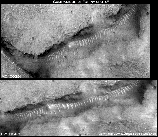
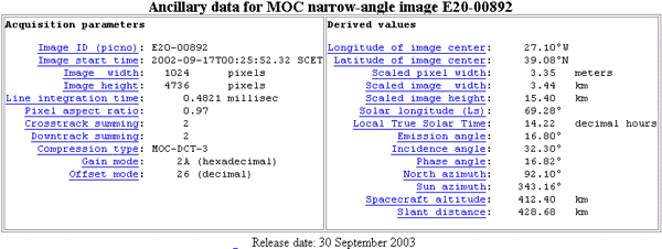
Below we have a comparison of the ancillary data from M04-00291 (May 22, 2000) and MOC image E21-01421 (Sept. 30, 2003).
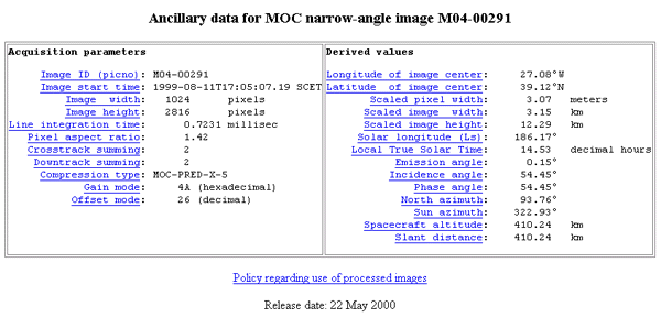
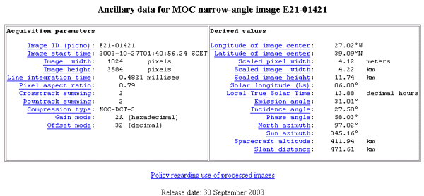
With the limited resources at our disposal, we offer our interpretation of these imaging conditions and some opinion on the dichotomy of the spacecraft's ancillary data.
| M0400291 |
4A
|
Gain mode Exposure of the MOC is limited by the line-time. The MOC is only able to covert this light into, at most, 256 shades of gray (black to white). "Gain" is used to take the actual spread of brightnesses and scale it to 256 levels (8 bits). See the PDS products for details on the meaning of gain values stated here. |
| E2101421 |
2A
|
Gain: Contrary to what one would assume 2A is an approximately 30% higher gain setting than 4A. One might think this would have the effect of over exposing the image.
| M0400291 |
26
|
Offset mode "Offset" is used in concert with "gain." It shifts the maximum number of grays (256) into the range of the analog-to-digital converter. See PDS products for details on the meaning of offset values stated here. |
| E2101421 |
32
|
Offset mode: By increasing the offset mode the images will have more shades of grey between black and white, effectively reducing the contrast. This would have the effect of smoothing out sharp features over many shades of gray rather have a quick transition from light to dark. Combined with the gain setting the image would appear flat and lacking contrast.
| M0400291 |
27.08W 39.12N |
Longitude and Latitude come from the center of the graphic |
| E2101421 |
27.02W 39.09N |
Longitude & Latitude: While these appear relatively close the difference adds up to about 60 miles down range. This accounts for the critical difference in slant distance seen below.
| M0400291 |
410.24km
|
Spacecraft altitude This number tells how high the MOC and MGS spacecraft were above the surface of Mars when the center of the image was acquired. |
| E2101421 |
411.94km
|
Altitude: Approximately the same. MGS orbit was slightly higher for the newer image.
| M0400291 |
410.24km
|
Slant distance This number is similar to the spacecraft altitude, but also takes into account the emission angle...if the emission angle is 0 then this number is the same as the spacecraft altitude. If the emission angle is much greater than 0, then the "slant distance" to the surface at the center of the image is also greater than the spacecraft altitude. |
| E2101421 |
471.61km
|
Slant distance: MGS is over 60 kilometers downrange effectively acquiring the image at a large angle rather than directly overhead as is the norm for imaging. Assuming that the goal was to make the second image of poorer quality than the original this actually ended up working against that goal as the side view of the glass tunnel confirms that it is an elliptical structure that protrudes above the surface rather than a two dimensional sand dune.
| M0400291 |
.15
|
Emission angle Measured from the center of the image, this is the angle between the MOC and a "normal" drawn perpendicular to the planet's surface. In most cases, the MOC is looking "straight down" and the emission angle is thus close to 0¡ |
| E2101421 |
31.01
|
Emission angle: In MOC M04-0291 the spacecraft was almost directly overhead when acquiring the image. This allowed the image to peer directly down into the abyss as the tunnels plunge beneath the surface. This large emission angle coupled with the many shades of gray resulting from the offset would have the effect of making the abyss look less three dimensional and out of focus.
| M0400291 |
3.07m
|
Scaled pixel width This is the image resolution in meters per pixel at the center of the image. For most narrow angle images, this value will be approximately the same over the entire picture. For wide angle images, the pixel scale will vary over the image. |
| E2101421 |
4.12m
|
Scaled Pixel width: The newer image was taken at a 30% lower resolution. than the original. Lower resolution is a detriment to image analysis. Small details in M04-0291 will not be as clear in the newer image, E21-01421.
| M0400291 |
1.42m
|
Pixel aspect ratio This is the ratio of pixel scale down the image to across the image. An image with an aspect ratio that is not 1.00 is an image in which the pixel scale is different between the pixels across and the pixels down. For example, an image in which the pixels across have a resolution of 1.5 meters per pixel and pixels down have a resolution of 2.25 meters per pixel has an aspect ratio of 1.5:1, or "1.5" |
| E2101421 |
.79m
|
Pixel Aspect Ratio: Distortion across as well as up and down the image is markedly different between images. This would make the images as dissimilar as possible, effectively altering the details of small features in the strip.
| M0400291 |
186.17
|
Solar longitude (Ls) This is the position of Mars relative to the Sun measured in degrees from the vernal equinox (start of northern Spring). This number is used as a measure of Martian seasons: Northern Spring/Southern Autumn start at 0¡, Northern Summer/Southern Winter start at 90¡, Northern Autumn/Southern Spring start at 180¡, and Northern Winter/Southern Summer begin at 270¡. |
| E2101421 |
80.86
|
Solar Longitude: Images were taken at different times of the year changing the suns angle on the local topography.
| M0400291 |
54.45
|
Incidence angle Derived for the center of the image, this is the angle between the Sun and a "normal" drawn perpendicular to the planet's surface at the time the image was acquired. A higher incidence angle means that a person standing on the ground would see the sun lower toward the horizon. |
| E2101421 |
27.58
|
Incidence angle: So the new image has the spacecraft 60 miles down range and the sun coming in at a much steeper angle. This will effectively change the angle that creates shadows from the local topography-possibly creating radical differences in black and white images.
| M0400291 |
54.45
|
Phase angle This is the angle between the sun, the surface, and the MOC at the time the picture was obtained. |
| E2101421 |
58.03
|
Phase Angle: Three to four degrees difference-probably negligible but in effect another negative to acquiring an image for comparison purposes.
Under these circumstance it seems that MSSS went to great ends to deliver a washed out, poorly resolved image inferior to the original acquisition. Why they would do this defies logic, unless one considers that they showed great resistance to having the public dictate what areas they imaged with the MOC. Dr. Malin was dead set against re-imaging of these features and stated so publicly. Re-imaging came about only after NASA was threatened with litigation by FACETS. The only other image acquisition so poorly executed was of the Face at Cydonia, which they publicly spun as a huge waste of their resources after re-imaging the area. It would seem that the MOC camera operators fail to do their usual excellent imaging job when it comes to images they are forced to acquire at public behest.
And after all the deliberate effort that apparently went into this image acquisition, I bet they still heard a couple of, "Aw shits!" around the monitor when they perused the results of their handiwork. I'd wager that the "A.S." factor had a lot to do with the nonexistent publicity surrounding the release this image. The technique which had worked well for debunking the poorly processed Cydonia image did not drastically affect this glass tunnel image. While oblique imaging angles and poor ambient lighting conditions can drastically effect the appearance of an object like the Face (in very much the same manner as lighting is utilized at some Halloween functions to make people's faces look scarier or more unrealistic) they have very little effect on the image of an artificial construct which does is not patterned after human physiognomy.
Despite such wildly different imaging parameters MSSS
has (belatedly) acquired an image with some tantalizingly relevant data points.
The exaggerated slant angle from sixty miles away effectively shot an image
of this tunnel from the side rather than from overhead as in M04-00291. While
reducing the "abyssal" look of the tunnel junction it served to illustrate
this edifice as being a large diameter somewhat elliptically shaped tube which
sits above the floor of the defile. With nothing available to debunk the contentions
about this image MSSS instead said nothing of it and quietly slipped it into
circulation with a flood of several thousand others which were all posted over
a short period to the Internet.
This new image clearly shows these "Glass Tunnels" to be part of a
larger network of tunnels in the Acidalia Planitia region. Perhaps the fact
that MSSS/JPL made no comments toward debunking the new image is a harbinger
that they have come to the same conclusion with regards to this phenomenon.
After all the publicity given to the glass tunnel anomalies in M04-00291 and
M15-01228 and the litigious forced re-imaging of this area you know darn well
that the employees of JPL and MSSS have looked at these images. And yet they've
made no comments on them. Definitely out of character given the past duplicitousness
shown by this group of scientists. They should be shouting, "Sand dune!"
from the mountain top. Yet they have no comment. Such revelations may be the
impetus for the apparent "clandestine" interest in the Acidalia region.
Who knows, they may all be champing at the bit to publish papers on it but are
forbidden by some government secrets act. I rather doubt that European scientists
are hampered by any such restrictions on rampant hypothesizing and personally
cannot wait to see what these "fine channels" look like in full color
at 2 meter per pixel resolution courtesy of the ESA.
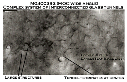
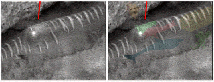
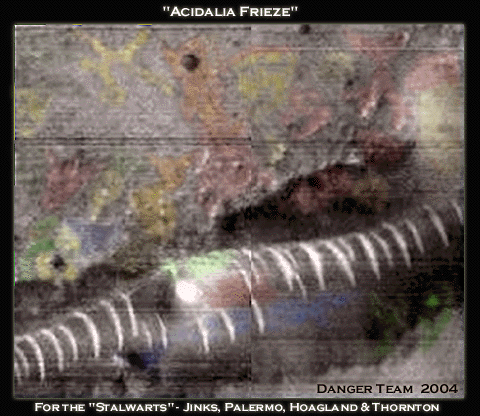
Acidalia Tunnel System
Crop of MOC M0400292
Wide angle context Image for M0400291
© 2004 Dangerzone Productions
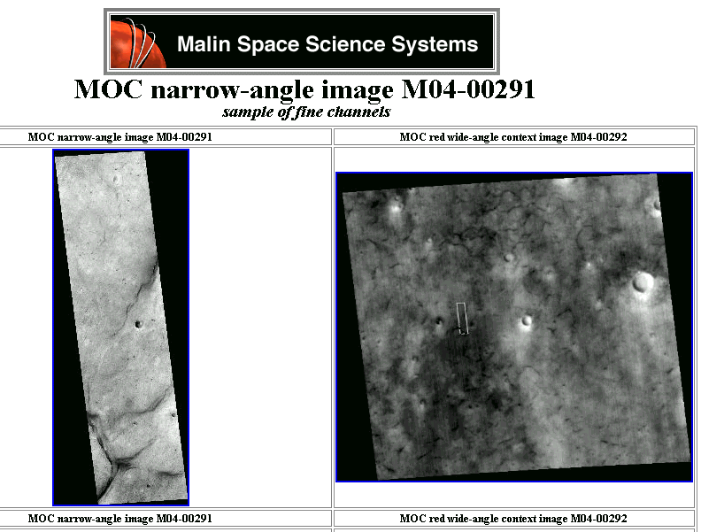
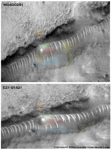
Shown below is a side by side comparison of narrow angle images for the "fine channels" of MOC M04-00291 and the "polygon trough" from MOC E21001421. The leftmost image strip is the original image taken from directly overhead the area. The strip on the right side is the newer image taken from 60 kilometers down range. The strip to the right is wider and shorter than the original, but is lower in resolution and has a a pixel aspect ratio of approximately half that of the original image, distorting it somewhat when compared to its precursor.

Image courtesy of John Levassuer
© 2004 Dangerzone productions
The slightly wider image strip worked to the disadvantage of the camera operator. The incoming tunnel in M04-00291 was truncated to the northeast corner. E21-01421 covers more area to the northwest and clearly shows our glass tunnel running above the surface before gradually becoming covered with debris and disappearing entirely. One can easily follow the tunnels underground path by following the "creekbed" along the surface until it once again resurfaces just prior to the three way junction in the abyss. My guess is this clear indication that this was no sand dune had something to do with MSSS's silence on the image. Have you ever seen a sand dune go underground and resurface a kilometer later? These things run for miles just under the surface of Mars. Why do our taxpayer funded scientific bodies refuse to acknowledge the existence of such edifices and dedicate appropriate research time towards unlocking their mysteries?

Incoming tunnel in Acidalia Planitia
© 2004 Dangerzone Productions
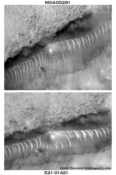
Analysis of this 1.75 kilometer tunnel section confirms the tubular nature of the structure. M04-00291 was imaged from directly overhead. E21-01421 was imaged at an emission angle of 31 degrees, giving us a look at the side of the glass tunnel as opposed to looking straight down on its canopy. The tunnels support ribs in both images are identical in placement, geometry and number. If our ribs are the common ripples of a Martian dune train would they not have migrated and undergone some metamorphosis over a three year period? These remain static and unaffected by climatic conditions.
Also, take note of the obvious increase
in curvature of the ribs in the lower image. In M04-00291 the image is looking
directly down into the defile onto the broad, relatively flat canopy or roof
of the tunnel. This accounts for its somewhat flat appearance. E21-01421 is
imaged at a 30 degree angle from 60 kilometers away. This allows us to look
at the side of the tunnel as opposed to the roof in the earlier image. This
accounts for the marked change in the apparent curvature of the ribs. A handy
tip is to compare the overhanging cliff faces behind the tunnel in both images.
In the lower image one can see underneath the overhang to a certain extent.
This confirms that what we are looking at is a semi-cylindrical construct raised
well above the surface of Mars. Most likely this was another factor in MSSS's
decision to keep silent on this image. This is no ordinary sand dune.
Comparison of tunnel sections M0400291
and E2101421
© 2004 Dangerzone productions
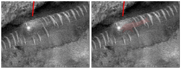
And now we come full circle. The "shiny spot" in the tube is what originally caught the eye of researchers. Conjecture on the nature of the shiny spot was never lacking in imagination except when it came to the folks at JPL/MSSS who simply wouldn't comment on it at all.
The obvious explanation for the shiny spot is perhaps the most unsettling. Occam's Razor says that the simplest explanation is most probably the correct one. That being said, the shiny spot is being created by a light source internal to the tunnel. A light source that was illuminated in the year 2000, still illuminated in 2003 and probably continues to shine on today.
This revelation carries myriad repercussions on many disciplines. A light source implies a state of high technology. A light source implies operating power sources in use on Mars today. A light source implies intelligent intervention and may be the means to confirming "as to the actual presence there of such folk" as Lowell iterated so long ago. A light source represents the fact that we are not alone in the universe. This light source represents a message of some sort as surely as a neon sign hanging outside a casino carries information to onlookers.
How can NASA deny such compelling evidence of extraterrestrial life? Rather than being caught in denial, NASA simply refuses to investigate or comment on such anomalies. Emails to MSSS from the public on such issues go unanswered. Your tax dollars at work. This area requires a thorough investigation with the full suite of instruments available to the ESA and NASA as soon as possible and the data acquired should be immediately disseminated as widely as possible for independent analysis. Let us hope that European eyes will view such anomalies with more scientific zeal than their American counterparts.
© 2004 Dangerzone productions
We will attempt to confirm the "light in the tunnel" theory by process of elimination:
The shiny spot is not:
A) An imaging artifact. It appears in both images taken three years apart, rendering the artifact excuse useless. (It is especially useless when one considers the wildly different imaging parameters used.) Also, if this represents an artifact produced by the camera, it would have shown up in a whole bunch of other images-not just these two.
B) A reflection from the sun. The two images were taken years apart, in different seasons, at different times of the day and with different angles of incidence and emission. If anything, a reflection would have moved to a different location given these circumstances-not remained in exactly the location and shown with the same intensity. And to those proponents who will still insist this is the sun's reflection we ask, since when does the sun reflect off a sand dune?
C) A reflection caused by the flash bulb on the MGS spacecraft. Good try, but the MOC camera does not use a flash bulb.
The "shiny spot" can only be coming
from a light source within the "Glass Tunnel" itself. Take a deep
breath and think about what that means. Pretty cool, huh? Finely detailed scrutiny
of the light source is, of course, mandatory for further analysis.
But first some thoughts from Lowell on the matter of "observations of fine
detail".
"Bright points in the sky or a blow on the head will equally cause one to see stars. In the first case the eyes were duly affected from without; in the second, the nerves were tapped to the same effect in mid-route; but in each case the subsequent current travels to the higher centres apparently as authentic the one as the other. Hallucinations of one sort and another occur in this way. More common, however, are unconscious changes in an originally quite veridic message. We easily see what we expect to see, but with great difficulty what we do not.
This may be due to individual idiosyncrasy, or it may be due to a prevailing idea of the time, affecting people generally, in which we unwittingly share. Fashion is as potent here as elsewhere. The very same cause will show us at one time what we remain callously blind to at another. A few years ago it was the fashion not to see the canals of Mars, and nobody except Schiaparelli did. Now the fashion has begun to set the other way, and we are beginning to have presented suspiciously accurate fac-similes of Schiaparelli's observations.
In any observation, the observer is likely to be unconsciously affected in some way or other pro or con, which, from the fact that he is unconscious of it, he is unable to find out. The only sure test, therefore, is the seeing what no one else has seen, the discovery of new detail. Next to that is not too close an agreement with others. Inevitable errors of observation, to say nothing of times and seasons, distance and tilt, are certain to produce differences, of which one has ample proof in comparing his own drawings with one another. Even too close agreement with one's self is suspicious. In the matter of fine detail, absolute agreement is therefore neither to be expected nor to be desired. All the changes so far observed on the planet's disk are, I believe, capable of explanation either by errors of observation or by seasonal change."
-Percival Lowell
In order to pursue this investigation in "fine detail" we must wholly scrutinize M04-0291 which was imaged from directly overhead. Several shapes are apparent in the original data. Having seen what an effective tool color can be in enhancing image analysis we will attempt to illustrate these shapes by colorizing them. We can honestly say this is an image that we've shown various iterations of to several hundred of individuals from all walks of life over a period of several years. Invariably, the conversations that it initiated were interesting and entertaining. Most probably the the commonest manifestation was a profession of shock from folks of varying levels of education ranging from high school grads to PhD's. Most were surprised that this was an image from Mars. An explanation of the "glass tunnel" anomalies followed and invariably the conversation turned to the "shiny spot" and the dolphin image. There were individuals knowledgeable on Mars who acknowledged the image of a dolphin but refused to view it without bias due to it's cetacean nature.
Years later, after seeing numerous effigies and intaglios in the likeness of cetaceans on the surface of Mars, some of the nay-sayers, as did Schiaparelli late in life, have come to discuss the possibility that these are artificial constructs of some sort and not pareidolia. The unusually high incidence of such apparitions has caused their belief systems have been modified enough to acknowledge the possibility.
The simple fact that the shiny spot is still present after in the same location after three years rules out two of the more radical speculations.
1) The first supposed that MGS had imaged some type of vehicle traversing the tube system. It seems unlikely that MGS would catch another vehicle in the exact same position three years later. If it's parked and sitting there apparently it has good batteries as the lights are still on.
2) The second is of course the notion that this image somehow represented a gigantic alien cetacean swimming merrily along Lowell's canals with his companions. The likelihood of catching a giant alien mega-dolphin in the same spot three years later are about as likely as a vehicle in the same spot. Practically nil. There is however, little debate that the image of the dolphin is clearly present in the original dataset. What it represents is of course, another issue.
We now feel confident enough given the incidence of similar cetacean and aquatic effigies found on Mars that state our belief that this represents as yet unquantified variation in Martian landscape art. Saints and angels of mercy preserve us, but I can't think of anything more appropriate as an explanation aside from this being an advertisement of some sort. A cultural artifact of type not seen before. Like the geoglyphs at Nazca, this Martian artwork is viewed from above as our analysis of MOC E21-01421 will illustrate. This is an invitation of the same nature as a roadside billboard hawking "a swim with the dolphins" in the Florida Keys or a flashy high tech marquee beckoning visitors to Sea World or Universal attractions. It says, "Look! We're here! Come visit us!".
Suppose the indigenous Martian civilization was eventually forced to resettle underground due to changing environmental conditions. Slowly watching there vacant surface arcologies, tunnels and other structures disappear beneath the Martian dunes , they placed this message in one of the last visible locations on the tunnel system as a beacon for others in hopes they might be rescued or relieved.
Or possibly, given the incidence of effigies and intaglios of various animals forms that are seen on the surface, this is simply denotes another attraction at the Martian interplanetary zoo. Either way, it signifies something specific. Of course we'll have to visit Mars to verify such an epiphany.
Some possibilities on the nature of the anthropomorphic shapes inside the glass tunnels spring to mind. All imply intelligent intervention, just as Lowell suspected.
A) These are large static models mounted inside of the structure, somewhat analogous to the resurrected dinosaur facsimiles one sees in a natural history museum. A well lit display of some sort.
B) These are designed images that have been applied to the tunnel floor or glass, lit from within and refracted through that medium so as to be visible from above.
C) The images are somehow embedded into the matrix of the translucent canopy in a manner analogous to stained glass.
D) Along similar lines to C this could also be some type of visible light hologram technology bonded onto the canopy material itself. This might help those of you who have a problem with the power source for the lighting as this would require only ambient sunlight for illumination.
Future data collected on this area may shed some additional light on this issue but more likely it will take a trip to Mars for definitive answers.
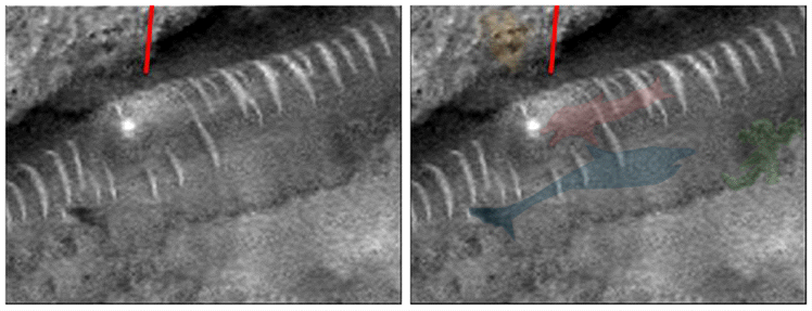
And now we invite you to participate in the final installment of Johnny Danger's Dangerous Martian Rorschach Test as we examine the fine details of around the "light in the tunnel".
Working from the Enterprise Mission's original
enhancement of the area, as previously shown, our first image is the "Giant
Alien Mega-Dolphin" of Internet fame. Mega-Flipper checks in at around
170 meters in length.
The Giant Alien Mega-Dolphin and Friends
Images courtesy of Eric C. Lausch and
Kevin Klettke
© 2001 Dangerzone productions

Next we ask you direct your attention to
right side center, where we find a most unusual little fellow. We call him the
megapotamus. Take note of the stream of bubbles rising above
him. He measures around 75 meters and appears to have very pronounced brow ridges
and a long bulbous tail.
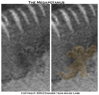
The Megapotamus
© 2002 Dangerzone productions
Some of you may remember us referencing the megapotami next to the tunnel from MOC image strip M15-01228. Earlier we discussed the possibility that our megapotami were a variety of smaller scale effigies that have for the most part escaped detection due to their relative size and our imaging capabilities. Here we have a comparison of the megapotami effigies from M15-01228 and the megapotamus from M04 -00291. This is another image we have personally shown to a large number of individuals. Far and away the great majority of these folks have said they believe these to be representations of similar entities. Both are found in the area of a large tunnel segment which implies a relationship between the megapotami and the glass tunnels. As stated earlier, one object makes an anomaly. Finding similar anomalies begins to reveal a "class" of objects.
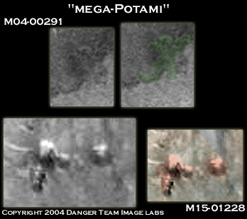
Megapotami
© 2004 Dangerzone productions
In the next frame we illustrate two new
areas in the crop. The first being a potential carved "face" on the
rock wall of the cliff overhang. Many individuals have reported seeing an arrow
to the right of the face. Perhaps it's just a coincidence that the Cydonia face
lay just 79 kilometers away in that direction. Swimming directly alongside Mega-Flipper
we have our Megalodon shark, Uberjaws. He measures in at 300 meters. It would
seem the megapotamus is madly swimming to get out of Uberjaws way!
Directly behind the Mega-Dolphin's tail,
we see two large eyes peering out at us. What we can only describe as a "Mega-Walrus"
complete with tusks. Mega-Wally seems to fill the glass tunnel with his girth.
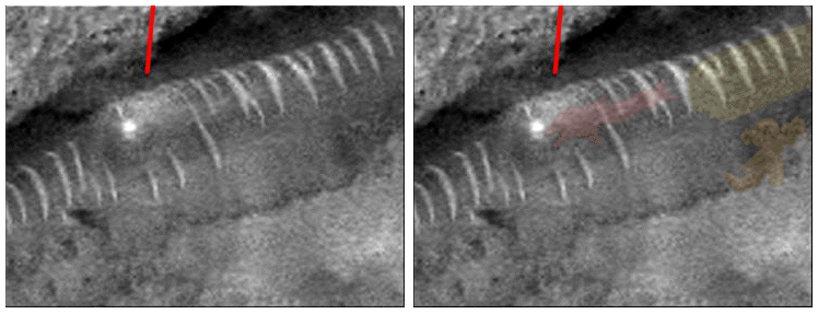
Immediately to the rear of the dolphin's
head we see a curious sight. An upraised hand with three long digits seems poised
above the glowing sphere which generates the light source. To the rear we see
three "Martians", their heads just peeking above Mega-Flipper.
In the final frame we see what appears to
a conveyance of sorts that the Martians are riding in. Adorning the the bow
of the vehicle is what appears to be the face of a large cat. The mega-dolphin
appears to have one of the catmobiles protruding ears in its mouth, as if to
pull the conveyance along the tunnel.

The Giant Alien Mega-Dolphin and Friends
Images courtesy of Eric C. Lausch and
Kevin Klettke
© 2001 Dangerzone productions
Well, how about them apples? Probably not what you'd have initially envisioned for such an intellectual undertaking as the exploration of Mars. The bottom line is that these artifacts do appear in the original data for MOC image M04-00291. If these images truly represent physical objects within the glass tunnel or are the manifestation of some holographic technique there should be some indication of them in MOC image E21-01421, albeit at a lower resolution and somewhat different perspective due the imaging parameters, sun angle and relative position of the spacecraft to the target.
As the refractive index of the tunnel material and the radius of curving tunnel canopy is unknown, it is hard to estimate what effect the large emission angle will have on the anthropomorphic shapes if we are actually viewing them through the refractive medium or "lens" of the glass tunnel canopy. Distortion along the lines of a funhouse mirror are possible, making one appear impossibly tall or incredibly squat. Still, the imperfect glass of the funhouse mirror can only distort the actual subject, not create the apparition out of thin air. It follows then, that while the forms may be distorted, if we can reasonably identify them in the new image then they are indicative of actual physical artifacts being imaged in the visible spectrum.
"Even too close agreement with one's self is suspicious. In the matter of fine detail, absolute agreement is therefore neither to be expected nor to be desired."
-Percival Lowell
The Giant Alien Mega-Dolphin and Friends-Revisited
Image courtesy of Eric C. Lausch
© 2004 Dangerzone productions
Whether cultural artifacts from a lost civilization or dolphins in the sand, as always, in the end, we ask that you be the judge.
Whatever you decide, one issue is non-negotiable. There is a light in the end of the tunnel. Such a light source can only be explained as the byproduct of intelligent intervention on the planet Mars.
Believe your eyes.
Not convinced? We ask your indulgence and beg one last time that you follow our presentation to it's climax.
The Doctored Image and the Pareidolia Paradigm
If your eyes are not yet accustomed to the Martian lighting we'd recommend squeezing them tightly before looking at this image. No Johnny Danger piece would be complete without an all encompassing shadow of conspiracy hanging over it and we've given our taxpayer funded planetary science organizations wide latitude thus far, chalking up their reticence to see beyond the "sand dune" as either human error or standing operating procedure on the battleground of governmental budgetry.
After all, anyone could forget to convert the units from metric to standard and miss an entire planet, right? Allowing for budgetary restraints, labor issues, e-mails from the public to read and delete along with a myriad of other issues to attend to some mistakes are bound to happen.
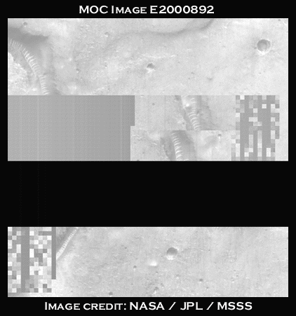
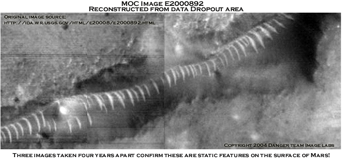
Unfortunately, there seems to be no mistake with regards to MOC image E2000892. Tricks of light and shadow aside, MOC image E2000892 has another of those annoying data dropouts that continually plague the most tantalizing of Mars images. Having looked at thousands of Mars images over the past years we have seen plenty of these. Coincidentally, the data loss areas seem to have an almost paranormal quality of positioning themselves directly over the most sought after features. Not being unwary of coincidence, at first we simply thought, "Oh, there's another one".
However, this one looked different somehow. It was only after consulting the latitude and longitude that it became clear that this was a third image of the original "Glass Tunnels" discovered by Richard C. Hoagland back in 2000. After checking the date it became apparent that this was not a third image of this area in Acidalia - it was the second image, having been taken September 17, 2002, over a month prior to MOC image E210421 which was acquired on October 27, 2002. Both images were released around a year later on September 30th, 2003 and posted to the Internet with a flood of other MGS images.
And therein lies the makings of conspiracy
theory worthy of the mythos of the Martian canals and their esteemed curator,
Percival Lowell.
MOC Image E20000892
Data dropout courtesy of NASA / JPL / MSSS
MOC image M0400291 (the original image discovered by Hoagland) was taken in 1998 but not released untill 2000. This sequestering of new Mars data for prolonged periods of time was what initially sparked the FACETS litigation. As MSSS / JPL was indeed in violation of their contractual agreement with regards to the timely release of data acquired they agreed to target five sites on Mars at FACETS behest.
Under such circumstances it would seem reasonable to assume that reimaging this area would become a priority target for MGS. It would follow then that the new data would be released to the public expeditiously and certainly by the end of the JPL / MSSS proprietary data period.
MOC E2000892 proves that the Acidalia tunnels were reimaged the following year after the agreement was reached between NASA and FACETS. A year, give or take a few months is not an unreasonable length of time to fulfill such a promise given the nature of planetary science and the constraints of time, equipment and orbital path logistics. At this point it looks like NASA possibly intends to keeps it's promise in good faith although their withholding and spin doctoring of the FACETS Cydonia reimaging data has already revealed their intentions to be less than forthcoming on these matters.
Now with this image in NASA's possession you would think they would be concerned about the public relations aspect surrounding it and release the image immediately. They do not. Instead they wait another six weeks and acquire a third image of Acidalia Planitia, MOC image E2101421 on October 27, 2002 when the spacecraft is 60 kilometers downrange. The MGS mapping orbit moves the spacecraft further away each day. It takes about 13 hours to transmit an MOC narrow angle image. Why wait six weeks as the spacecraft moves further away from the target to take another image? Then after acquiring the third image, rather than release the data to the public that requested it, they sit on both images for another year. This makes absolutely no sense whatsoever given that they were originally forced to re-image the area as a direct result of their not releasing data acquisitions in timely manner.
Why would NASA do this? They've released lots of images with these data dropouts since 2000. It posed no apparent problems NASA / JPL / MSSS on to release such images on other occasions. They didn't return to those sites six weeks later to retarget the area. Why was this area treated differently? Now while there are those of you out there who will contend that NASA did this in the public interest to deliver a complete image of the area for analysis, I think this assumption will not stand on its merit.
Obviously the folks at MSSS knew why they were forced to retarget this area. Obviously MSSS scrutinized the image and determined that they need an additional image for some reason. If the reason was to provide good customer service to the taxpaying American which funds them then why would they once again violate the contractual stipulation to release the data on time when this was the original impetus for the FACETS litigation? It makes no sense at all.
A close examination of the image and ancillary data suggests that
the acquisition of the third image was done not for the benefit of the American
citizen but to perpetuate a hidden NASA agenda of obfuscation and disinformation.
| M0400291 |
4A
|
Gain mode Exposure of the MOC is limited by the line-time. The MOC is only able to covert this light into, at most, 256 shades of gray (black to white). "Gain" is used to take the actual spread of brightnesses and scale it to 256 levels (8 bits). See the PDS products for details on the meaning of gain values stated here. |
| E2000892 |
2A
|
Gain: As we know from previous analysis the 2A setting increases gain by 30% over the 4A setting. This will increase image contrast yielding a crisper image than 4A if both have the images use the same offset mode value.
| M0400291 |
26
|
Offset mode "Offset" is used in concert with "gain." It shifts the maximum number of grays (256) into the range of the analog-to-digital converter. See PDS products for details on the meaning of offset values stated here. |
| E2000892 |
26
|
Offset mode: By keeping the offset mode setting constant and increasing the gain we should get a sharper image. This is what you'd expect to see in a deliberate attempt to acquire a superior image.
| M0400291 |
27.08W 39.12N |
Longitude and Latitude come from the center of the graphic |
| E2000892 |
27.10W 39.08N |
Longitude & Latitude: Very close to the original coordinates. Another positive in acquiring a good image.
| M0400291 |
410.24km
|
Spacecraft altitude This number tells how high the MOC and MGS spacecraft were above the surface of Mars when the center of the image was acquired. |
| E2000892 |
412.4km
|
Altitude: Approximately the same. MGS orbit was slightly higher for the second image.
| M0400291 |
410.24km
|
Slant distance This number is similar to the spacecraft altitude, but also takes into account the emission angle...if the emission angle is 0 then this number is the same as the spacecraft altitude. If the emission angle is much greater than 0, then the "slant distance" to the surface at the center of the image is also greater than the spacecraft altitude. |
| E2000892 |
428.68km
|
Slant distance: MGS is approximately 17 kilometers downrange. This is far superior than the 60 kilometer difference we in MOC image E2101421.
| M0400291 |
.15
|
Emission angle Measured from the center of the image, this is the angle between the MOC and a "normal" drawn perpendicular to the planet's surface. In most cases, the MOC is looking "straight down" and the emission angle is thus close to 0¡ |
| E2000892 |
16.8
|
Emission angle: The emission angle for MOC E2000892 (second image) is approximatley half that of MOC E2101421 (third image). This would yield a better result than than the larger emission angle. Another positive.
| M0400291 |
3.07m
|
Scaled pixel width This is the image resolution in meters per pixel at the center of the image. For most narrow angle images, this value will be approximately the same over the entire picture. For wide angle images, the pixel scale will vary over the image. |
| E2000892 |
3.35m
|
Scaled Pixel width: Approximately the same resolution for both images. This bodes well for comparative analysis. Higher resolution would be preferable but equal resolution is certainly preferable to lower resolution.
| M0400291 |
1.42m
|
Pixel aspect ratio This is the ratio of pixel scale down the image to across the image. An image with an aspect ratio that is not 1.00 is an image in which the pixel scale is different between the pixels across and the pixels down. For example, an image in which the pixels across have a resolution of 1.5 meters per pixel and pixels down have a resolution of 2.25 meters per pixel has an aspect ratio of 1.5:1, or "1.5" |
| E2000892 |
.91
|
Pixel Aspect Ratio: The closer the pixel aspect ratio is to the value "1" the less distortion across the image axes. Another positive. This picture would be be superior to the original image.
| M0400291 |
186.17
|
Solar longitude (Ls) This is the position of Mars relative to the Sun measured in degrees from the vernal equinox (start of northern Spring). This number is used as a measure of Martian seasons: Northern Spring/Southern Autumn start at 0¡, Northern Summer/Southern Winter start at 90¡, Northern Autumn/Southern Spring start at 180¡, and Northern Winter/Southern Summer begin at 270¡. |
| E2000892 |
69.28
|
Solar Longitude: Close to the data for E2101421 as they were taken only a month apart.
| M0400291 |
54.45
|
Incidence angle Derived for the center of the image, this is the angle between the Sun and a "normal" drawn perpendicular to the planet's surface at the time the image was acquired. A higher incidence angle means that a person standing on the ground would see the sun lower toward the horizon. |
| E2000892 |
32.3
|
Incidence angle: The sun is higher in the sky lessening the effect of shadow in a black and white image. Combined with the smaller slant distance this is another positive over E2101421.
| M0400291 |
54.45
|
Phase angle This is the angle between the sun, the surface, and the MOC at the time the picture was obtained. |
| E2000892 |
16.82
|
Phase Angle: The lower phase angle should combined with the lower lower incidence angle should serve to reduce "Tricks of light and shadow". Another postive.
All things considered MOC E2000892 should have been a great image, far superior to either MOC 0400291 or MOC E2101421. Careful examination of MOC image E2000892 leads this author to the conclusion that this is exactly what happened. MGS acquired an image that blew the folks at MSSS away.
It also scared them witless. MOC E2000892 clearly revealed the presence of intelligent intervention on Mars and the artificial nature of the "Glass Tunnel" anomalies. What they saw in this image scared them so badly that someone ordered the altering of MOC image E2000892 - distorting, deleting and reordering swaths of image data to hide the true nature of this area.
The result was the image as seen below. A streaked, under-intensified image
with large chunks of data that have been deleted and rearranged from the original
data acquisition. After looking at dozens of these data dropouts we realized
that this was the only MOC image we had seen that had areas of the image reordered
from the original data acquisition. This was very suspicious and we decided
to further investigate this issue.
Data loss area from MOC Image E2000892
Quoting from The Mars Orbital Camera Software Interface Specification -MOC Narrow Angle and Wide Angle Decompressed Standard Data Products by M. Caplinger, Malin Space Science Systems, Inc.( http://ida.wr.usgs.gov/corrections/mocsis.txt):
All MOC images must be a multiple of 16 pixels in both width and height. Images are broken up into subimages (also called fragments), and each fragment is transmitted separately. Raw and predictively compressed images are reconstructed by concatenating all of their image fragments and then processing; transform compressed images are pro- cessed a fragment at a time. A MOC data product consists of one image with decompression applied. In the event of data loss caused by packets dropped in the space-to-earth link or in the ground segment of the DSN, a standard first-order correction algorithm has been applied. Selected MOC images may have had additional corrections applied; this archive represents the best available reconstruction at the time of archive production.
As a caveat to this MSSS also informs us:
MOC images can be compressed before being transmitted to Earth. For example, "NONE" means that the image was not compressed, "PRED" means that the image was predictively compressed, "DCT" means discrete cosine transform compression was used, and "WHT" is Walsh-Hadamard transform compression. Numbers following compression type indicate lossless, lossy, and compression factors used. (http://www.msss.com/moc_gallery/ab1_m04/explain.html)
This is pretty much all the information available with regards to this issue that is readily accessible to the lay person and it's extremely unenlightening.
Thus we will resort to common sense and our long history of viewing Mars images. We will note that both M0400291 and and E2000892 both utilize normal predicted (PRED) data compression while E2101421 was transmitted using discrete cosine transform (DCT) compression. After sampling a large number of MOC narrow angle images we can state that the only image we can find that uses DCT compression is E2101421. This leads us to believe that this was yet another subtle way to further degrade the image along with the adverse manipulation of MOC imaging parameters.
In fact, there is very little about the imaging parameters utilized
in acquiring E2101421 that can be correlated with the majority of MOC narrow
angle images. This smacks of a cover-up. A deliberate attempt to acquire a substandard
image. Your tax dollars at work. And to what end? To protect the delicate sensibilities
of a society whose love of space and aliens has kept Star Trek on television
for almost 40 years? I hardly think they need protecting.
MOC camera block diagram
The MOC camera acquires the image line by line as it physically moves over the surface of Mars. It is reasonable to assume that the data is transmitted in a similar manner, that is to say, in a linear fashion. I sincerely doubt that the compression algorithm reduces the image to into fragments and then randomly scrambles the fragments to be reassembled upon receipt. Simple common sense indicates that this would be a very inefficient manner with which to utilize such a valuable resource as MGS imaging time. If this is the case then what is the root cause of the data rearrangement?
As in the case of Martian anomalies, intelligent intervention
seems the likely culprit. Or perhaps the MGS was passing through a weak spot
in the space time continuum and some of the data moved backwards in time only
to reappear a few seconds later and be transmitted once again back to NASA belatedly
and out of formation, like a child engaged in a round of interstellar leapfrog.
If only Mr. Lowell could weigh in on this issue.
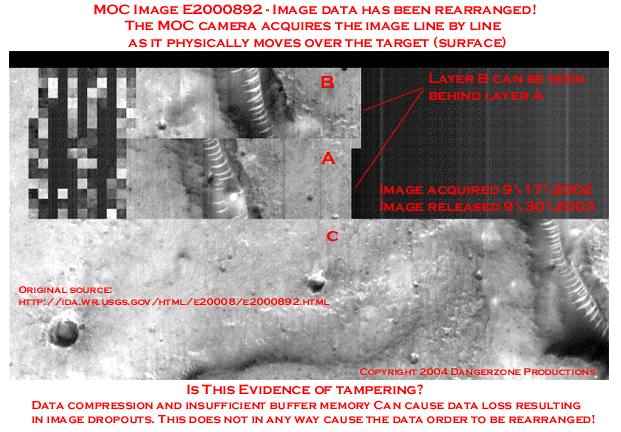
Image courtesy of NASA / JPL / MSSS
Here is a description of MOC data transmission capabilities from
the NSSDC master catalog of experiments:
"Because of the high volume of data which imaging experiments
can generate, the MOC electronics contain not only a large amount of memory
(~12 MB DRAM buffer) for processing and storing the images, but also have the
capability of utilizing a number of data compression techniques (both lossless
and lossy). Further, the MOC can transfer these data (either to the on-board
recording system or via real-time transmission) at any rate of which the spacecraft
is capable. As a result, the equivalent of two, four, or eight (depending on
mission phase) 2048 x 2048 pixel images can be processed on record-only days
and, once every three days on average, fourteen such images can be processed
and sent during an eight-hour real-time pass."
(source: http://nssdc.gsfc.nasa.gov/database/MasterCatalog?sc=1996-062A&ex=1)
Data dropouts are reportedly caused by insufficient buffer memory in the MGS. Images are acquired faster than they can be transmitted back to NASA, While waiting to be transmitted the image resides in the MGS buffer memory. The time spent in the buffer is referred to as "residence time". MOC images are assigned a priority in case buffer capacity is exceeded. Narrow angle images are assigned a higher priority than wide angle images.
Thusly, a wide angle image waiting in the buffer would be subject to data dropouts when superseded by a narrow angle image with higher priority. However, we would be remiss if we failed to mention that all MOC image priorities can be interactively assigned by the user at MSSS. Of course, no one at MSSS would assign this image acquired at the behest of the American public with a low image acquisition priority. If they did I'd bet they caught Hell from the boss since they were then forced to acquire another image of the area six weeks later at the cost of $40,000.00 per image. (Of course, amortized over the life cycle of MGS this number goes down-so perhaps the bean counters forgave the culprit!) Once again, your tax dollars at work!
Again, not being unwary of coincidence, we pose an additional conundrum to interested parties:
Given that MGS data is transmitted in a linear progression from beginning to end, wouldn't an image waiting in the buffer for transmission which had been superseded by a higher priority image have all the data losses at the leading edge of the image? Yet we continually see these blacked out areas strategically placed over the most anomalous features in the image strip at various location in the data transfer. We have high hopes that someone out there can adequately explain this situation as computing efficiency and common sense both fail to explain such curious circumstances.
Lowell's bookie has assured us that he would give odds that some overzealous anomaly hunter out there would start comparing the fragmented portions of the data dropouts and discover a repeating pattern in the checkerboard of data. It's almost as if someone had created an image swath of 16 pixel wide squares to paste into into MOC images over areas of high strangeness.
But enough of such talk. Let us examine the repaired image strip
and see what was so shocking as to require such extraordinary measures of duplicitousness.
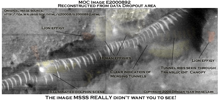
E2000892 reconstructed
Image courtesy of J. Danger
Special thanks to David Jinks
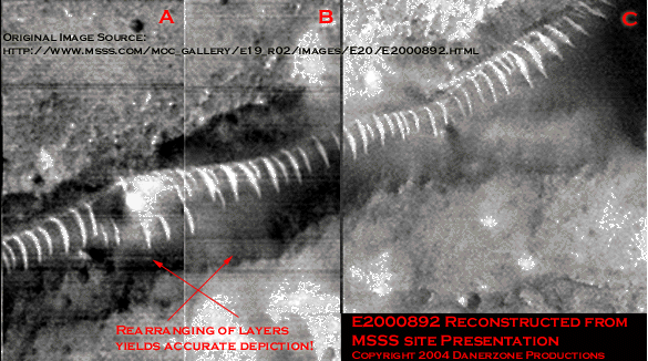
Proper rearrangement of the image layers from the image posted
on the MSSS site does indeed show this to be the immense tunnel junction in
Acidalia Planitia. Once again our shiny spot dominates the image, sticking out
like the proverbial sore thumb. Corroborating the Acidalia image swath is about
all this image is useful for. However, as is the norm, the USGS Mars site sports
an image of much higher quality than the MSSS site. While still showing streaks
from improper use of the NASAVIEW comb filter (and stiill with rearranged data
swaths) the good folks at USGS have indeed posted an image of higher quality
than the erstwhile imaging gurus at MSSS. Once again the anomalous entities
seen in M0400291 and suggested in E2101421 are clearly visible despite the streaking
and overall poor image quality. Other items of interest are also readily apparent.
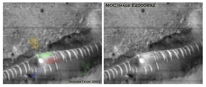
Special thanks to NASA / JPL / /MSSS
Firstly, it seems inconceivable that MSSS would go to such lengths to hide an anomaly like the Mega-Dolphin as it can readily excused as pareidolia despite its appearance in three separate MOC images. Secondly, there is no way to obfuscate the existence of the "Glass Tunnels" as they appear in so many different MOC images. This would be pointless.
What then did the good planetary scientists at MSSS see that compelled them to take such extraordinary measures to degrade these images? Giant Alien Mega-Dolphins aside, this author, for one, believes they were confronted face to face with their worst nightmare.
FACES ON Mars.
One can almost imagine the collective groan at MSSS, "Oh great! Another big face!"
Seeing is believing. Believe your eyes.
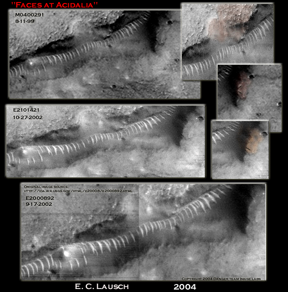
Image courtesy of Eric C. Lausch
© 2004 Eric C. Lausch & Dangerzone Productions
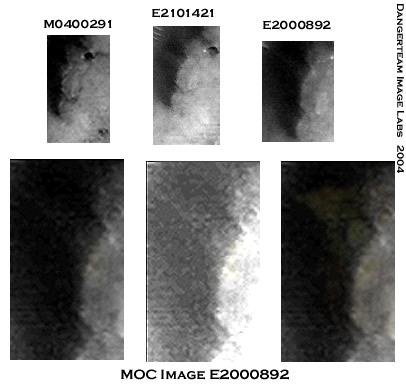
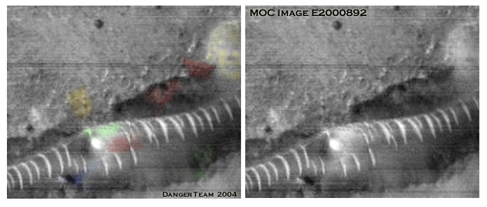
Recently we had the opportunity to show these three image strips to two graphics professionals with over 30+ years of imaging experience between them. They come from diverse backgrounds. Neither knows much about Mars and even less about Martian anomalies and conspiracy theories. As they were both shown the image strips separately we were somewhat taken aback by their exactly similar responses. They both said, "Blur tool".
The original image, M0400291 is demonstrably sharper and better
contrasted than the subsequent images. Perhaps a "blur tool" is the
only logical explanation. This would explain why the left side of the face is
blurred in E2101421.
Acidalia Split Faced Glyph
While this is hardly proof of tampering, these individuals have
credentials which make them expert witnesses on such matters. There are certainly
enough unusual circumstances surrounding this image to cast a reasonable doubt
in the jury of public opinion. It makes one wonder about all the image dropouts
and otherwise unviewable areas in numerous MOC images. Unfortunately, this could
also mean someone may have been altering evidence of Martian artifacts in images
since long before the initial MSSS mission data release of MGS images in 2000.
Your tax dollars at work. This really would make a great X-Files episode.
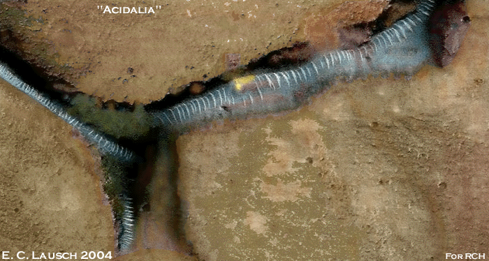
The Faces at Acidalia Planitia
Image courtesy of Eric C. Lausch
Shown above is the Danger Team's rendering of what we think a decent 2m\pixel ESA HRSC color image of the Acidalia Planitia tunnel junction might yield. All colors utilized in this image were directly sampled from ESA HRSC images. Mars is not the dead planet of Carl Sagan's era. It is a place of blues and green and reds. The more we learn about Mars the more we realize how little we really know about our sister planet. Lowell's bookie would most likely give 300 to one odds that these are indeed artificial constructs on Mars.
The implications of another large effigy in the form of a split faced glyph on Mars are not lost on us. Once again we see examples of a class of recurring objects on the surface of Mars, large scale effigies or landscape art appearing in conjunction with the "glass tunnel" anomalies. How much longer can mainstream science continue to dismiss this recurring set of linked objects as sand dunes and pareidolia?
Like Lowell and Schiaparelli before us, we choose to believe our
eyes.
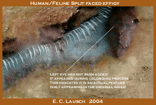
The Faces at Acidalia Planitia
Image courtesy of Eric C. Lausch
It goes beyond interesting to note that the left eye of the split faced effigy which is clearly visible in the colorized image is not a contribution of the artist. This feature simply "popped out" during the colorizing process. This is indicative of tonal variations in the shading on the left side of the effigy. Unlike the highly eroded "Face" at Cydonia this effigy, like that of "Oannes" at Grand Central, appears intact and recognizable. Indeed, with all the potential eroded archaeological artifacts seen in Mars images it seems that only the ones directly adjacent to the glass tunnel anomalies are found in a state of relatively good repair.
It's enough to make one wonder who's in charge of their upkeep.
And now we've come full circle. Four years later the tube is clearly not a sand dune. Sand dunes change eventually as Aeolian forces rearrange their components faster than crops from an MOC image prior to release. These edifices are static and unchanging. And yes, the Mega-Dolphin still swims merrily along Lowell's "Canals". We believe this would have made Lowell happy.
It's beginning to look like Percival Lowell will be the last man standing when the 200 year debate on the nature of Mars finally is settled.
Good for him. And thanks for all the great Sci-fi!
And now for those hardy souls who have ventured so far down the path less taken
we give you the the final exercise in Johnny
Danger's Dangerous Martian Rorschach Test.
Reconstruct MOC image E2000892 for yourself and enhance it to
the best of your ability. Print it out on a decent printer and give it to
gifted
child along with a box of crayons. Without looking at the child's results -
repeat the excercise yourself.
Then compare it to this. We'd wager that you're going to see a lot more inexplicable
images than this one in Acidalia Planitia as our Mars surveillance capabilities
increase over the next decade or so.
Is this pareidolia? Perhaps. Or Perhaps not.
"Food for thought"
Image courtesy of Johnny Danger
Thus we bring this episode of "Tunnel Surfing with Percival Lowell" to a close.
As for the premise of this dissertation, it is our loss that such brilliant and intuitive scholars as Schiaparelli and Lowell are unable to participate in the adventure of our contemporary Martian explorations. Their insights on modern data acquisitions might prove enlightening. After all, they did have an advantage over this generation of Martian explorers. They saw Mars live with their own eyes. We only get to see Mars in small, tightly controlled snapshots that are either censored, overlooked or deliberately leaked by insiders wishing to disseminate the information. As NASA may deign to rebut such contentions we sincerely hope that our associates in the Planetary Science community will engage in some spirited comment on these issues, both pro and con.
Both positions, when pursued sincerely, help to foster a better understanding of the universe we live in.
Our long hiatus from the Mars anomaly battleground
has served to give us a new perspective on the mysteries of Mars. It may well
be that another considerable period of time will pass before the shades of Schiaparelli
and Lowell accost us in the night, urging the Danger Team to take to the field
once again. As such persistent specters as these will eventually cause even
the hardiest of souls to capitulate, we suspect it will be a sabbatical of substantially
shorter duration than our last.
Until then - pareidolia aside - we bid you good anomaly hunting.
Just prior to his death in 1916, Percival
Lowell summarized his thoughts on Mars:
"Since the theory of intelligent life on the planet was first enunciated 21 years ago, every new fact discovered has been found to be accordant with it. Not a single thing has been detected which it does not explain. This is really a remarkable record for a theory. It has, of course, met the fate of any new idea, which has both the fortune and the misfortune to be ahead of the times and has risen above it. New facts have but buttressed the old, while every year adds to the number of those who have seen the evidence for themselves."
-Percival Lowell
Lowell's summary remains as applicable today as it was in 1916. Seeing is believing.
Believe you eyes.
-Johnny Danger