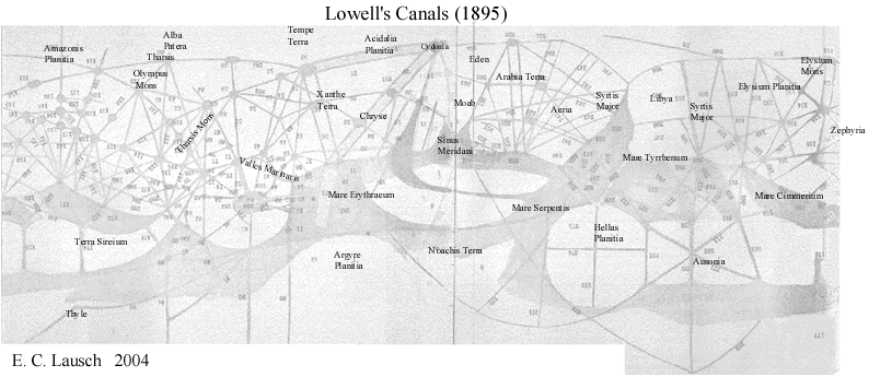
Lowell's Legacy- Part 6- Lowell's canals - Acidalia Planitia
"in the last chapter
we saw how badly off for water Mars, to all appearance, is; so badly off that
inhabitants of that other world would have to irrigate to live. As to the actual
presence there of such folk, the broad physical characteristics of the planet
express no opinion beyond the silence of consent, but they have something very
vital to say about the conditions under which alone their life
could be led.
They show that these conditions must be such that in the Martian mind there
would be one question perpetually paramount to all the local labor, women's
suffrage, and Eastern questions put together--the water question. How to procure
water enough to support life would be the great communal problem of the day."
-Percival Lowell
Scrutinizing Mars through his telescope during
the 1894 opposition, Lowell meticulously sketched a series of plates detailing
the complex hub and spoke system of interconnected "canali" which
he believed was intelligently designed and built for the purpose of circulating
water to all corners of Mars. Not having access to our contemporary imaging
and spectrometer data Lowell had no way of knowing that Mars has vast regional
aquifers containing enough water to cover the entire planet to a depth of several
meters as well as surface ice and liquid water existing at some locations
of low elevation.
Enough water to justify construction of a planetary water system to procure
this vital resource for the needs of it's builders. There are indications that
Mars is still hydrothermally active, if so, given Lowell's penchant for speculation,
Percival probably would have hypothesized a thriving ecosystem filled with alien
beings under the surface of the red planet traveling about on their daily business
hurtling down the glass tunnels of Mars, weary travelers on an alien interstate.
This phenomenon that astronomers observed on Mars can hardly be attributed to
pareidolia as it does not resemble any type of physiognomy, but is more readily
likened to a map of the hub and spoke system commonly used to route commercial
air carriers or possibly to some type of large transportation system.
"The map represents that part of the planet lying between latitudes 70 degrees south and about 40 degrees north. The south circumpolar regions will be found in the chart of the south pole facing page 84. The northern ones were not presented to view at the last opposition, owing to the tilt toward us of the Martian south pole. No canals, therefore, north of about 40 degrees north latitude were visible."
-Percival Lowell
Lowell-Plates 24A & 25B
Details of the Martian canal system
"The result is that the whole of the great reddish-ochre portions of the planet is cut up into a series of spherical triangles of all possible sizes and shapes. What their number may be lies quite beyond the possibility of count at present; for the better our own air, the more of them are visible. About four times as many as are down on Schiaparelli's chart of the same regions have been seen at Flagstaff. But, before proceeding further with a description of these Martian phenomena, the history of their discovery deserves to be sketched here, since it is as strange as the canals themselves."
-Percival Lowell
Image M1901684
Image courtesy Keith Laney
Indications of the glass tunnel
anomalies appears in numerous MGS images as parallel striations, the ribs, so
to speak of these inexplicable "sand dunes"just protruding above the
surface of Mars. Image M1901684 (above) bears a striking resemblance to what
Lowell drew in plate 24A and 24 B where the canal (tunnel) acts as an apparent
boundary line for dramatic changes in surface color and topography, possibly
a byproduct of the process Schiaparelli called "gemination", thought
by Lowell to be strips of verdure or possibly agriculture found directly adjacent
to the "canali". Both agreed the colorful changes in topography were
due to vegetation of some sort. Could this be a Martian prairie lain fallow
by meteorological conditions currently on Mars? Might it bloom again in the
coming century?
This image also contains one of those annoying data dropouts that seem to occur
in only the most interesting of image strips. It probably showed a Martian
sprinkler
shack or some other culture shaking revelation. Alas, no one but Dr. Malin
knows for sure.
As one considers MOC Image m0400291a
I would recommend our readers to utilize the url listed and study the full size
image at the USGS site. I can almost hear Lowell scoffing at the ridiculous
notion that these are simple dune trains. These fantastic anomalies run for
kilometers, with diameters a two football fields wide prior to plunging once
again beneath the surface of Mars. How uncanny the resemblance of this image
becomes when compared to the nexus and nodes of Lowell's canals.
This author, for one, believes these anomalous "glass tunnel" images
found in numerous images from the Acidalia Planitia region are indeed related
to what Lowell and others observed on Mars during the nineteenth century on
Mars. Remnants of a larger infrastructure or planetary system still visible
to our scrutiny. It certainly looks to be more recognizable as one of Lowell's
canals than it does as the sand dune which the Jet Propulsion Laboratory's standard
explanation reputes it to be. Our taxpayer funded researchers have chosen to
simply write them off in the same fashion which they have used relegate the
majority of unusual artifacts on Mars-by proclaiming them to be sand dunes.
Whether of natural origin or artificial design, these immense structures bear
further scrutiny.
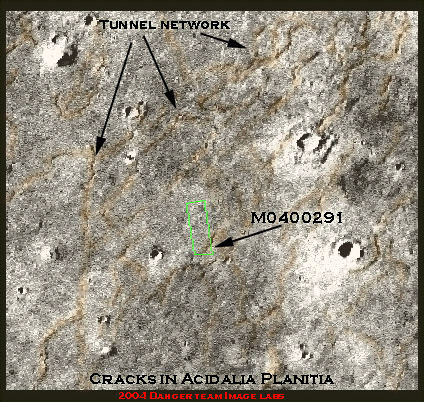
Viking Context image for M0400291
©2004 Dangerzone Productions
MOC Image m0400291a
http://ida.wr.usgs.gov/fullres/divided/m04002/m0400291a.jpg
Special Thanks to the Enterprise Mission
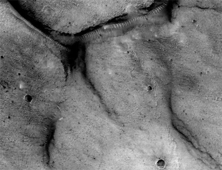
"But, singular as each line looks to be by itself, it is the systematic network of the whole that is most amazing. Each line not only goes with wonderful directness from one point to another, but at this latter spot it contrives to meet, exactly, another line which has come with like directness from quite a different direction. Nor do two only manage thus to rendezvous. Three, four, five, and even seven will similarly fall in on the same spot,--a gregariousness which, to a greater or less extent, finds effective possibility all over the surface of the planet. The disk is simply a network of such intersections."
-Percival Lowell
MOC image E020647
Image courtesy of Eric C. Lausch
With that last MOC image E020647 clearly shows multiple tunnels converging in a manner unmistakably evocative of Lowell's description and to those in MOC image m00400291a. A branch tunnel can be seen running for kilometers from the interchange as it submerges beneath the surface only to reappear a short distance later as it breaks out above the regolith in several more locations. Ever see a sand dune go underground?
"In the case of the double canals, the spots look like rectangles with the corners rounded off. One of the most striking of all of them is the Trivium Charontis, which is nearly square. Now it will be noticed that these shapes are as unnatural as they are definite, and that they all agree in one peculiarity: they are all convex, not concave, to the entering canals. They are not, therefore, mere enlargements of the canals, due to natural causes; for, were the spots enlargements of the canals, at their crossing-points they should be more or less star-shaped, or concave to the canals, whereas they are round, or roundish rectangles,--that is, convex to the same. Such convexity negatives, at the outset, their being purely natural outgrowths of the canals."
-Percival Lowell
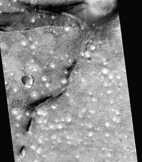
MOC image E160127
Image Courtesy of Eric C. Lausch
©2003 Dangerzone Productions
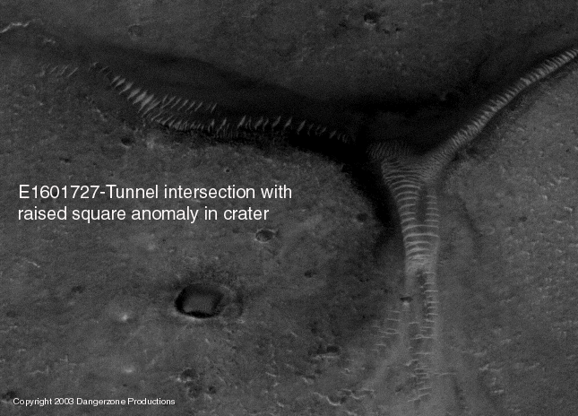
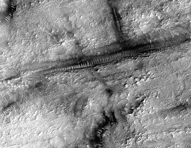
MOC image E160127 contains another
of these junctions, precisely showing Lowell documented in the 1890's, complete
with the rectangular anomaly akin to what Lowell was said to have observed directly
adjacent to the larger canals. Traversing Mars just below it's shifting sands,
two mighty conduits plunge deep below the regolith to an underworld John Carter
would have been keen to traverse. All locations where we observe these "Glass
tunnel" anomalies are heralded by a series of unusual crater morphologies
as seen in image strip M15-01228 and others,
where numerous convex anomalies resembling domes were apparent in craters directly
adjacent to the tunnels. In this craters center is a raised square, looking
for all of Mars like some large circus tent or sports coliseum with an inflatable
roof.
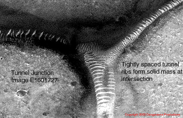
A contrast enhanced crop of this Martian
Cloverleaf gives us our first good look at one of these arterial intersections.
Assuming these "ribs" are load bearing structures, one can see a the
spacing between the ribs grow narrower as the tube approaches the junction,
forming what is essentially a solid mass at the epicenter, reminiscent of the
solid mass of tunnel roof seen directly adjacent to the "Oannes" effigy
in image M15-01228.
MOC image E160127
Image Courtesy of Eric C. Lausch
©2003 Dangerzone Productions
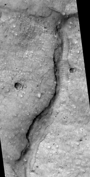
Following this tunnel down the image strip
as it circuitously meanders to its apparent disappearance at the ice field of
a nearby crater, one ponders what significance this holds. Indeed, numerous
images of these tunnel systems appear to originate or terminate in the vicinity
of large craters with lots shiny patches (presumably rime ice), a possible indication
of nearby liquid water under the surface of Mars. It takes no great leap of
faith to imagine Lowell touting this as evidence of his hub and spoke system
of canals with the canals providing vital resources to in the form of water
to desert oases located in the crater basins. Over and over we see the coils
of this phenomenon directly adjacent to large shiny craters resembling a high
mountain lake which stays perpetually shaded, frozen over in the the Martian
climate. One also notes that the large crater nearby seems to have a polygonal
shape inscribed in it's bottom.
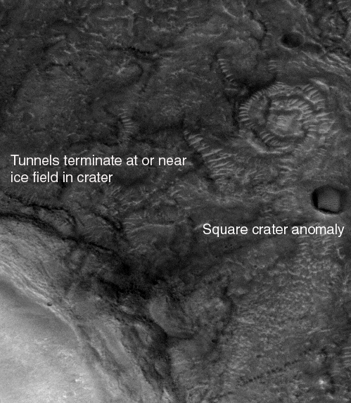
Crop of MOC image E160127
©2003 Dangerzone Productions
Planetary geologists suggest that Martian aquifers are composed of porous lava rock with areas of sandstone and limestone present. All are excellent aquifer materials and would allow the Martian aquifers to hold large amounts of water. A team from the University of Arizona has gone as far as suggesting a network of natural underground "pipes" that can transport water easily from one place to another. According to theory, these "pipes" are created when the brittle lava rock fractures or a space rock impacts the surface. The fractures act like a interstate system for the water, providing ease of movement throughout the aquifer. This "glass tunnel" phenomenon would certainly prove a viable explanation for these "pipes", allowing free movement of water throughout the Martian aquifers.
MOC Image E1200479 illustrates another of the multiple tunnel junction showing a minimum of five tubes in this area. This area is unique thus far, in that it reveals a 90 degree or perpendicular joining of these anomalies. This is the first good visible indication of this type of engineering design, which is suggestive of construction methods of utilized by intelligent beings. As seen in numerous examples of this Martian infrastructure, this tunnel section eventually appears to terminate/originate at an enormous, bright crater, perhaps the site of an ancient body of water. Perhaps these bright craters were once the "nodes" of Lowell's canals, reservoirs of water diminishing steadily as Mars resources disappeared.
MOC Image E1200479
Image courtesy David Jinks and Dr. Paula Sommerville
Special thanks to Dr. Michael Malin and Dr. Kenneth Edgett
MOC image M0201270 is officially described
as "Giant polygons in Acidalia Planitia". The details of the tunnel
remnant shown here is really quite stunning in the full size image strip. This
crop covers an area around 4 km long. The canal itself approached .75 km in
width at the widest spots visible. Apparently from the official description
of this image our friends at MSSS found the polygonal shapes enclosed in the
craters as being the most noteworthy items in this area. Once again we find
unusually shaped craters or basins directly adjacent to the "glass tunnel"
anomalies. As Lowell and others have noted of the Midwestern earthworks of North
America, intelligent design is the most plausible explanation for such geometric
shapes cut into surface of Mars.
Giant polygons-MOC image M0201270
Image Courtesy of John Levassuer
Longitude of image center: 28.35¡
W Latitude of image center: 38.98¡N
3.07m/pixel
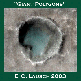
Image courtesy Eric C. Lausch
©2003 Dangerzone Productions
Directly across the channel from the smaller polygon is a free standing outcropping, apparently separate from the channel boundary. Similar to the outcropping seen in MOC2-550 (Aram Chaos) where we saw the "sedimentary" looking ruin of a collapsed tunnel and fractured translucent material littering the area. Possibly this is a remnant of a semicircular support structure or pressure hull that once covered the channel area and has since succumbed to the ravages of Mars.
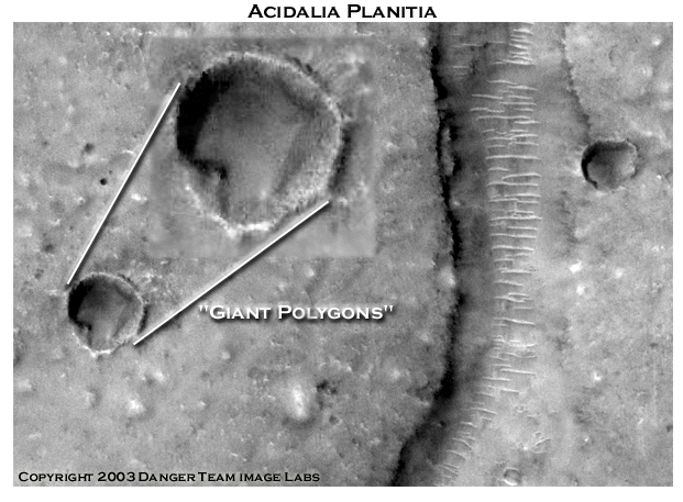
Image courtesy Danger Team Image
Labs
©2003 Dangerzone Productions
Gamma ray spectrometer data shows a high incidence of groundwater in this locale. Acidalia Planitia is situated on the periphery of the "great yellow spot" we noted in the GRS map earlier. It is also very near to where Lowell recorded one of the largest hubs of his canal system. Lowell drew huge canals running through this area in 1894. Thus far this area has tunnels, unusual craters and a high incidence of groundwater. A pretty good start per Lowell and his statistical theory which utilizes sets to confirm a hypothesis.
After having found indications of three of our four primary "classes" of objects (the tunnels and their strange craters) in Acidalia Planitia, the stalwart anomaly hunter plods on, tirelessly downloading image after image in hopes of locating some of the other "classes" of objects related to the tunnels. New data comes in and fresh discoveries are made. We struck paydirt with Themis data release V03945003, a recent data acquisition from the Acidalia Planitia region.
Without writing a tutorial on the THEMIS, suffice to say it take images in various spectral bands, one of which is what we humans call the visible light band. It has been suggested that the areas of high albedo in the Themis visible light images is indicative of the presence of intelligently fabricated materials that differ from the surrounding terrain. In the article "The light finally dawns on Cydonia", Richard C. Hoagland discussed the idea that this shiny material was some sort of highly reflective polymer or glass used for structural applications on Mars. Typically, Themis visible light images have numerous areas of high albedo.
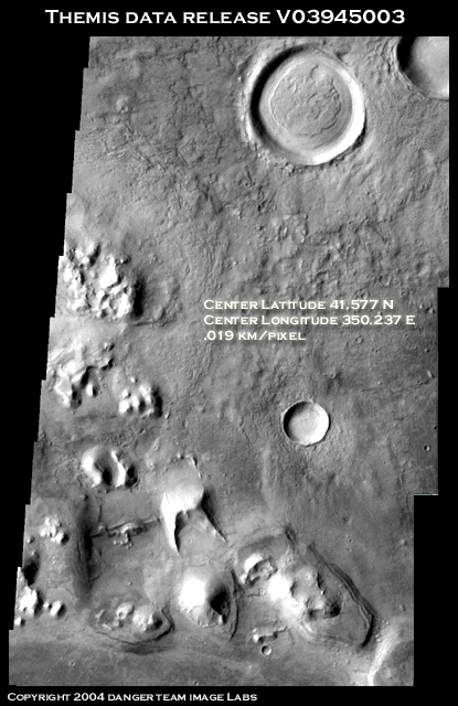
Themis data release V03945003
Special thanks to Gary Leguerrie
.019 km/pixel
Volia!! Acidalia Planitia has surface structures! The entire area smacks of intelligent design. The scene is dominated by a huge pyramidal structure that has a large icon, shaped something like a candy cane affixed to it's front side, analogous to a crucifix adorning the front of St. John's cathedral. This icon is to my knowledge the first good example of symbology associated with any anomalous structures on Mars. Its like hanging a sign out front. A propitious moment indeed.
To the right of the pyramid is a large fortress-like building fronted by high walls. The arched central section appears to have a large set of steps running from it down to the ground (yes, I said steps)! Looking like a cross between the Alamo and some ancient Egyptian temple, this structure is so terrestrial in appearance that it must have been designed for use by beings not unlike ourselves. Located to the fore and rear are two large domes. The roof of the dome to the rear appears to have collapsed (similar to the collapse on the right side of Cydonia's Face) and two large holes can be seen in it.
The dome in the foreground is intact and has a large entrance with some small structures just inside the doorway. Several large mounds can be seen, possibly buildings covered with layers of Martian dust. The large rise to the left of the fortress also seems to have a cavernous opening in its side. Unlike the ambiguous structures of the Cydonia Mensae area, the Acidalia Planitia complex has clear features, with right angle turns in the outer walls and a classically arched roof fronting its entrance.
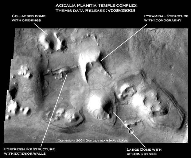
Acidalia Planitia temple complex
©2003 Dangerzone Productions
Special thanks to the University of Arizona THEMIS team
The Pyramidal structure is immense, measuring 2800 meters by 3200 meters with the front legs protruding almost 1300 meters from the base. The cane shaped icon displayed on its surface is approximately 400 meters tall. The height of the pyramid at the apex is just short of a kilometer.
The exterior walls of the fortress measure
almost 3500 meters with an average height of 360 meters. The arched entrance
is 475 meters high. The staircase measures over a half a kilometer in length.
One can only guess at the immense size of the buried structure behind the entrance.
The collapsed dome to the rear at one time measured in at around 2.2 kilometers
in diameter. The openings in it's side are around 700-800 meters.
One would be hard pressed to quantify a
geological process that could produce such disparate geometric morphologies
in such a relatively small geographical area. This complex must be the product
of some long forgotten race of builders. This is an exo-archaeologists dream
dig. Please write your congressman about this one! Even an MGS wide angle image
of this area at 4m/pixel would reveal a significant increase in detail when
compared to the 19m/pixel resolution of the Themis visible band image. Interestingly
enough, there is only a visible band image of this area available. None of the
other bands are accessible from the Themis website. Our understanding is the
images from the different bands are created simultaneously. If so, then why
is only the visible light image available for this area? Perhaps the Mars Reconnaissance
Orbiter can live up to its name in Acidalia Planitia with an image clear enough
to see the individual steps leading up to the entrance. Now there'd be some
reconnaissance!
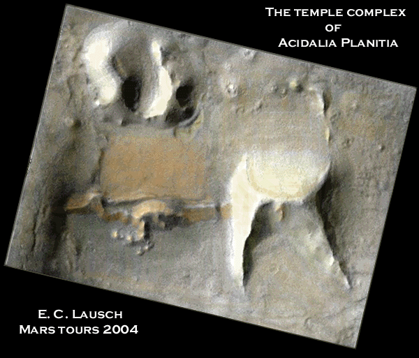
Image Courtesy of Eric C. Lausch
©2003 Dangerzone Productions
The intact dome to the front of the pyramid
measures in at almost 2.5 kilometers in diameter. The opening in it's side
is
over a kilometer. Some type of structure can made out around and within the
opening, looking like ramps leading down into a bowl for seating. Vaguely
reminiscent
of a domed sports arena, one can almost envision excited Martian fans waving
terrible Martian towels or engaged in some Martian version of the Tomahawk
chop.
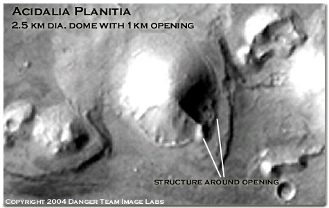
The dome at Acidalia Planitia
©2003 Dangerzone Productions
That makes three of our 4 classes of objects now located in Acidalia Planitia. Spurred on by such discoveries, the stalwart anomaly hunter scours the area for the signs of the the fourth set in our theory, large scale effigies or landscape art. Upon perusal of the entire strip one sees a number of perfectly round, large diameter craters. As so many of the so called "craters" in Mars imagery have unusual shapes which are anything but circular the makes roundness of these craters seem quite beautiful. All save one, appear to have homogeneously smooth, shiny bottoms.
The large crater just north of the temple complex is approximately 11 kilometers in diameter and has a raised structure around 7 kilometers across in its center. What geological process could account for this one crater internal structure to be so radically estranged from it nearby neighbors? None spring to mind. Intelligent intervention seems more plausible a cause.
Now this may seem a stretch to you right
brainers with no imagination. However, numerous left-brainers report seeing
a bas relief effigy of a bird of prey stamped into the crater basin like a megalithic
scale twenty dollar gold piece on the face of Mars. Covered with a thick layer
of Mars dust, some fine details such as the feathers at the crest of the head,
eye socket and nostril can still be made out.
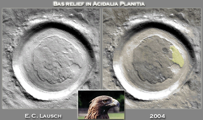
Image Courtesy of Eric C. Lausch
©2003 Dangerzone Productions
As to the significance of the avian effigy one can only speculate. Perhaps the Martian football team was called the Eagles. In keeping with the Martian zoo scenario perhaps this was a bird sanctuary with the domed structure serving as an open air aviary similar to the large screened in walk through aviaries found in metropolitan zoos.
With all of our "classes" present and accounted for, Lowell's theorem would put the odds of Acidalia Planitia having artificial constructs at 300 to 1.
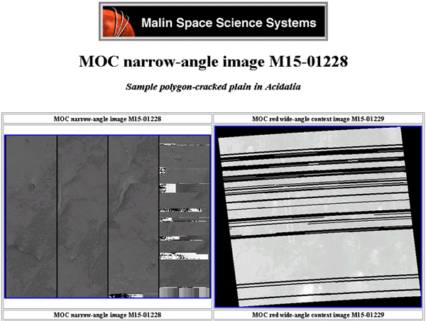
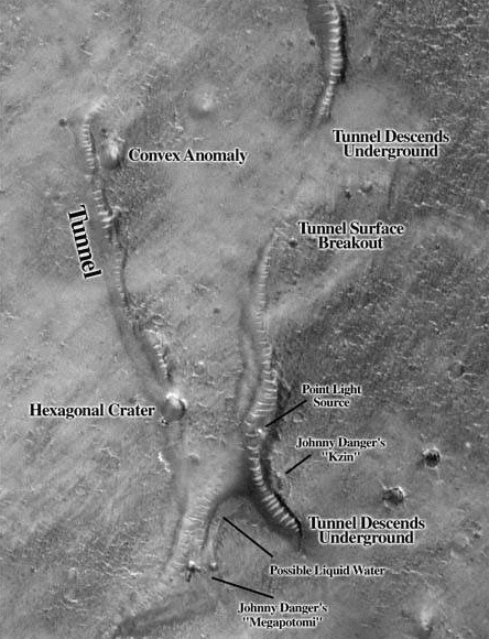
Another area of high strangeness in Acidalia can be found in orbital image strip for Mars Global Surveyor Orbit M15-01228. This image shows a complex network of interconnected tunnels just below the regolith along with numerous surface anomalies such as the "Oannes" effigy at Grand Central which we saw earlier along with extremely large domes which appear act as hubs or nodes for the tunnels.
As a caveat to that we state that for one of the most interesting images from Mars, for some reason it got the worst possible presentation from MSSS. As with the poor presentation of MOC E04-00863 and it's "Lowell Tunnel Complex", rather than presenting it as a strip, which is the norm, M15-01228 is tiled. This make it difficult to see the overall relationships between the tunnels, the "Oannes" effigy and the domes. The extremely dim image is not properly processed. The wide angle image is even worse. It might have proven useful in determining the scope of the overall tunnel system. One has to go to the USGS site to get a properly processed strip presentation of M15-01228. While not to suggest a full blown deception in this case it does seems highly coincidental that such an interesting image is displayed so poorly for public perusal. Combined with the fact that it's closest counterpart with regards to surface anomalies is the only other area in Acidalia to be processed in this manner suggests this was done at the behest of someone within MSSS/JPL/NASA who wished to downplay these images and limit public discussion on these matters.
A crop from the strip is shown below.
The entire annotated image strip "The
Big Picture" can be found at: http://www.geocities.com/photon9999/bigpicture.htm
.
Crop From Mars
Global Surveyor Orbit M15-01228
Image courtesy of J. Danger & Kevin Klettke
©2001
Dangerzone Productions
With all the strange features in M15-01228
we had little previous comment on these smaller effigies other than to note
their existence by labeling them the Kzin (ala Larry Niven) and the Mega-potami.
In comparison to the half mile high Oannes effigy just north at Grand Central
these artifacts are of a more terrestrial scale, something more akin to the
size of large Egyptian effigies found at ancient temples. We mention them here
as we have raised the issue that artifacts on this scale will ultimately force
the decision on artificiality as we image them with high resolution cameras.
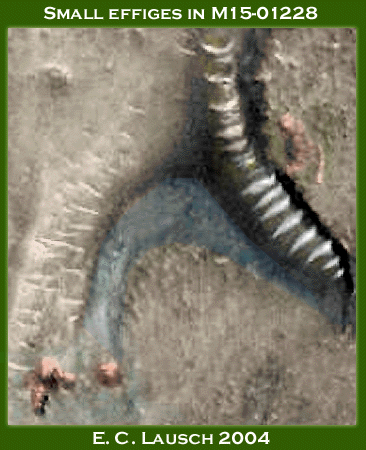
Image Courtesy of Eric C. Lausch
©2003 Dangerzone Productions
The Kzin towers above the tunnel as it disappears beneath the surface. The megapotami do look rather like two hippos basking in shallow water. One could almost imagine these as animatronic props on Universal's Jurassic Park adventure ride, partially submerged until a passing boat arrives, then quickly rising to shower excited children with water. You zoology buffs will be glad to hear that the hippo is the closest terrestrial relative to the whale. We do hope you get familiar with them as you'll see something very similar again later.
Just south of our small effigies the tunnel
in M15-01228 resurfaces and runs topside for some distance before submerging
beneath the surface once more. The handsomely processed gif file below comes
to us courtesy of Keith Laney. The glass tunnels translucent quality and distinctive
"riblike supports" are a stark contrast to the surrounding terrain.
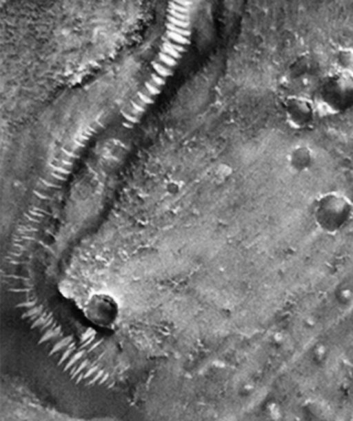
Crop of M15-01228
Image credit: Keith Laney - 2000
This shape from shading (SFS) of the area
serves to verify the three dimensional aspects of the glass tunnel phenomenon.
Created from algorithms that compare relative levels of albedo (light vs.
dark)
this 3-D rendering shows our section of tunnel to be a raised structure that
runs just above the surface of the channel prior to submerging below the
ground.
This would seem to support our contention of surface structures that have slumped
or been covered with debris over long periods of time resulting in their
eventual
inundation. If as JPL purports, these are simple dune trains formed in channels
they would not stand up above the surrounding terrain so dramatically.
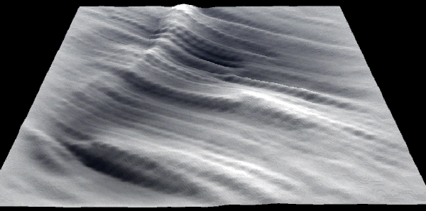
Shape from Shading for crop of M15-01228
SFS courtesy of Chris Joseph - 2000
"Now it will be noticed that these shapes are as unnatural as they are definite, and that they all agree in one peculiarity: they are all convex, not concave, to the entering canals. They are not, therefore, mere enlargements of the canals, due to natural causes; for, were the spots enlargements of the canals, at their crossing-points they should be more or less star-shaped, or concave to the canals, whereas they are round, or roundish rectangles,--that is, convex to the same. Such convexity negatives, at the outset, their being purely natural outgrowths of the canals."
-Percival Lowell
Further investigation has revealed that MOC image M0702589 has another of the immense geodesic "dome" type structures which we catalogued two of in MOC image strip M15-01228 and discussed in the article "Is this an Artificial Construct on Mars?". For all intents and purposes these objects are identical in size and surface characteristics with their characteristic "golfball" like surface texture. The glass tunnels anomalies appear to connect directly our "domes" in MOC image strips. Again it becomes apparent that we are seeing a particular "class" of similar objects upon the surface of the angry red planet. The high incidence of such unusual crater morphologies directly adjacent to our "glass tunnels" must surely imply some type of systemic relationship exists between these fascinating structures seen standing watch on each other and the surface of Mars. Shown below is a comparison of these three "domes" which are so similar in design or nature. They are approximately twice the size of the dome at Epcot Center in Florida.
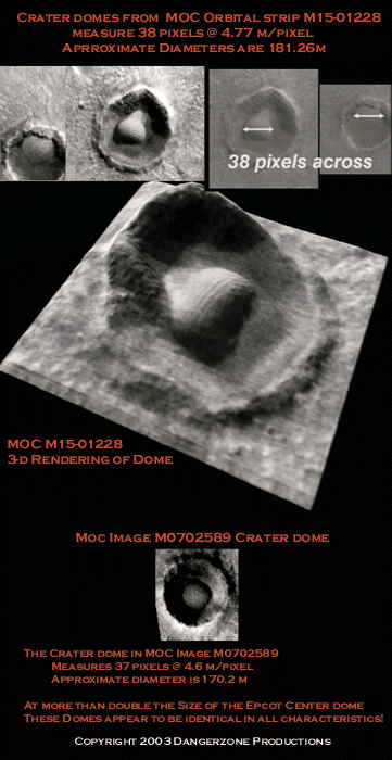
Comparison of crater domes
Image courtesy of Chris Joseph and Eric C. Lausch
©2003 Dangerzone Productions
What possible explanation suffices for these domes so intimately associated with the Martian tunnel system and the Acidalia Planitia region? The gamut runs from possible intelligently designed arcologies and water reclamation plants to lava domes or possible alien plant life. Whatever the explanation, one cannot deny the high incidence of such anomalies adjacent the Martian tunnel system. As our glass tunnel anomalies appear to run directly to these immense domed structures, they look hauntingly familiar when compared with Lowell's plates detailing Martian canal system.
My guess is our old friend Lowell
would have been connecting the dots in regards to all this revolutionary data
available today about Mars. Or more likely, perhaps that's precisely what he
did during the 1894 opposition. Perhaps Lowell and others saw a sort of planetary
autumn on Mars back then while we now study the Martian winter with our orbiting
probes a century later. What marvels might the Martian springtime reveal?
The "canali" or glass
tunnel anomalies can be found in over two dozen MOC images thus far and we've
mapped barely three percent of the Martian surface since 1997 when MGS commenced
it's primary mission. An interesting fact is that MSSS has taken an inordinately
high numbers of images in and around the Cydonia Mensae and Acidalia Planitia
region. This is partly because of public interest generated by the Face as well
as the the FACETS litigation which force the re-imaging of the the Face at Cydonia.
However, it seems almost as if there is some clandestine interest at MSSS in
this geographic vicinity as the number of images for this region is quite high.
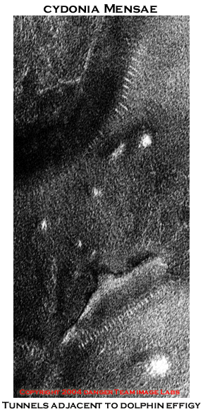
Image courtesy Danger Team Image Labs
©2004 Dangerzone Productions
The fact that these anomalous structures are found geographically adjacent to the Face and city proper is in itself an added dimension to this mystery. McDaniels "Coathanger" anomaly which in profile resembles a dolphin has a series of parallel striations running along it's length. Large scale effigies, as well, appear to be closely associated with this phenomenon. Statistically, we'd bet that we'll see a lot more of these things as we image the areas between 28 and 40 degrees north latitude, especially the area west of the Cydonia Mensae region. After all, Lowell saw them there. And elsewhere, I'd wager, at say, 300 to 1 odds.
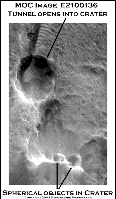
Image courtesy Danger Team Image
Labs
©2003 Dangerzone Productions
MOC Image E2100136 reveals one of our tunnels opening up directly into a basin. Rather than becoming preoccupied with the size of the tunnel mouth ( it's around 60m-70 m) I ask you to direct your gaze just south to the two large bulbous "things" perched atop the crag directly adjacent to the canal entrance. These "eggs" have a distinctly "biological" quality about them.
Again we ask, "Just what the heck is
that?" Looking for all of Mars like some Martian Mega-puffball just waiting
for the right impetus to release it's spores and initiate Schiaparelli's process
of "Gemination". These artifacts stand over a hundred meters high
from the scarp of the crag. One wonders what possible type of sand dune these
may turn out to be. Lowell's intimation that the canals deliver water to oases
to sustain life seems quite plausible when considered in this light. Like the
"Dalmatian spots and the south polar "trees", most likely this
is indicative of some type of life form. The possibilities range from enormous
Martian puffballs to giant alien mega-spider sacs. Or mayhaps it's naught but
an egg shaped sand dune.
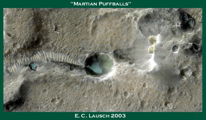
Image Courtesy of Eric C. Lausch
©2003 Dangerzone Productions
Near the very bottom of strip E2100136 we find a small basin containing intricate internal details. To the casual observer one sees a crater with what appears to be a series of gently curving ramps or walls arcing down from the rim.
An individual of Percival Lowell's disposition
would have little trouble explaining this image. "A waterfall exits at
twelve o'clock beneath the rim crashing down into the breakwater one can see
arcing in from the one o'clock position. After hitting the breakwater, the churning
flood backwashes through the opening to the left, filling the large standing
pool before cascading through the narrow openings between the ramparts down
to a second, lower pool at the two o'clock position. From the lower pool the
precious liquid is returned to the underworld via the dark opening at the basins
edge. A second spillway can be seen entering just above three o'clock followed
by a series of smaller sluices".
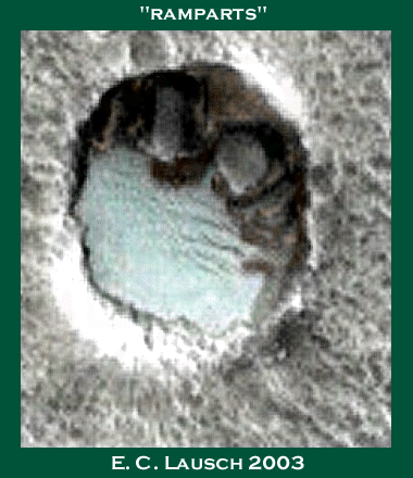
Image Courtesy of Eric C. Lausch
©2003 Dangerzone Productions
That makes for a pretty picture. Very soon we'll have definitive answers on the presence of liquid surface water on Mars and beneath it. Time and continued research will tell the tale. The large, gently moving pool of water would provide an excellent location for contaminants and particulates churned up by the waterfall action to settle to the bottom, providing fodder for whatever Martian bacteriological denizens that might frequent this spot. Not unlike the filtration pools once sees at a typical urban water treatment plant. Lowell would chalk this up as yet another tertiary appendage of the much larger infrastructure for Martian water management.
At the northern border of Acidalia MOC M1500835 sports what to
date appears to be the largest relatively intact section of Lowell's tunnels.
The image is terribly underexposed having been targeted with a combination of
gain and offset mode parameters that render it practically unviewable. The section
of tunnel imaged is over 600 meters wide. The crop is approximately 3.2 kim
wide. Two large surface structures can be seen near the junction of the two
forks. The distinctive banding of the ribs appears fractured and disjointed,
possibly indicating a state of partial collapse of the tunnel canopy.
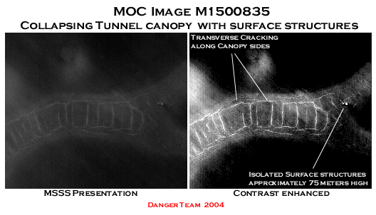
Bright ribs in northern Acidalia
©2004 Dangerzone Productions
Image strip after image strip
we see myriad examples of an interconnected system of underground conduits
which
are directly tied to large surface structures, domes, effigies or intaglios
and a plethora of unusual craters or basins which show possible openings
from
which gain access to the tunnel system. Closer examination of these basins
seems to indicate some type of structures inside many of them. Nearing the
limits
of our resolution capabilities, these areas may
hold some surprises for the Mars Reconnaissance Orbiter in 2005. The very
name,
Mars Reconnaissance Orbiter seems to imply gathering intelligence, as in surveillance
of a foreign power. If indeed there really are such edifices on Mars as these
images seem to imply, real proof of intelligent design should begin to appear
as the MRO's superior imaging capabilities allow for closer inspection of
fine
details (provided we can get NASA to target them in the first place). This
would provide for analysis of items in the range of the surface structures
apparent
in M1500835.
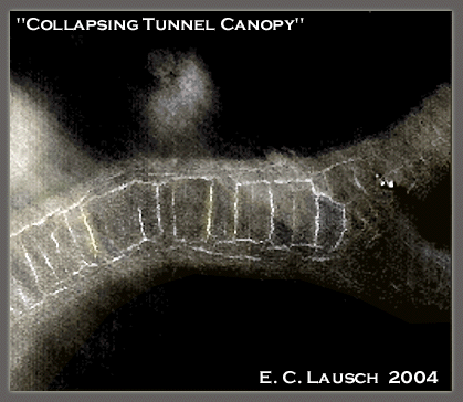
Image Courtesy of Eric C. Lausch
©2004 Dangerzone Productions
Currently, the prudent action to take is to continue to examine and document imagery of such curious nature with hopes of petitioning NASA and the ESA into analyzing these areas in greater detail using it's their newly acquired radar, spectroscopic and color imaging capabilities.
Until that happens, a picture's worth a thousand words. In our next section we will examine MOC strip from E0101630, an astounding image which exemplifies the artificial nature of this alien infrastructure that Lowell envisioned so long ago when planetary science was in its infancy.