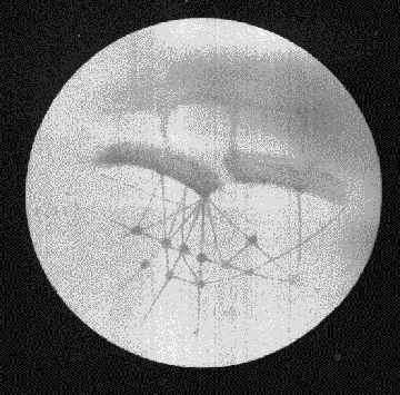
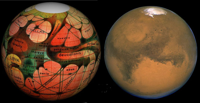
Lowell's "Canals"
Canal Map courtesy of Percival Lowell
Special thanks to Richard C. Hoagland
© 2004 Dangerzone Productions
Lowell's Legacy- Part two - What constitutes proof?
"The next point is as to what constitutes proof. Now, between the truths we take for granted because of their age, and those we question because of their youth, we are apt to forget that in both proof is nothing but preponderance of probability. The law of gravitation; for example, than which we believe nothing to be more true, depends eventually, as recognized by us, upon a question of probability; and so do the thousand and one problems of daily life upon so many of which we act unhesitatingly and should be philosophic fools if we did not. All deduction rests ultimately upon the data derived from experience. This is the tortoise that supports our conception of the cosmos. For us, therefore, the point at issue in any theory is not whether there be a possibility of its being false, but whether there be a probability of its being true. This, which is evident enough when squarely envisaged, is too often lost sight of in discussing theories on their road to recognition. Negative evidence is no evidence at all, and the possibility that a thing might be otherwise, no proof whatever that it is not so. The test of a theory is, first, that it shall not be directly contradicted by any facts, and secondly, that the probabilities in its favor shall be sufficiently great."
-Percival Lowell
Lowell sounds as if he wrote this during the last week rather than before the last century. Things change yet they still remain the same, such is the human condition. After this quote Lowell goes into a long diatribe on the statistical nature of mathematical sets. I include it as a matter of some interest as we will attempt to apply Lowell's theory of mathematical sets to our current analysis. He explains statistically how the observation of similar sets (anomalies or objects of the same "class") had the effect of increasing the statistical probability of a particular theory being true multiplicatively rather than additively. In other words, after one has hypothesized a theory, the greater the incidence of complimentary proofs that one documents, the greater the probability that the theory is correct. This effectively raises the odds by orders of magnitude quite rapidly providing one can prove his ideas correct. I'm curious to see how high the Lowell's bookies will go on this one.
We will refer to Lowell call sets as "classes" of objects, each with their own details. According to Percy, we should attempt to see if the explanation of one set compliments the subsequent explanation of the next set, as I understand it. In other words, observe, document and theorize. A sound basis for researchers.
"As to what constitutes sufficiency it is important to bear in mind one point, namely, that the odds that a thing is true from the fact that two or more witnesses agree on the same statement is not the sum of the odds that each tells the truth, but the product of those odds. Note (See Lacroix, Traite Elementarire des Probabilites, p. 220) Therefore, if the chances for the truth of a theory, in consequence of its explaining a certain set of details, be three to one, and because of its explaining another set,--for the purposes of argument unrelated to the first,--four to one, then the chances in its favor from its explaining both sets are not seven to one but twelve to one. If it explains a third set whose independently resulting odds are of five to one, the chances in its favor, from its explaining all three sets, not twelve to one but sixty to one; if a fourth set be added, with further odds of five to one, the sum total from the four becomes not seventeen to one but three hundred to one in favor of its being true. It will be seen how rapidly the probability of the truth of a theory mounts up from the amount of detail it explains. This law is to be remembered throughout the coming exposition, for whatever the cogency of each detail of the argument in itself, the concurrence of all renders them not simply additionally but multiplicitly effective. That different lines of induction all converge to one point proves that point to be the radiant point of the result."
-Percival Lowell
Three hundred to one! I wonder what the odds on nine sets of details works out to be?
Lowell's sets or "classes" of interrelated objects for the purpose of this argument will be:
Our hypothesis is as follows:
Current observations and data from Mars support the contention that what Percival Lowell and others documented in the nineteenth century was an intelligently designed planetary infrastructure for water management, parts of which are still intact and may be functioning. Any geographically adjacent, culturally significant artifacts falling into our "set or class" definitions will be deemed to represent a primary, secondary or tertiary truth in support of this hypothesis. Our intentions are to present evidence gleaned from imaging and other data that will support this hypothesis.
OK. Let's go for the biggies (#1 and #4) right off the bat. Our entire grubstake rides on this one. If it won't pass muster we might as well pack it in. Lowell contended that the canals were built for the purpose of irrigation. An intelligent utilization of vital resources required for the survival of a sentient species. Is there a demonstrable relationship between Lowell's plates and current planetary data regarding Mars water resources?
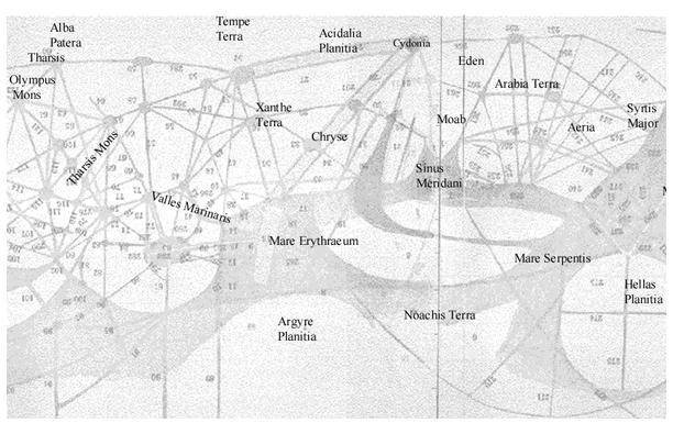
In order to establish this a short tutorial on Lowellian Mars geography is essential. Utilizing Schiaparelli's naming conventions which had become standard terminology, Lowell produced detailed maps of the Martian canal system. Every numbered location had a classical sounding name which enamored the public. His speculations ran from Martian civil engineering projects to Martian politics. Ironically, such issues are inevitably linked no matter what the era one lives in. Lowell was once again ahead of the curve, inquiring about the anthropological nature of another intelligence other than humankind.
Lowell writes of his map:
" a map made upon what is called Mercator's projection. Mercator's projection I take to have been primarily an invention of the devil, although commonly credited to Mercator. It is not simple to construct and for popular purposes is eminently deceitful. It is intended for those at sea, whom we pray for on Sundays. It is certainly calculated to put any one entirely at sea who attempts to learn geography by means of it. Its object is to enable such as wish to do so to sail upon rhumb lines, a rhumb line upon a sphere being one which never changes its direction,--one, for example, which runs perpetually northeast one quarter east, or south half west. These lines, important in navigation, are in reality diminishing corkscrew-like spirals, but on this projection become straight lines which can be instantly laid down by rule and compass. To make such delineation possible it is necessary to distort the proportions of every part of the map, in increasing divergence toward the poles, with the lamentable result that in early life we all believed Nova Zembla to be a place as big as South America. Nevertheless Mercator's projection has certain advantages not so obvious to the uninitiated, nor requiring special mention here. In this connection it is only necessary to warn the reader, in the case of a geography with which he is not familiar, like that of Mars, to remember that the top and bottom of the map are drawn upon a scale three or four times as large as the middle; and, furthermore, that it is a consequence of Mercator's projection that arcs of great circles appear upon it, not as straight lines, but as curves always more or less concave to the equator. For relative size of the various features, he will find the twelve views from the globe accurate; but for the impressiveness of the great circle character of the canals, nothing short of a globe itself will give him adequate realization.
-Percival Lowell
Lowell once again is demonstrably cogent
in his analysis. A Mercator projection may indeed be the progeny of the devil.
Like Lowell, we pray for those at sea on Sundays
but must admit to agreeing with Lowell on Mercator projections. The foray into
cartography was admittedly educational.
.
Lowell's "Canals"
Canal Map courtesy of Percival Lowell
Special thanks to Richard C. Hoagland
© 2004 Dangerzone Productions
Armed with the best telescope known to contemporary science Percival
Lowell sketched what other astronomers had only intimated in their cartographic
efforts. A coherent infrastructure for directing planetary water reserves. He
hypothesized that the patterns he documented were the product of intelligent
beings. It follows then that if Lowell was correct we should then find artifacts
of the aforementioned intelligence in areas geographically adjacent the canals,
hubs or nodes of Lowell's infrastructure, in effect turning Lowell's sketches
into a Martian treasure map. The key to an extraterrestrial Valley of the Kings,
in a manner of speaking.
Lowell's canals
Image Courtesy of E. C. Lausch
© 2004 Dangerzone Productions
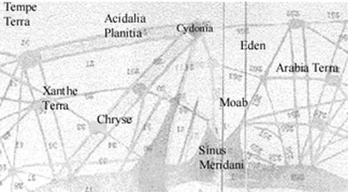
Interestingly enough, Lowell's "canals" directly intersect and encompass such areas as Cydonia, Acidalia Planitia , Chryse, Xanthe Terra, and the Hellas basin. All have been the subject of spirited debate with regards to unusual landforms which have been conjectured to be evidence of an ancient civilization on Mars. Finding such artifacts so closely related to Lowell's sketches tends to support the idea of intelligent intervention on Mars.
Common sense says that the Mars of our great grandparents is the Mars of today - after all, one hundred years is only a small snippet on a geological scale of time. Comparing the Mars observations of 19th century to contemporary Mars data would seem the logical place to commence such a journey down the path less taken.
Overlaying Lowell's canals on a modern greyscale map of Mars
confirms that Lowell was indeed looking at a Mars not far removed from our
own. The dark
swaths of plates 24a and 25b align precisely over the tonal variations of our
modern maps of Mars. The northwards facing forks of Meridiani and desolation
of the Hellas basin brook no misgivings in support of this interpretation.
Lowell's canals look right at home in this image of Mars. That Lowell and
Schiaparelli
could record the surface detail of Mars so accurately suggests they may have
seen some actual process at work on the surface of Mars in the nineteenth
century.
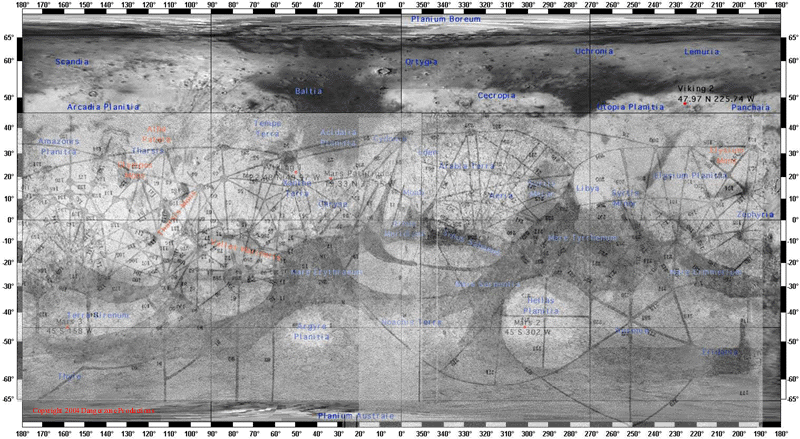
Image courtesy of NASA / JPL / Lowell Observatory
Composite by J. Danger
© 2004 Dangerzone Productions
Both Lowell and Schiaparelli postulated the markings were inextricably
linked with water resources. If true, then this process should show some intrinsic
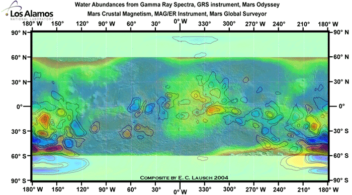
relationship with groundwater. Utilizing modern Gamma
Ray Spectrometer data we have created an overlay of Lowell's detailed renderings
from 1894 for comparison against current knowledge of Mars water resources.
As I have no training in cartography I will brook no excuses as to the accuracy
of this endeavor. However, from my reading I will assume that the areas from
40 degrees north to 40 degrees south are in fact accurate enough in detail to
beg no inquiry as to their applicability in this case.
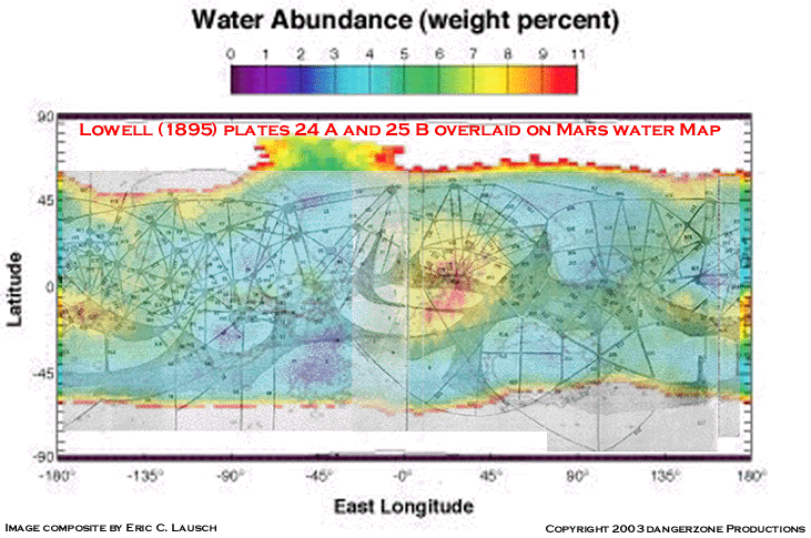
Lowell compared to GRS data
Image courtesy Percival Lowell and Eric C. Lausch
GRS data: NASA/JPL/MSSS
© 2004 Dangerzone Productions
Here's a short tutorial for the layman on interpreting GRS data:
| Red: Positively dripping with water. Look for bodies of surface water if they exist. The Martian equivalent of the Everglades. Large underground aquifers to exist in these areas. |
| Yellow: Water table adequate for sustaining life without heroic measures. Underground aquifers. |
| Green: Drill a well. |
| Blue: Arid expanses similar to eastern Washington. A breadbasket of fertility when irrigated. Water management is a priority. |
| Violet: Death Valley, Giza or Albuquerque. Water use is subject to stiff penalties and double secret probation. |
In a nutshell, red, yellow and green are the areas most hospitable to life on Mars today with regards to available water resources.
Upon initial inspection of this melding of information
born a century apart, it becomes apparent that what Lowell and other researchers
recorded in the 1800's was indicative of present day ground water resources
on Mars. Lowell's plates could easily have been the product of an artist using
GRS (gamma ray spectrometer) data as the baseline. Dense
networks of canals in the wet areas connect to large nodes the dry regions.
As well as providing valuable insight into the nature of our sister planet this
overlay appeals to the eye with a degree of order normally found only in an
large scale civil engineering project.
Lowell compared to GRS data
Image courtesy Percival Lowell and Eric C. Lausch
GRS data: NASA/JPL/MSSS
© 2004 Dangerzone Productions
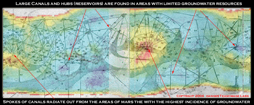
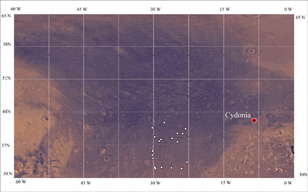
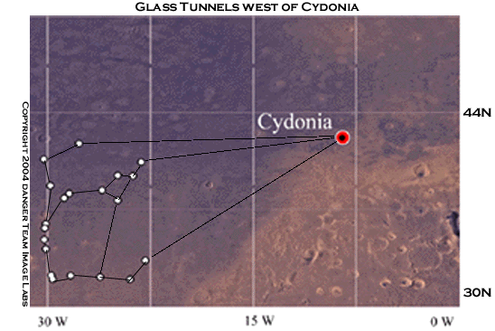
Please direct your attention to the large yellow and red spot just left of center of the map at Meridiani. One hundred and eighty degrees around the orb one finds Gusev near Elysium. This is the other area of highest concentration of water resources on Mars. These areas are obviously among the likeliest spots to search for life on Mars. Meridiani also happens to be geographically adjacent the regions of Mars where the most intriguing of images come from. Cydonia and easily 90% of the images analyzed (and virtually all of the glass tunnel pictures) in this piece are found adjacent to the canals Lowell depicted as having originated in Meridiani. For simplicity's sake we shall henceforth refer to this area as the "Great Yellow Spot" of Mars. This region is one of two major nexii for Lowell's hub and spoke system of canals as documented in the 1890's.
As Lowell and Schiaparelli had no way of determining the extent of groundwater resources on Mars can it be mere coincidence that both selected these locations as the focal points for their theories on Mars, both of which are inextricably linked to water resources. The odds on this are slim. This selection of these two water rich locations supports the contention that what Lowell documented on Mars was an actual process taking place there during his lifetime and supports an intrinsic relationship between the canals and groundwater resources on Mars today. Drawing the canals as spokes radiating out from these large aquifers they eventually connect at large circular hubs which may have indicated some type of reservoir or arcology. If one was to design a system for managing Mar's planetary water resources many facets of it would parallel Lowell's canals in form and function. One would pump water from the wet equatorial regions to areas with low groundwater resources. This is precisely what Lowell has depicted - without any way of knowing that his canals originated in the wettest areas of Mars. Is this coincidence - or something more? It is also interesting to note this region has a large areas of magnetic anomalies associated with it as well.
Keeping in mind that these overlays are only a tool to help define overall trends between different renderings, we have overlaid the canals on different projections of Mars and it's hydrogen resources. They do seem to show trends between the canals and available groundwater resources. The inherent beauty of this concatenation of scientific data will, for this author, suffice in it's clarification that what Lowell and Schiaparelli documented was indeed directly related to water abundance on Mars. His ochre fields mimic the vast expanses of the southern highlands. Much of Lowell's "hub and spoke" system falls directly upon the highest areas water resources, with large canals running from these central nodes to areas of the planet where we find little evidence of water today, effectively connecting the high water resource areas to the more arid locales. Beautiful to behold, it may portend but mere coincidence. This author, for one, finds the coincidental supposition dubious at best and believes it to represent actual visible changes in the appearance of the surface Mars that were discernible to telescopic scrutiny for several decades during the nineteenth century. Thus, in our opinion the relationship between class #1 (water) and Class #4 (canals) has been established.
"To review, now, the chain of reasoning by which we have been led to regard it probable that upon the surface of Mars we see the "effects of local intelligence".
-Percival Lowell
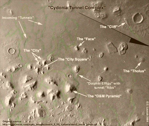
Cydonia
Lat 40.8 degrees North, Lon 9.6 degrees West
Original Cydonia image courtesy of the folks at MSSS.com
© 2004 Dangerzone Productions
The Cydonia Mensae region, first imaged in
the mid 1970's sparked a debate over the nature of unusual landforms in the
area, which continues today after over a quarter century. Analysis of the
geometric relationships between these alleged artificial constructs
yields a mathematical repetition of 19.5 degrees between the "structures".
Science writer Richard C. Hoagland has developed a thoery of "Hyperdimensional
physics" which he believes is encoded in the ruins of Cydonia Mensae
and related this to upwellings of energy from Earth's volcanic "Ring
of fire" along the Pacific rim to Jupiter's "Great Red Spot"
and other phenomena which occurs in our solar system on various planets at
19.5 degrees from the equator. Regardless of the merits of the theory, the
19.5 degree angle is verifiable in the geometry.
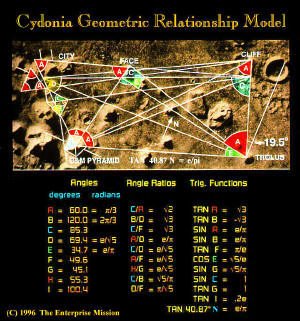
Image courtesy of the Richard C. Hoagland
SPSR researcher, Dr. Horace Crater (University of Tennessee Space Institute) has published a study on a series of "bright" mounds in the Cydonia region. Dr. Crater's research shows that the mound locations are distributed across the Cydonia area in a pattern based on the square root of two, and asserts that this distribution is not one that occurs randomly in nature. Such observations tend to bolster the artificiality hypothesis.
The "Face" and "city" at Cydonia would seem to satisfy two of our classes, those being possible surface structures and large scale effigies. Cydonia is also located just west of the "great yellow spot" of Mars, an area receptive to life due to the abundance of water. It was in the Meridiani area that Lowell sketched a large set of spokes radiating out from the wetland towards Cydonia and Acidalia Planitia.
As the Cydonia Mensae region has been scrutinized
(with seemingly religious zeal) for some time, rather than review the peculiarities
of the area at length (ground water, surface structures (pyramids), effigies
(the Face) and the "glass tunnel" anomalies-most notably McDaniel's
"coat hanger"with parallel striations- (our "tunnel ribs"-adjacent
to the dolphin effigy which may have once fronted a larger structure since
fallen into ruin), we can comfortably state to Lowell's betting friends that
the odds makers willing to gamble conclude that the Cydonia region carries
300 to 1 odds of proving our hypothesis correct.
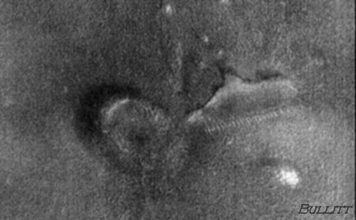
Cydonia-Dolphin effigy with tunnel ribs
Image Courtesy of Keith Laney
Is this the "effects of
local intelligence"?
We believe Lowell would say, "Mathematics? Most definitely!
Yes! Architecture! Certainly! Culturally significant anthropological artifacts!
Without a doubt!"
Data from the NASA and ESA probes may well answer that question. The Europeans have a palpably milder reaction towards theories of extraterrestrial life than do their American counterparts. Perhaps some revelations will come from this new set of eyes scrutinizing Mars.
"We find, in the first place, that the broad physical conditions of the planet are not antagonistic to some form of life; secondly, that there is an apparent dearth of water upon the planet's surface,and therefore, if beings of sufficient intelligence inhabited it, they would have to resort to irrigation to support life; "
-Percival Lowell
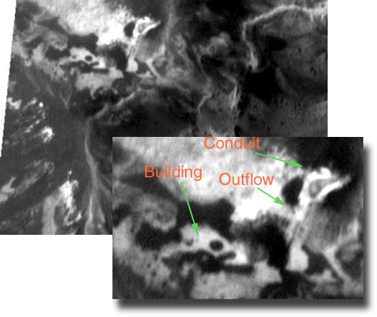
AB108405 - The "Port"
Image Courtesy of Mars Unearthed (Tripp McCann
)
Scaled pixel width: 4.59 meters
This apparent "geometric"
structure discovered by geologist T. J. McCann in image AB108405
and dubbed "The Port" appears
at least
to this author to be a building on the surface of Mars.
Just above the building is what appears to be a large outflow pipe for the purpose
of drainage. If not a clear indication of Lowell's proposed planetary irrigation
system it certainly resembles some type of building with drainage facilities.
The "Port" itself is of considerable size, measuring 243 meters by
160 meters. The circular opening in the roof is approximately 50 meters in diameter.
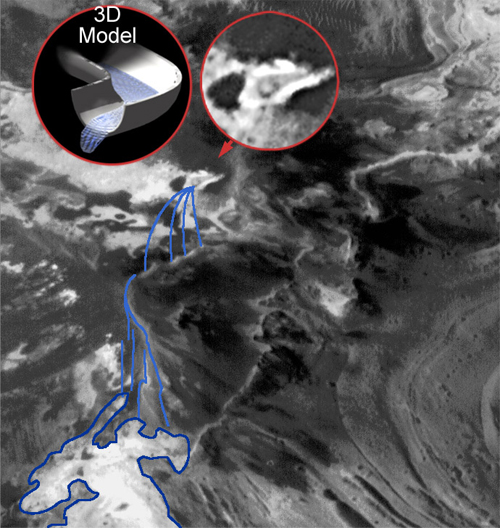
Image Courtesy of Mars Unearthed (Tripp McCann )
One image makes an anomaly. Finding similar
anomalies begins to show a pattern or reveal a "class" of objects
indicative of Lowell's mathematical sets with
finite details.
MOC image E12-00720,
was one of the 10 potential NASA 2003 Mars Explore Rover (MER) landing
sites. Although not selected for a mission, (instead NASA in its infinite wisdom
chose to explore the highly exciting, dust filled Gusev crater basin) this area
is home to other astounding and culturally significant anomalies in addition
to the structures shown here. The crop
below covers an area of approximately 1.5 kilometers by .9 kilometers.
The structure with the dark"openings is 65 meters across it's longest axis. The outflow pipe to the rear protrudes approximately 25 meters from the cliff face. The section of pipe spanning the divide near the center of the crop looks to be about 75-80 meters from the point it becomes visible to the opening in opposing cliff face. Other sections of plumbing are also visible as indicated.
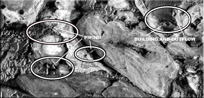
MOC Image E12-00720-Building and outflow
Scaled pixel width: 3.01 meters
Images courtesy of Eric C. Lausch
© 2002 Dangerzone Productions
Mars Researcher Eric C. Lausch
believes this to be a similar installation to McCann's Port, with outflow pipe
directly adjacent to the structure, analogous MOC image AB108405. Additional
piping can be seen in the general vicinity along with what are possibly some
additional structures and possibly heavy equipment in the area (directly below
the "W" in the word outflow one can discern a white cube- looking
for all the world like the large steel industrial buildings seen on Earth, along
with other interesting items at the limits of the image resolution). Just southeast
of the cube we see a large domelike structure with concentric rings around its
top complete with a sun angle consistent shadow.
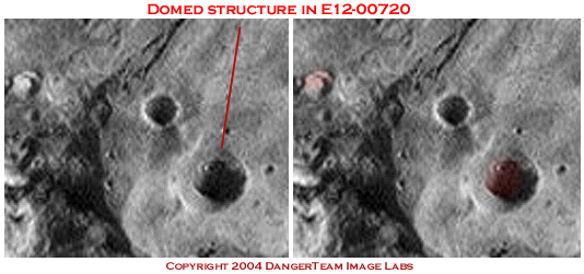
Domed structure in E12-00720
© 2004 Dangerzone productions
Comparison of structures from AB1-08405 and E12-00720
© 2002 Dangerzone productions
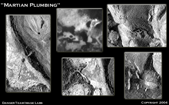
Image Courtesy of Danger Team Image
Labs
© 2004 Dangerzone Productions
Another interesting thing to note is the geographical proximity of these two installations. Both are located in the equatorial region only 170 km apart and almost on a straight line with each other, possibly indicating that these are part of some larger infrastructure of intelligent design just as Lowell had suggested. Both facilities lie almost directly where Lowell drew two of the largest diagonally crossing north-south canal sections and some large nodes. It then reasons that if there were intelligent beings present on Mars this would have been an excellent location for Marshaling water resources. Perhaps water flowed from an underground source through the outflow pipes to feed a local reservoir which supplied water for the area.
Danger Team and SPSR Member John Levassuer was (like a true academician) kind enough to invoke the Pythagoras and write this tutorial for quick and dirty Mars distance conversions. As many intelligent folks reading this piece do not perform this type of mathematical acrobatics on a regular basis we feel it appropriate to include it here as an illustration of the scientific demeanor that serious scientists who research the possibility of cultural artifacts on Mars adhere to in their analyses. And should you ever wish to perform this type of calculation in your own research it may prove a useful reference.
"The equator is zero degrees. From
this circle, lat angles are measured "north" and "south",
with 90N and 90S at the poles.
Longitude is measured from an arbitrarily located circle perpendicular to the
equator.
All longitude angles are usually measured
toward the west for simplicity.
Radian measure: Imagine a circular sector, part of a circle shaped like a piece
of pie.
The two straight sides that meet to form the angle are Mars' radii (meeting
at the centroid of the planet).
The radius of the planet is known, 3397 km.
The curved edge of our pie, the "crust", is the arc length. (It is
this length you are asking me to find, but at different angles.)
One radian (57.3 degrees) is the angle
created when the radius and arc length are equal.
So at one rad, or 57.3 degrees,there
is an arc length, or surface distance of 3397 km. So if 57.3
degrees corresponds to 3397 km, then one degree corresponds to about 60 km on
the surface of Mars.
(Of course the larger the planet, the
greater the corresponding surface distance at the same angle.)
But the distance you ask me to find is not perfectly vertical or horizontal,
so two distances must be found using lat and long. Since these
distances are perpendicular, the diagonal distance between the two points can
then be found by applying Pythagorous.
Calculations:
Difference in lat = 8.86 * 6.81 = 2.05, about 120 km
Difference in long = 77.61 * 75.45 = 2.16, about 120 km
Diagonal distance = square root sum of above squares, about 170 km
Your two points are approximately 170
km apart, the first point slightly more northeast than the second one.
Although a long commute, they're fairly close to each other."
-John Levassuer
Ok-now it starts getting interesting.
Going due south along in MOC Image E12-0072 from our "waterworks" building we find partially buried in the sands of Mars a number of titanic bas relief carvings. These appear to be enormous renderings of dolphins and whales (you knew there'd be dolphins), complete with dorsal fins, flippers and tails, all anatomically correct in size and placement. A clear indication of another of our "classes" of objects, falling under the category of culturally significant artifacts which includes effigies and intaglios.
The whale carving is over a kilometer in length and contains such detail that one can clearly make out the whale's eye. The smaller of the two dolphins measures a little over three hundred meters. There are also indications of other buried carvings but they are too submerged in the sand to clearly discern. Unlike the somewhat ambiguous eroded ruin of the Face at Cydonia these effigies contain clear anatomical detail that cannot be attributed to simple geological morphology or Aeolian forces (the wind).
MOC Image E12-0072
Scaled pixel width: 3.01 meters
Mega-Dolphins and Mega-Whales in Bas-Relief
Image courtesy of Keith Laney
However, we will now state unequivocally that there will be ardent proponents of the Cydonia Face's artificiality who will balk at the notion of other large scale effigies on Mars, especially one in the likeness of a cetacean. Face it (no pun intended), a civilization capable of constructing a monument like the Face wouldn't have stopped there. And it is no more highly unlikely to find an effigy of a dolphin or whale on Mars than it is to find the effigy of a human face. The ramifications of either such revelation are not lost on this author and are mostly responsible for present attitudes on this highly debatable issue.
As Percival Lowell had such a profound impact on the modern genre of science fiction it seems appropriate to steal a quote from from one of Lowell's intellectual progenies.
"Admiral, there be whales here!"
-James Doohan as Montgomery Scott, Star Trek IV, "The Voyage Home"
Ethical science can no longer summarily dismiss the statistically significant incidence of large intaglios, pictograms and effigies on the surface of Mars. As more of the Martian surface is imaged they crop up again and again, usually in conjunction with other surface anomalies such as our buildings or the glass tunnels. This pattern began with the Face and City at Cydonia in the mid 1970's has become ever more repetitive as we image the surface of Mars.
This area borders on a moderately dry area of Mars when compared to Meridiani. It is not unreasonable to assume that any system for managing water resources would require some type of surface installations resource management in outlying areas. A second relationship supports our second set. This image has shown us surface structures (our "port" type buildings replete with plumbing) which we hypothesize to be some type of water reclamation facility. The discovery of the Cetacean effigies in this area satisfies a third set by introducing yet another "class" of objects, landscape art or effigies to this area on Mars.
Going out on the proverbial limb, we theorize that there is a relationship between these unusual effigies, the surface structures (buildings) and the available groundwater resources in the area. Namely that these facilities and large scale works of art were both constructed by the sentient beings, who selected this area for Marshaling water resources.
Now we realize that this may be a tad too large a spoonful for some of our readers, but we beg your indulgence and ask that you read on.
Presently Lowell would have the odds of any theory encompassing three sets at 60 to 1 of proving the theory correct. Three outta four ain't bad. Alas the 300 to 1 odds are elusive this go-round as no visible glass tunnel anomalies are apparent in this image strip, robbing Lowell's bookie of a home run, like a talented outfielder leaping at the fence. However, this does not preclude the possibility that such tunnels are present below the surface.
However there are indications of
the glass tunnels in the equatorial region. Located east of our waterworks facilities
at longitude 15.65�W and latitude 3.97�N is MOC image M1104220. At 1.45 meters
per pixel resolution this is the highest resolution image found to date of the
glass tunnel anomalies. The "checkerboard" layout of the glass tunnels
would seem to indicate a system intelligent design. One can clearly see the
tunnel terminate at an opening in the terrain similar to the overflows at McCann's
"Port" and Lausch's "waterworks" facility.
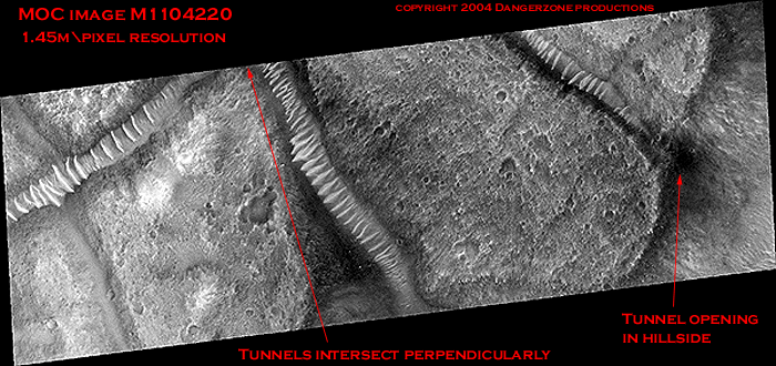
Image Courtesy of J. Danger
© 2004 Dangerzone Productions
"thirdly, that there turns out to be a network of markings covering the disk precisely counterparting what a system of irrigation would look like; "
-Percival Lowell
Details of the Martian Canal
system
Plate #1 from Lowell's 1894 Mars opposition studies
MOC Image M04-00291 (first discovered by Richard C. Hoagland in 2000) is what initially spurred interest in this phenomenon and the obligatory musings on Lowellian mythos. Further study has revealed this to be anything but an isolated image. The "glass tunnels" can be found in dozens of MOC images and are heavily concentrated in the Acidalia Planitia region west of Cydonia as well as being indicated in Oxia Palus, Chryse, Xanthe Terra and as far away as the equatorial regions.
In order to properly evaluate the significance
of MOC M0400291, one must look at the big picture. The capture below from MSSS
shows the narrow angle image strip that created such a ballyhoo in context of
its relative location in the Acidalia Planitia region, as shown in the wide
angle context image to the left. The small white polygon represents the narrow
angle image strip transposed onto the surrounding terrain.
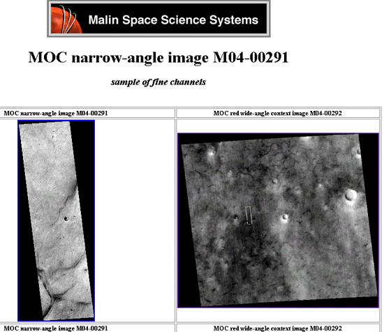
http://www.msss.com/moc_gallery/ab1_m04/images/M0400291.html
Image Courtesy Mike Malin
Percival Lowell would have been beside himself
to hear a representative of the Jet Propulsion Laboratory dismiss this unusual
image as sand dune when it so obviously plunges into an abyss. The Enterprise
Mission was correct in it's supposition that this image was evidence of something
extraordinary. This image from Acidalia Planitia may herald the most significant
findings on Mars to date. The image below represents the lower left hand corner
of the white polygon. To give things a sense of scale the section of tunnel
with the infamous "shiny spot" is about 1.75 km long and approximately
200 meters wide. Fine channels indeed!
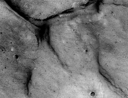
MOC Image m0040291a
http://ida.wr.usgs.gov/fullres/divided/m04002/m0400291a.jpg
Special Thanks to the Enterprise Mission
Dozens of images from the Acidalia Planitia area show evidence of the "glass tunnels" at the areas where these fine channels are located. They also appear in the Viking wide angle context images and are referred to as "cracks in the Acidalia region". A comparison of Viking's cracks to the fine channels shows these locations to have possibly been partially buried since the 1970's. Just to the northeast of the polygon there is a network of these "fine channels" resembling capillaries in the skin of Mars. Averaging 200 to 300 meters in diameter, this network stretches for hundreds of kilometers from Meridiani through the Chryse region and northwards to Acidalia Planitia and Cydonia. Narrow angle images from this area consistently reveal evidence of these tunnel structures in the channel locations.
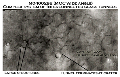
Acidalia tunnel system
Crop of MOC M0400292
Wide angle context Image for M0400291
© 2004 Dangerzone Productions
MSSS has utilized various nomenclature to to describe these areas
of high strangeness. The names ranges from cracks to fine channels, polygon
troughs to small Butte-filled circular features. Apparently they can't quite
get a handle on what these things represent. Perhaps they should simply refer
to them as "canali" in honor of Schiaparelli. This would be an apt
description and also keep them of the hook for artificiality.
Canal Map courtesy of Percival Lowell & Eric C. Lausch
© 2004 Dangerzone Productions
An interesting factoid is the high number of images or data points in this region. The total of wide angle, narrow angle and Themis images of Acidalia must total at least sixty images! To this author it would seem that whoever determines what MOC camera targets has a high degree of interest in Acidalia. Perhaps these tunnels are the driver for this data collection. Certainly, no comment is forthcoming from our space agency on their covert interest in this region.
Most of the two dozen or so glass tunnels
images we've seen to date have come from the Acidalia Planitia region. M15-01228
with it's domes and the "Oannes" effigy are here. We will be examining
about a half dozen other locations in Acidalia Planitia in later chapters of
this piece. In addition to the glass tunnels these images reveal large surface
structures which have an inherent relationship with unusual craters and large
scale effigies as we've noted in previous articles. Some of the images are quite
astounding.
Plot of MOC Narrow Angle Images showing
glass tunnels
Graphic Courtesy of Efrain Palermo
© 2004 Dangerzone Productions and Efrain Palermo
This graphic from Efrain Palermo
plots the MOC narrow angle images in Acidalia Planitia that show clear sections
of these glass tunnels. The grouping of the data points certainly does seem
to imply that these tunnels are part of a larger infrastructures of some sort.
One can already imagine Percival Lowell with a #2 pencil, or possibly one of
those new fountain pens (if for posterity) gleefully connecting the dots. Lowell's
observations were the progeny of four decades of solid research. One can only
wonder what fourty years of studying Mars with modern technology will reveal
to our children and grandchildren. Hopefully, they'll have the opportunity to
discover answers to such issues firsthand.
Possible network in Acidalia Planitia
© 2004 Dangerzone Productions
From the time that Secchi first used the term "canali" to Antonuadi's death in the mid-twentieth century, observers noted a steady change in the appearance of Mars through a telescope. Schiaparelli and others reported seeing the "canali" grow. Antonaudi reported seeing them fade away. Antonaudi observed the canals well into the twentieth century. Comparison to Schiaparelli indicate a drastic change in the appearance of Martian surface over a half a century. Schiaparelli's "canali" in the northern hemisphere have dried up and the vast southern Mares have shrunken and all but disappeared.
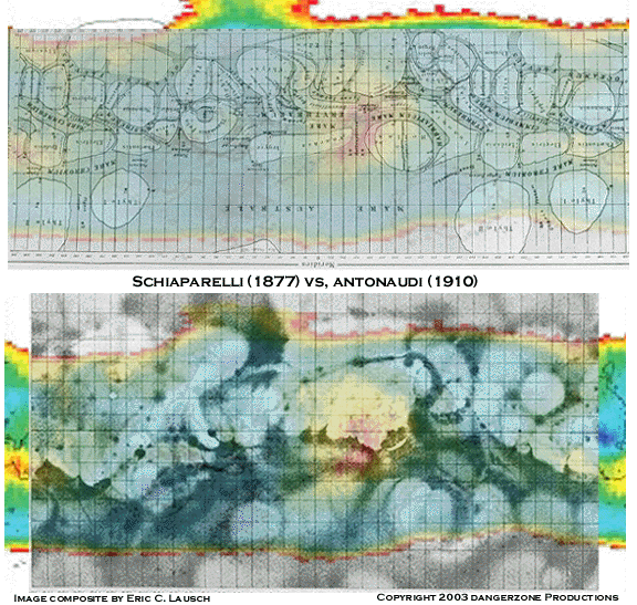
Schiaparelli's map of Mars (1877)Antonaudi's
map of Mars (1910) vs. water abundance
© 2003 Dangerzone Productions
Lowell's protégé'
Antonaudi reportedly captured images of the Martian Canali (circa 1910) by photographic
means. Unfortunately the materials were
delicate and do not survive today for our scrutiny. It
is interesting to note that Antonaudi's map of Mars, replete with canali was
still in use by the US Air force as it's
official map of Mars until the late 1950's. Upon perusal of various Mars renderings
produced from the 1850's to the 1920's one can see what appears to be steady,
continuous alteration of the Martian state of affairs as recorded by numerous
researchers via telescopic observations over a period of decades from Schiaparelli
to Antonaudi. After sketching the intimate details of these observed features
for many years, Antonaudi declared them an illusion after they were no longer
discernible.
What Lowell observed was the Mars
of Schiaparelli in transition to the Mars of Antonaudi. Antonaudi lived long
enough to see the Mars of his youth come to resemble the the Mars of Carl Sagan,
a sterile lifeless orb, pockmarked and desolate.
Antonaudi's Mars as compared to Hubble
images
Image credit: Tom Ruen, Eugene Antoniadi, Lowell Hess, Roy A. Gallant, HST,
NASA
http://antwrp.gsfc.nasa.gov/apod/ap031112.html
Face it. These fellows had adequate
equipment and were keen enough observers to know that something was happening
on Mars.
We're finding the same thing true of Mars today as new data shows just how untenable
the Mars science of the 1970's has become.
Modern day Mars researchers are keeping the spirit of Percival Lowell alive. Groundbreaking research on the Martian "Seeps" phenomenon, (first noted as possible water by Butcher and Hoagland) was conducted by Palermo and England in 2000. The seeps appear as long dark streaks running down the sides of steep, "dune covered hills", Over time and with subsequent multiple re-imaging of certain areas, these streaks are seen to dry up and disappear as new ones are formed in a different location nearby. Palermo and England theorized that liquid water could be the cause of these dark streaks and proceeded to map out and quantify statistically the occurrence of the "seeps". At the time (during the early years of Mars Global Surveyor) they received scant attention from the planetary science community as the idea of liquid water on Mars was still considered heresy according to 1970's science.
NASA predictably described theses
streaks as dust flows caused by the mass wasting of none other than the proverbial
Martian sand dune.
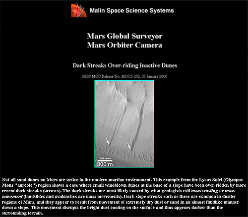
Image courtesy NASA/MSSS/JPL
Studiously plotting points on an epithermal neutron map, Palermo and England saw that the majority of the seeps fell on areas with an abundance of hydrogen, indicating a high probability of water. It seemed reasonable to conclude that their was a relationship between the seeps and local groundwater resources. There was however, the nagging question of why so many of these "seeps" fell on areas with low hydrogen counts, indicating a severe dearth of local water resources. This fact seemed to give some credence to the mass wasting theory proposed by MSSS.
Statistically, the seeps are distributed
bi-modally which tends to support the Mars Tidal Theory as postulated by Hoagland
and Bara. Hoagland theorizes that the large aquifers are the remnants of former
tidally locked oceans on Mars prior to the cataclysm that indelibly altered
the nature of Mars for all time. Their paper can be found at http://www.enterprisemission.com/tides.htm
.
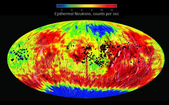
Seeps plotted on Epithermal Neutron map
Image courtesy Efrain Palermo and Jill England
Several subsequent "white papers" on the "seeps" have been published in peer reviewed journals by university researchers, most of which ignore or fail to cite the authors of the original "seeps" paper. Another shining example of the how far ahead of the curve Mars anomaly hunters are as compared to government funded researchers. It also serves to illustrate how viable research done by those outside of the planetary science community comprising NASA, JPL and MSSS is either ignored or summarily dismissed out of hand without a even cursory inspection for merit. Like Giovanni Schiaparelli and Percival Lowell, Jill England and Efrain Palermo were well ahead their time in their hypotheses regarding Mars.
Now, years after Palermo, England and Moore authored their paper, the planetary science community generally agrees that these "seeps" are indeed caused by some type of water action under the surface of Mars. There is however, no general consensus on what geological mechanism causes liquid water to burst forth from beneath the surface of the red planet. Common sense dictates that something under the surface is building up pressure until it reaches a threshold where a "seeps" event occurs.
Applying an equal dosage of common sense to MOC imaging data seems to imply a a complex network of underground conduits on Mars based on images showing a system of "glass tunnels" crossing the surface of Mars. If Lowell's planetary water system existed and was over time buried under a thick layer of Martian detritus there could be a possible connection between these glass tunnels and the Martian seeps. Lowell would have considered the proposal logical and suggested comparing the canals to the empirical data collected by Palermo and England. What started as an exercise in logic has yielded remarkable results.
Starting with a black and white
surface map of Mars as the background we have overlaid Lowell's canals with a map of
Palermo and England's seeps. Once again we brook no excuses for our lack of
formal training in cartography. I feel confident that the areas between 40 degrees
north and 40 degrees south are reasonably accurate (that's where all the action
is). For your reference please note that on Palermo's seeps map zero degrees
is at the right edge of the map. This would place Meridiani at the east and west
limits of the map rather than the center as seen earlier. Shown below are Lowell's
canals overlaid on the epithermal neutron map plotted with the seeps locations.
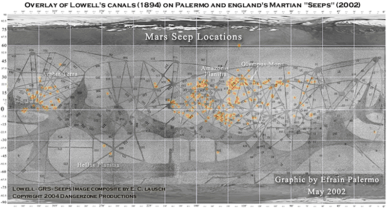
Overlay of Lowell plates 24A and 25B on
Palermo's "seeps" map
Image courtesy of Eric C. Lausch & Percival Lowell
Special thanks to Efrain Palermo, Jill England and Richard Hoagland
© 2004 Dangerzone Productions
The data points conform closely to Lowell's observations indicating a probable connection between the seeps locations and the canals Lowell sketched back in 1894. The overall pattern of the seeps seem to correspond directly to the sweep and geometry drawn by Lowell. Startlingly, many of the seeps score a direct bullseye on the nodes of Lowell's hub and spoke system, with many more treacherously close. A significantly larger number of seeps also fall directly on or are immediately adjacent the canals or spokes of Lowell's plates. Keep in mind that Lowell sketched his plates by hand while peering repeatedly through the eyepiece of a telescope while tracking Mars across the heavens.
Is this yet another happy coincidence in the search for Martian truths or an epiphany in the field of Mars research? My vote goes to epiphany.
We've proposed that the markings seen on Mars by early astronomers have a direct relationship to planetary water resources. Palermo and England theorize a similar situation with regards to the Martian Seeps. A full comparison of the two seems to verify both hypotheses as well as showing an apparent relationship between the seeps and Lowell's canals. This further supports the contention that what Lowell and Schiaparelli observed was a water related process that was discernible on the surface of Mars.
I imagine Lowell would feel gratified
to see us playing a game of Martian "connect the dots" on his canals
nearly a century after his demise. His opinion on the subject would prove fascinating.
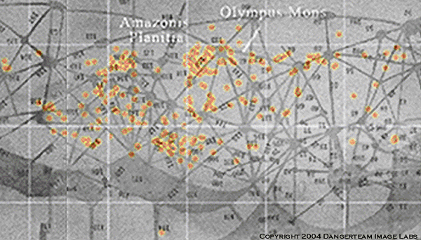
Image courtesy of Eric C. Lausch
Special thanks to Efrain Palermo and Jill England
© 2004 Dangerzone Productions
This analysis also sheds some light on the
occurrence of the seeps in areas of low hydrogen concentrations. Interestingly
enough, it is these areas where one finds the seeps in areas of limited local
groundwater (hydrogen) that the seeps seem to coincide to the drawings Lowell
made in 1894. The dots repeatedly fall near the hubs and spokes of Lowell's
canals in the more arid locations. If a system for directing
water supplies to remote locales in need of resources did exist and was subsequently
buried, the most likely place to find a leak would be at the tunnel locations,
similar to a water works employee looking for a leaking water main.
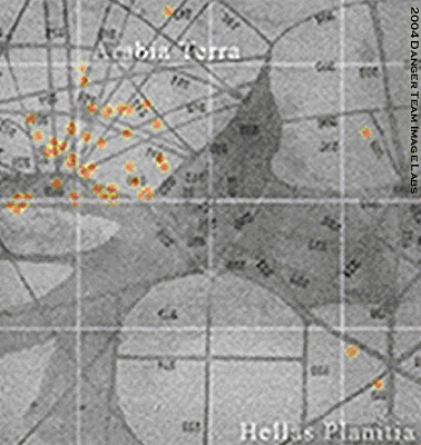
Image courtesy of Eric C. Lausch
Special thanks to Efrain Palermo and Jill England
© 2004 Dangerzone Productions
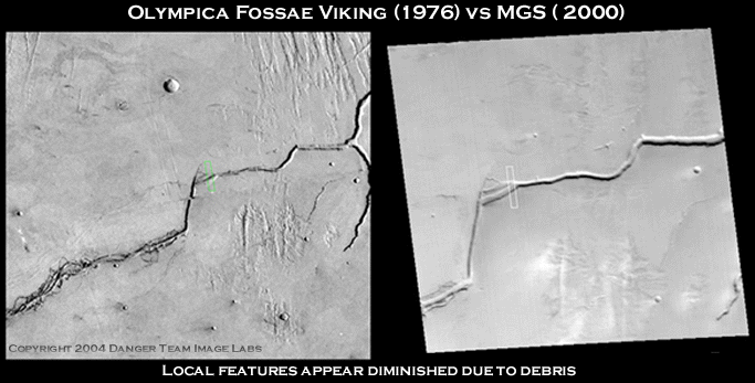
Viking context image for Olympica
Fossae circa 1976 - MOC wide angle context for
Olympica Fossae circa 2000
© 2004 Dangerzone Productions
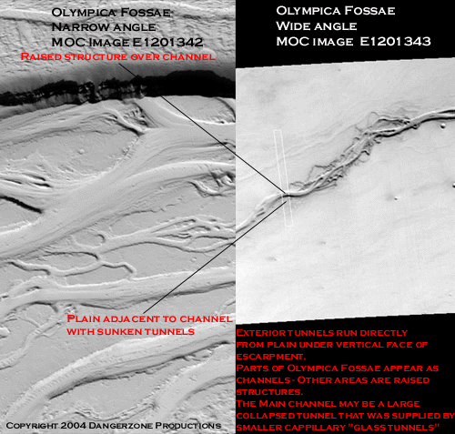
Above we have the Viking and MOC context images for the Olympica Fossae region. This enormous waterway already looks like one of Percy's canals winding its way across the surface of Mars. In the Viking image Olympica Fossae and its twisted periphery appear to be raised above the surrounding terrain when compared to the MOC wide angle image. To the upper right we can see one of Lowell's "canal hubs" with three spokes radiating from a central point as depicted in numerous times in Lowell's sketches. The lower segment of lower right branch appears to simply originate or terminate abruptly as if disappearing beneath the surface. Have you ever seen a river channel that just ended with no alluvial fan or large basin to empty into? An interesting phenomenon to say the least.
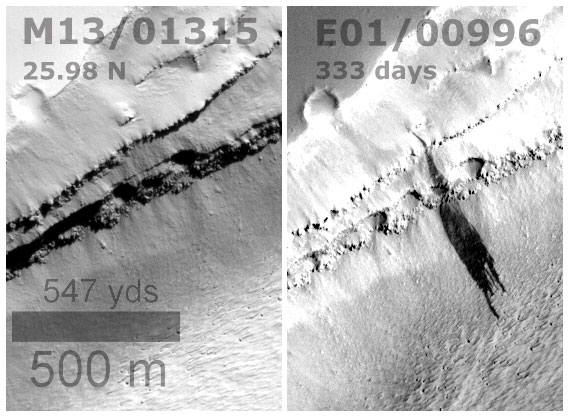
The small white polygon represents the area for MOC image strips M1301315 and E0100996 which are compared below. One wonders exactly what a higher resolution image of the "twisted" looking area to the lower left would reveal. The twisted area in the MOC wide angle image seems far less distinct than in the Viking image, one possibility being the area has slowly been covered with blowing sand or other fine particulates. A closer inspection is required for comparison of this twisted area to the fine channels in Acidalia Planitia. If our glass tunnels are some type capillary vessels for supplying a larger infrastructure fallen into disrepair we may find some corroborative evidence in these areas. Unfortunately once again MSSS chose to image the most mundane feature of those available in the region.
The experienced Mars anomaly hunter is most likely familiar with
circumstances where imaging parameters are just so and can cause a concave surface
feature to appear as if convex. After careful reconciliation of various views
it is apparent - although deceptive, that this narrow angle shot of Olympica
Fossae does indeed appear to be a trough based on the particular version of
the image analyzed by our imaging team.
Olympica Fossae
© 2004 Dangerzone Productions
Olympica Fossae did prove a boon
to Palermo and England's "seeps" research as it clearly shows a fresh
discharge of water from within the stratified layers adjacent to the canal.
We will discuss similar examples of this "stratification" or "terracing"
found adjacent to the glass tunnel anomalies later in this piece. It is possible
this waterway was once supplied via an underground sources related to our glass
tunnels. The overhanging terraces seem to have large voids in them as if they
opened into some larger underground chamber or system. The terraced area may
be part of a larger structure directly adjacent to the waterway which is buried
under debris.
Evidence of liquid water in Olympica Fossae
Image Courtesy of Efrain Palermo and Jill England
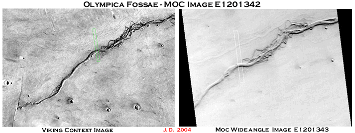
Taken just to the southwest of the Olympica
seep is MOC image E1201342. It reveals what one could only hypothesize about
the other images from Olympica Fossae. This being that the wild, twisted looking
areas adjacent to the main waterway are actually peripheral conduits of
the
larger Olympica Fossae tunnel. Olympica's capillaries criss cross Mars in all
directions- undulating out from the main branch like the tendrils of a fossilized
Martian crinoid on the bottom of a dried up Martian sea.
Viking context image for Olympica
Fossae circa 1976 - MOC wide angle context for
Olympica Fossae circa 2000
© 2004 Dangerzone Productions
Images from this area of Olympica Fossae are extremely difficult to evaluate as they seem to all suffer from an unusual affliction.
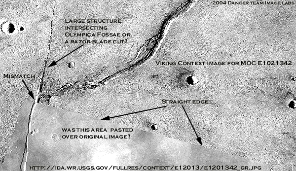
Now we do not say this lightly as the spectres of Mulder and Scully are peering over our shoulders and we do not wish to turn this into an episode of the X-Files. However, an unusual set of circumstances does surround MOC image E1201342 and it's predecessors. It's almost enough to convince one of a long standing, yet subtle conspiracy at NASA with regards to all things Mars. This image was taken by Viking almost thirty years ago. While inspecting the "twisted area" area adjacent to the main branch we noticed some surface areas in the image appear radically different from the bulk of the image. A linear feature looking like a large crack can be seen appearing from nowhere analogous to one of our glass tunnels appearing from below the Martian regolith. Olympica Fossae simply ends suddenly with no alluvial fan as if simply diving under the surface of Mars. This portion of the area does not appear in the MOC wide angle image.
However, upon examining the area in detail,
one must ask if there is something more unusual seen in this image than possible
intelligent artifacts on Mars. A large portion of the image appears masked off
and is bounded by straight edges running at right angles to each other. The
surface in this portion of the image appears markedly different from the rest
of the image.
"Cut and Paste"
Image Courtesy of Danger Team Image Labs
© 2004 Dangerzone Productions
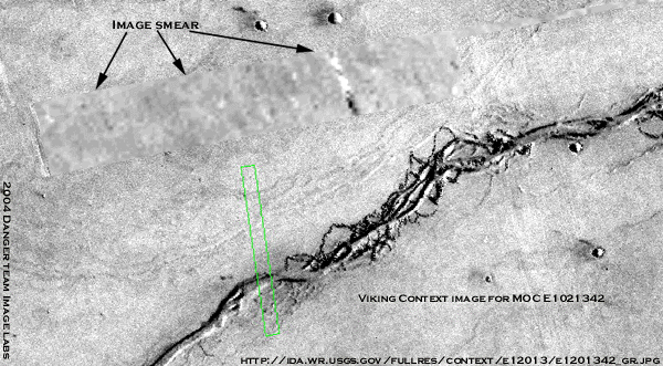
Another area in the Viking image has a large smear running across it. A long straight area of high albedo can be seen in the smeared region.
Agent Scully might well inform us that these effects may well
be caused due to 1970's technology, or some processing glitch in the reproduction
and archiving of the data. Mulder of course, would smell a cover-up. Whatever
it means - it is an interesting anecdote that this unusual area on Mars has
spots in this 30 year old Viking image are mysteriously distorted.
"Smear Tactics"
Image Courtesy of Danger Team Image Labs
© 2004 Dangerzone Productions
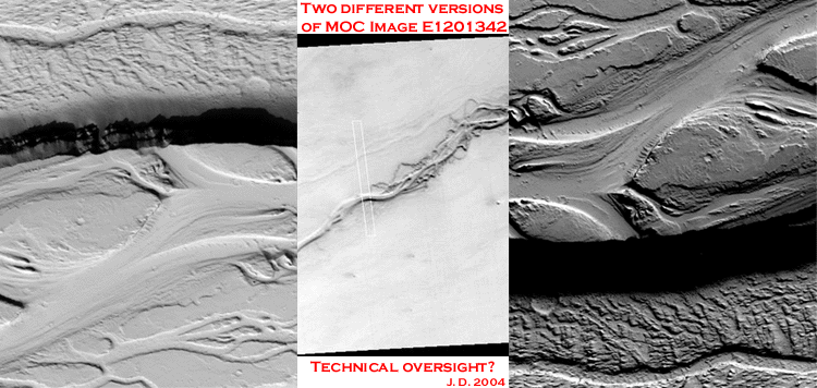
Then some thirty years later, along comes MOC image E1201342 represented by the green polygon in the Viking context image. Once again we see that MSSS managed to target the least interesting area in the vicinity. They have shots of both ends of the twisted area and none of the heavily populated midsection. Reflection along the length of Olympica Fossae in the Viking image would seem to indicate that this structure is raised above the surrounding flood plain.
MOC narrow angle images are archived in web repositories by Malin Space Science Systems and the United States Geographical Survey. Having looked at thousands of these narrow angle images on both the MSSS and USGS sites the postings for E1201342 seemed strangely matched.
As it turns out, there are two different versions of E1201342 available for viewing on the Internet. The version of MOC image E1201342 on the USGS site is mirrored both vertically and horizontally when compared to the version of MOC E1201342 on the MSSS site. As if this wasn't strange enough to begin with, while this was certainly this same image- it still looked different somehow. Shown below are both versions with the MOC wide angle image for context.
Based on the curvature of the dark edge
of Olympica Fossae as seen in the context image- the image on the left appears
to be correctly map projected. The dark swath clearly curves the wrong direction
in the right hand image.
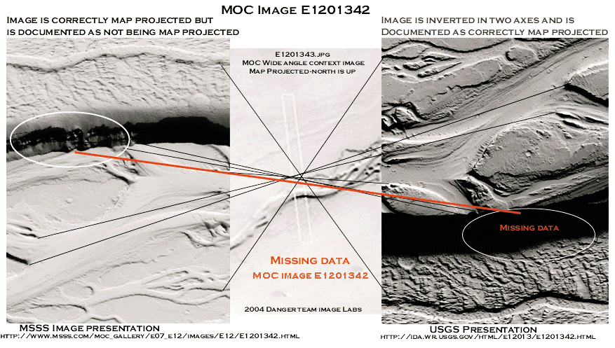
"Inversion"
Image Courtesy of J. Danger
© 2004 Dangerzone Productions
Aside from being inverted both the black and white color bands and two axes it also appears to incorrectly map projected - the overhanging lip of Olympica Fossae and the "sedimentary" looking layers that run along its outer wall are completely missing from the image on the USGS site! Somehow this image has been altered from its original condition. We can find no reasonable explanation for this situation other than human intervention.
Mulder concurs. Scully remains skeptical and points out that this may ultimately turn out to be the result of improperly contrasting the NASA IMQ file when creating images for the web. (Everyone knows that Mulder always turns out to be correct in such matters)
The obvious suspects would be the individuals who have access
to the data during the proprietary data period prior to public release and archiving.
This narrows the field down considerably as there is only one suspect available.
Malin Space Science Systems. However, if attempting some type of subterfuge
one would think they'd post identical images on both sites. It's almost as if
some areas are being leaked or altered in some way to quietly disseminate the
information and mark them for future study.
"The Mystery of the Missing Martian Data"
Image Courtesy of Danger Team Image Labs
© 2004 Dangerzone Productions
The offical NASA position is that this area was formed due to interaction between water mud and lava. This area either consists of water carved run-off channels or lava tubes. Or it might be the an archaeological remnant of a former high civilization on Mars. The images show huge flow channels that end abruptly at cliffs which appear to be at the head instead of the foot of a flow, so we have a place where a huge uplift, subduction, or later major flow event severed the older flow channels and destroyed any evidence of it's further course upstream. Even without a hint of artificialty it is a geologically fascinating area . At this point we must once again ask you to be the judge and form your own opinions on such issues.
So much for attributing this to a trick of light and shadow as far as interpreting whether it is a trough or a raised feature. This makes one wonder how many other Mars images have undergone a similar "processing enigma ". What are the chances that two images of the same area on Mars taken thirty years apart both having these mysterious data dropouts and processing glitches? I doubt that even Mr. Spock could calculate such astronomical odds.
Does this constitute proof of a clandestine effort to keep certain data from Mars from the American public? We can't say positively. It may only be a processing errors on the part of the overworked employees at MSSS and USGS. You be the judge.
Lose Something?
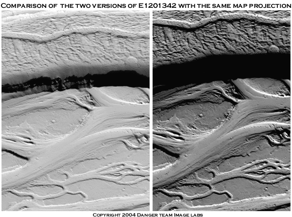
Comparison of the two versions of MOC Image E1021342
© 2004 Dangerzone Productions
One last avenue is available for analysis of the nature of Olympica Fossae. Mars Laser Altimeter data (MOLA) MGS uses a laser to create detailed topographical maps of the Martian surface. If this area is indeed a small, intact section of a structure raised above the surface it should be apparent after examining the MOLA data.
A common problem for researchers interested in MOLA elevation
data has been the not-so-simple manner in which the data must be retrieved and
tabulated after which graphs of some kind must be drawn for visual effectiveness.
Robert Smith, Information Technology Specialist at Northern Maine Community
College, has developed a web site in from which researchers can easily get this
data and color maps. Each line represents one orbit. The web site can be found
at http://24.198.97.12/mola/ .
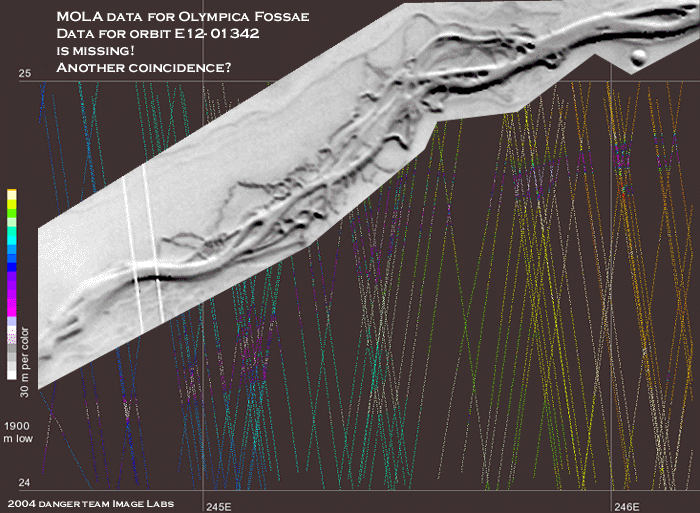
"The Mystery of the Missing Martian Data- Part 2"
Image Courtesy of Danger Team Image Labs
© 2004 Dangerzone Productions
While this foray into MOLA data has proven to be an excellent educational experience it does not help to resolve our inquiry concerning this area on Mars. The MOLA data for the area traversed by MGS orbit E12-01342 does not appear in the MOLA database. It should appear in the area directly below the white polygon. Is this simply another happy coincidence in a long series of coincidences that dates back over a thirty year period? You be the judge.
It is possible that long hours, tight budgets and over worked
government employees are to blame for these discrepancies. However, when combined
with the additional coincidence of the suspicious tomfoolery found in the Viking
and MGS images, one does need to stop and seriously consider the possibility
that another more conspiratorial explanation for this situation may be far more
credible than simple human error or custodial negligence. Someone desired to
obscure these areas from public viewing. As MSSS was not in even existence during
the days of Viking they could not have been responsible for the Viking image
and its peculiarities, so if there is an effort to alter certain data before
it reaches the public then it has been orchestrated for many years by the highest
levels of NASA bureaucracy.
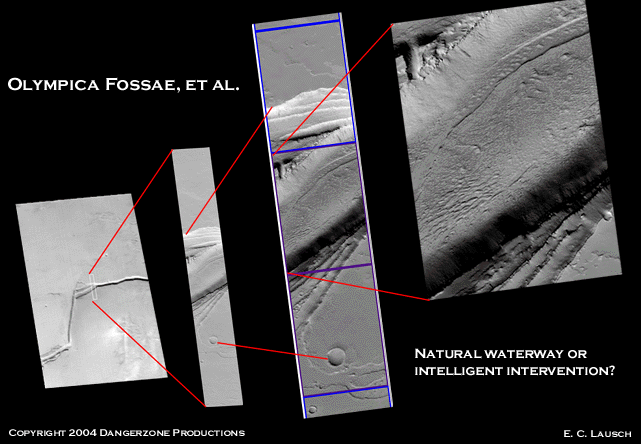
MOC Image e1201342 - Correct Map Projection
Image Courtesy of J. Danger
© 2004 Dangerzone Productions
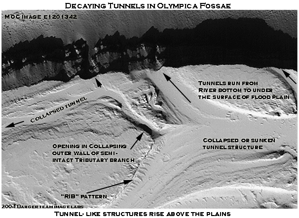
The correctly map projected seems to confirm what the was evident
in the Viking image. That parts of the twisted areas of Olympica Fossae are
raised structures above the floodplain. Other sections have collapsed and appear
as troughs. The tunnels can be clearly seen disappearing into what appears to
be a vertical escarpment rising above this section of Olympica Fossae. An immense
structure worthy of the title of "canal". Our tunnel "rib"
pattern can be seen running along one branch. Just above the ribs there is a
large hole where the sidewall of a smaller tributary tunnel appears to have
collapsed.
Raised Tunnels in Olympica Fossae
Image Courtesy of Danger Team Image Labs
© 2004 Dangerzone Productions
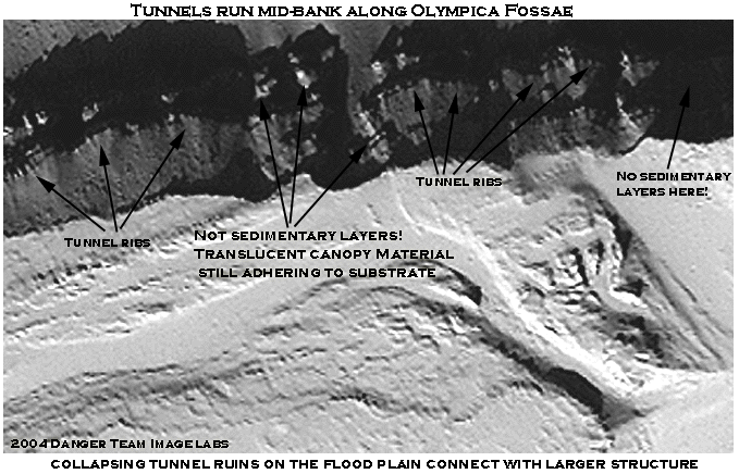
A close inspection of the layers running along the ridge indicates
that these are not sedimentary strata. There are continuous vertical areas of
light and dark that would not be found in sedimentary strata as it would run
unbroken horizontally. This appears to be the cover material for the tunnel
walls which is beginning to flake off in large patches. Fractured shards still
cling in spots to the parent material of the tunnel wall. About midway up the
wall one can see the telltale banding which appears to be the sidewall of one
of our glass tunnels running along the ridge horizontally.
"Tunnels at Mid-Ridge"
Image Courtesy of Danger Team Image Labs
© 2004 Dangerzone Productions
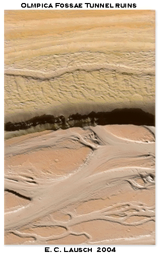
"Tunnel Ruins at Olympica Fossae"
© 2004 Dangerzone Productions
If an intelligently designed planetary infrastructure was present on Mars and subsequently covered with debris as a result of some cataclysm or planetary scale volcanic event, then large portions of the system may well be intact underneath the thick layer of dust that appears to cover most everything we see in images from Mars.
In this scenario these steep inclines
where the "seeps" appear could actually be our "glass tunnels"
or some other yet unknown part of this infrastructure buried like Pompeii under
layers of debris, slowly seeping water due to age and disrepair or possibly
deliberately shunting liquid out in order to maintain some internal balance
required for overall systemic health. The seeps may simply be the result of
normal operation for Lowell's canal network. The possibilities range from waste
water disposal to pressure regulation. Another suggestion for the seeps is leaking
water at expansion joints in the tunnel sections, which some of which sublimates
away and some of which freezes in exposed areas to form the distinctive white
"rib pattern" around the expansion joints.
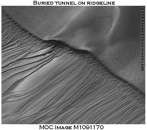
Buried tunnel ridge
Copyright 2004 Dangerzone Productions
It follows then, that either of
these explanations for the seeps necessitates that large sections of Lowell's
network are still intact and bearing water beneath the sands of Mars. If this
is the case, one must consider what other possibilities may lie below the surface
of Mars. An intelligently designed network such as Lowell proposed would necessarily
be accompanied by the additional peripheral infrastructure that it was built
to support. The obvious candidate would be buried cities on Mars - but that
is a subject best addressed at a later date when ground penetrating radar (GPR)
data is available.
.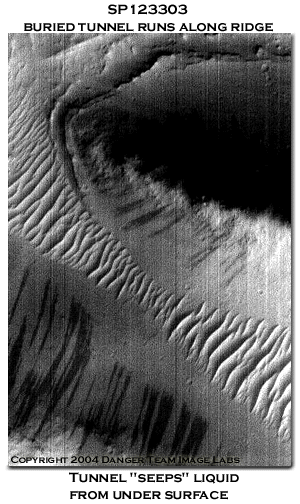
Buried tunnel seeps from both sides
© 2004 Dangerzone Productions
Above and below are crops from MOC image
SP 123303. Both show the distinctive ripple pattern of the support ribs seen
in the glass tunnels images. Indeed, trains of these riblike ripples can be
seen hundreds of images and have been attributed to Martian dune trains. Some
of these may well be dune trains. It is possible that some of these "ripples"
are the protruding ribs of the tunnel canopy that have been silted over by fine
particulates. Our Martian seeps can be seen leaking from the sides of the ridges
where these ripples are found. To our readers, we ask that you become familiar
with this pattern as you will see many iterations of it as we analyze images
strips containing the glass tunnel anomalies.
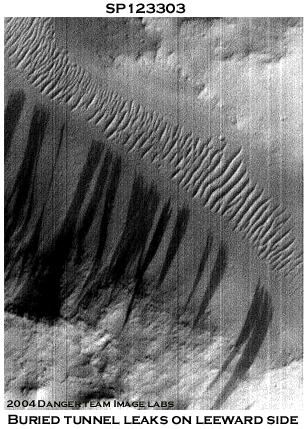
Buried tunnel seeps on leeward side
© 2004 Dangerzone Productions
Lowell would have immediately recognized these patterns as a roadmap to the buried infrastructure beneath the Martian regolith. The glass tunnels, once partially above ground, have been completely buried on the windward sides by layers of fine particulates. After years of silting over, the tubes eventually begin to resemble a dune covered ridge, with the tunnels leeward side becoming a steep drop off. Only the telltale pattern of the translucent canopy's rib-like supports is still visible as the dunes we see running along the ridge line.
A comparison of the tunnel support structures is shown below. At the tunnel junction two of three tunnels are still fully exposed to the surface. The branch entering from the right is almost completely buried. A comparison of the protruding ribs in E1601727 to the seeping ridge of SP123303 shows a striking similarity between theses formations. This is a pattern we see repeated again and again on the surface of Mars. The areas where the seeps are found are rife with long stretches of the "rib-like" dune trains. Our glass tunnels are found in locations of high local ground water as are the seeps. It follows that there may be a relationship between these anomalies.
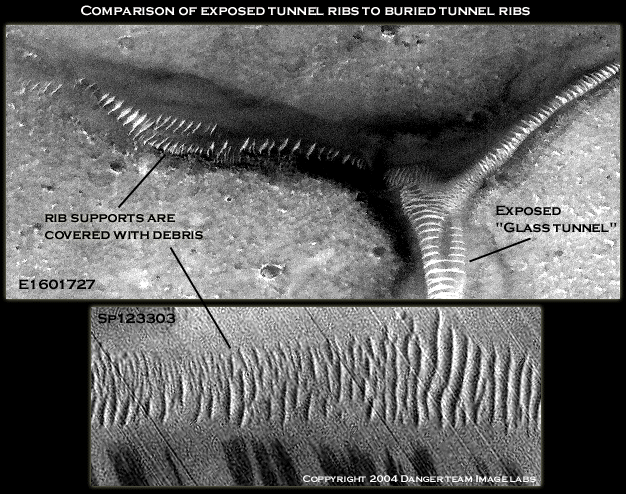
Comparison of exposed and buried tunnel
"rib" supports
© 2004 Dangerzone Productions
A team of Canadian scientists
recently estimated that Martian sand dunes can reach heights of 280 feet as
a result of Mars lower gravity. Certainly most terrestrial edifices would be
overwhelmed by dunes of such immense scale. Common sense says the same probably
holds true for Mars. Our partially buried whale and dolphin glyphs are a prime
example of how such large structures can be consumed by the Martian sandstorms.
The ESA MarsIS radar package may well hold the key to determining if any structures
are buried beneath the shifting sands of Mars.
From a civil engineering standpoint
one must consider how the water would be distributed from point "A"
to point "B". A comparison of Lowell's canals to a topographical elevation
map created with Mars Orbiter Laser Altimeter (MOLA) is shown below. The green
areas are at sea level, yellow are highlands and red are hills and mountain.
The blue end of the spectrum denotes low lying areas with violet representing
valleys and basins.
MOLA elevation data courtesy
of NASA / JPL / MSSS
© 2004 Dangerzone Productions
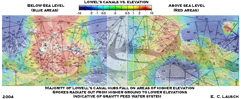
The major hubs of Lowell's system
(the origin points where the spokes radiate out from) fall exclusively at
areas
that are at higher elevations than sea level and branch out to areas of lower
elevation. This makes sense from a systemic perspective as it indicates a
gravity
feed water system similar to those seen in many metropolitan areas. Seattle,
Washington is an excellent example of this type of water distribution system.
Snowpak forms in the Cascade range during the winter months. During the spring
thaw the runoff is captured in reservoirs high above the city of Seattle,
which
is situated at sea level. The water runs downhill to the city, where the force
of gravity supplies water pressure to the local mains. Once again, the evidence
supports an intelligently designed infrastructure for water management and
leads
us to believe that Lowell and Schiaparelli documented an actual visible process
on the surface of our sister world.
Mars differs from Earth in that it has no magnetic field per se. Earth's magnetic field provides essential protection from cosmic radiation, allowing life as we know it to flourish. However, there are large swaths of Mars where the local magnetic field is many times the strength of the Earth's (in both polarities). Possibly, human astronauts could traverse these areas of Mars with little worry about radiation as the localized fields would offer protection. Currently, no generally accepted theory exists as to what causes these spikes in local magnetic field density.
Plotting these areas of high magnetic
field density against GRS water data once again reveals an intrinsic relationship
with water. Like Lowell's canals and Palermo's seeps, these "lakes"
of magnetism are clustered around areas of high water resources. However, as
in the case of the seeps, there are isolated areas of magnetism in extremely
dry areas.
Mars Water Vs Local Magnetism
source:
http://www.lpi.usra.edu/science/treiman/greatdesert/workshop/Marsmaps1/
© 2004 Dangerzone Productions
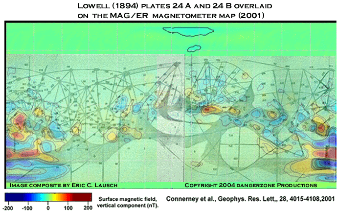
As a caveat to this we offer Lowell's
canals overlaid the MGS MAG\ER magnetometer map. This composite offers an even
more compelling scenario than than a comparison to of Lowell to GRS hydrogen
data did. The areas of highest magnetism coincide neatly with the major hubs
of Lowell's canal system. The islands of magnetism in the dry areas are invariably
intersected with one or more "canali" as was the case with the seeps
in these locations.
Canal image courtesy of Percival
Lowell
© 2004 Dangerzone Productions
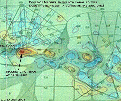
Once again Lowell's canals seem to cling inexorably to the data points generated. The areas high local magnetic field densities seem to be bounded in by Lowell's canals. Some of the highest densities fall directly on the larger "hubs" of Lowell's network. The blue lakes of moderate magnetism girdle the canals like a Martian golf course with a Lowellian cart path.
Lowell's canals would seem aesthetically
linked to all of the Martian planetary processes. This fact, if nothing else,
tends to support the hypothesis that what early astronomers observed on Mars
was an actual process related to the very same planetary data our probes are
acquiring today. Surely it cannot be ascribed as pure coincidence that men like
Schiaparelli and Lowell sketched something that so closely mirrors numerous
modern datasets. It is possible and indeed likely, that these interrelated phenomena
all spring from a central well or causal link.
Lowell's Canals overlaid on areas
of high magnetic field density
© 2004 Dangerzone Productions
A number of fledging theories attempt to explain the magnetic anomalies. One theory suggests the fields are caused by magnetized crustal remnants left behind by the dying Martian dynamo that once powered Olympus Mons. No obvious connection to water there. Another postulates the cause to be magnetized layers of sedimentary material deposited by ancient ocean, giving a nod to Mars watery past.
None of these hypotheses address the magnetic anomalies apparent geographical distribution around areas with large concentrations of hydrogen. After reviewing multiple scenarios it seems that only one theory, that of intelligent intervention, can reasonably account for the inherent relationships between Lowell, our seeps, GRS hydrogen counts and the powerful magnetic fields. An intelligently designed infrastructure for Marshaling water resources which was subsequently inundated by Martian debris. It fits together better than John Carter's Mars.
Realizing that most folks have infrequent contact with magnetometer equipment in their daily routine perhaps some explanation is required for those of you who don't follow how magnetometer readings fit into this scenario. This explanation from the Maine Department of Conservation Teacher activities sheet #38 should offer some insight into magnetometer theory and its repercussions in the field of archaeology, or in this case, exo-archaeology. Feel free to substitute "Mars" for "Earth" and be forewarned that the MAG\ER instrument on the MGS does not utilize kerosene, as it is one of those "other" types of magnetometers referred to.
"BACKGROUND : The magnetometer is an instrument which measures the strength of the earth's magnetic field. This magnetic field is not uniform, but varies from place to place around the earth.
In one type of magnetometer, the proton magnetometer, an electric current is applied to a coil around a bottle containing a fluid such as kerosene. The electric field produced in this coil realigns the protons in the fluid. When the electric current is shut off, the spinning protons again realign to line up with the earth's magnetic field. In so doing, they generate a signal which is proportional to the strength of the immediate (local) magnetic field. This signal is amplified electronically and measured by the use of counter circuits. The reading then appears on the digital display of the instrument.
Once the magnetometer is adjusted for the area where it is to be used, it becomes an instrument for detecting many buried features which affect local magnetism. Because compaction concentrates magnetic particles in the soil, the magnetometer will indicate ancient roads and dwelling places. Since heating magnetizes clay particles used in brick making, walls of long buried buildings can be located. Since rocks are more compact than soil, making them more magnetic, the magnetometer can detect the walls of long forgotten cities now buried. Certain ore deposits are readily found with this instrument. It is the basis of the military mine detector. The magnetometer is currently being used to detect buried drums which may contain hazardous waste materials. Because these drums are made of steel, they have magnetic properties to which the magnetometer is sensitive. Magnetometers measure magnetism in units called gammas. In Maine, the earth's magnetic field is normally 55,000 gammas. When this number is discounted, any change in magnetometer readings is due to local effects, that is, objects or formations which have magnetic characteristics."
Percival Lowell would have immediately grasped the implications of the magnetometer data. It shows evidence of buried structures and high tech construction materials that can only be the product of civilization. This said, it is reasonable to assume that civilization would thrive in areas of plentiful water resources. Lowell would've offered this up as further evidence in support of his intelligent design theories. The light blue areas of magnetism that shroud the canals could thus be explained as the electromagnetic signature of the construction materials utilized by the builders. Perhaps the pools of dark red magnetism are further evidence of large underground aquifers and the infrastructure used to manage their resources. A virtual map to a system of underground lakes linked by our glass tunnels and larger "canali" on the surface.
Lowell would be betting at 60 to 1 odds right now with the seeps, groundwater and the canals all seemingly related. Adding a fourth set, the crustal magnetism data might make a man feel lucky enough to bet the longshot, wagering everything on artificial constructs in the sixth race.
The magnetometer however, is not the instrument of choice for exo-archaeologists. This honor falls to ground penetrating radar, a process which has been used successfully by terrestrial archaeologists to discover ancient cities here on Earth. The ESA's MarsIS instrument has the ability to see far below the surface of Mars. Three dimensional graphics similar to CAD solid models can be rendered from the radar data. If there are glass tunnels, buried cities and underground oceans on Mars - MarsIS will find them. The real trick becomes data accessibility. As we have compared so many data types to Lowell's canals at this point, we feel uniquely postured to pursue the analysis of ground penetrating radar data as it relates to Lowell's canals and other surface anomalies.
We would be remiss when discussing the Martian magnetic field anomalies if we did not note one other possibility for the locally high field densities: Electromagnetic soup. If the indigenous Martian civilization that built the glass tunnels was eventually driven below ground due to extreme environmental changes the huge swings in local magnetic fields could be the byproduct of machinery and power sources beneath the surface. The implications of such thinking are sobering as our current data is still insufficient to totally rule out such a possibility.
In every comparison of contemporary Mars data to Lowell"s plates there are correlations between the intelligent design theory and and the geophysical data. There are definite relationships between water resources and topography that fit comfortably into that mindset. The strange elctromagnetic fields and geographic proximity to the "Seeps" also work nicely into the designed "canal" hypothesis.
But enough on these issues as the critical ESA \ MarsIS data will several years in coming and the Mars Reconnaissance Orbiter is still in the build stage for a 2005 launch window. Suffice to say that if there is a closed system for water circulation and buried cities under the surface of the red planet, then the Martian "seeps" and highly localized magnetic fields may well be a byproduct of the planetary system infrastructure associated with the glass tunnel anomalies. Our knowledge of Mars is not yet substantial enough to discount the probability that such things are possible. Access to ground penetrating radar capabilities will greatly enhance our ability to investigate such scenarios.
Images of our "glass tunnels" and the associated tunnel "ribs" or supports have been the subject of copious speculation on the nature of this phenomenon. The obvious Lowellian comparison to these tunnels is unavoidable. If as Lowell believed, there was once a planetary wide infrastructure for water management it then follows that various crumbling archaeological remnants of this system would inevitably be imaged on the surface. As we will be examining several apparently intact sections of the tunnel system later in this piece, it seems prudent to investigate the possibility that we have imaged some other ruined sections of this infrastructure aside from the ruins of Olympica Fossae.
A crop from MOC image E0100376 was the
Mars pic of the day for Dec. 18, 2003. The context image shows another area
of fine
channels or cracks that just seem to appear in the surface. Annoyingly enough,
a large swath of this image strip has a data dropout and appears
black. The
blacked out area is at the point where this "crack" suddenly appears,
making analysis of the channels origin point impossible. One wonders what
impossibility
was found in the blacked out area and who gave the order to remove it.
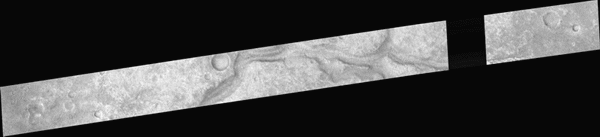
Missing Data in MOC Image E0100376
Image courtesy NASA / JPL / MSSS
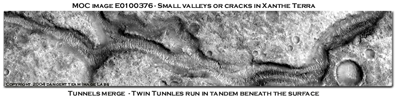
Small valleys or cracks in Xanthe Terra
© 2004 Dangerzone Productions
Even more markedly unnatural is another
phenomenon of this most phenomenal system, of which almost every one has heard,
and which almost nobody has seen, --the double canals. To see them, however,
all that is needed is a sufficiently steady air, a sufficiently attentive observer,
and the suitable season of the Martian year. When these conditions are observed,
the sight may be seen without difficulty, and is every way as strange as Schiaparelli,
who first saw it, has described it. So far as the observer is concerned, what
occurs is this: Upon apart of the disk where up to that time a single canal
has been visible, of a sudden, some night, in place of the single canals he
perceives twin canals,--as like, indeed, as twins, if not more so, similar both
in character and in inclination, running side by side the whole length of the
original canal, usually for upwards of a thousand miles, of the same size throughout,
and absolutely parallel to each other. The pair may best be likened to the twin
rails of a railroad track. The regularity of the thing is startling.
-Percival Lowell
Shown here is a large channel with two junctions.
Covered with dust, our tunnel ribs can be seen running the entire length of
wash. One tunnel enters into the larger channel at the junction point. From
here on one can apparently see two of our glass tunnels running side by side
under the debris filled wash. A closer inspection of the twin tunnel area shows
a severe deformation of our normally well ordered tunnel ribs with large swaths
of fractured material clinging to them. Large sections of intact material can
still be seen raised above the general level of the area. It is possible that
debris has filled in the collapsed areas creating a dark section that causes
the appearance of two tunnels where there was actually one large, under roof
structure originally. Possibly some structure remains intact below today.
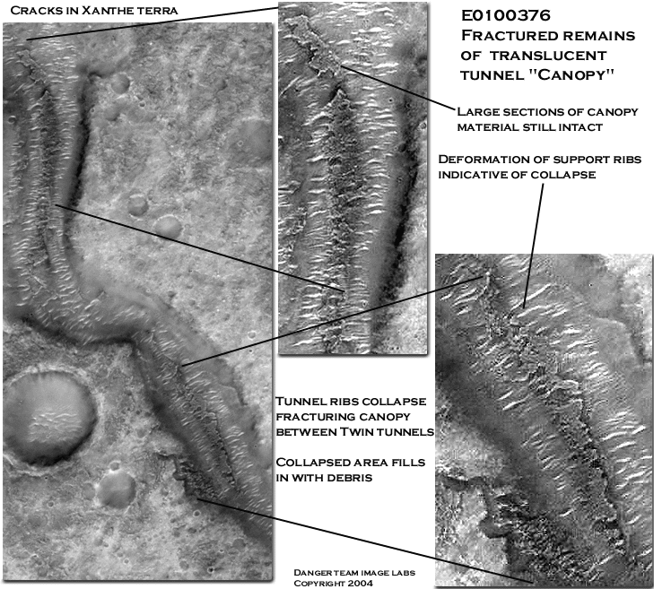
Buried tunnel with fractured remains of translucent tunnel canopy material
© 2004 Dangerzone Productions
The following thumbnail was featured as
Nasa's Mars picture of the day on November 22, 2003.
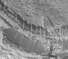
Rocks Exposed on Slope in Aram Chaos
MGS MOC Release No. MOC2-550, 20 November 2003
http://www.msss.com/Mars_images/moc/2003/11/20/index.html
A description of the image from the NASA site:
"This spectacular vista of sedimentary rocks outcropping on a slope in Aram Chaos was acquired by the Mars Global Surveyor (MGS) Mars Orbiter Camera (MOC) on 14 November 2003. Dark piles of coarse talus have come down the slopes as these materials continue to erode over time. Note that there are no small meteor impact craters in this image, indicating that erosion of these outcrops has been recent, if not ongoing. This area is located near lon 2.8�S, lat 20.5�W. The 200 meter scale bar is about 656 feet across. Sunlight illuminates the scene from the lower right. "
This image is located very near where Lowell sketched a large canal and may show a ruined section of one of our "glass tunnels". Upon my initial amazement at seeing this thumbnail we contacted Malin Space Science Systems for additional information on this image, requesting additional information about it and inquiring as to whether or not this small image has been cropped from a larger image strip which we could analyze. Weeks have passed and no response has been forthcoming from MSSS. So much for assisting the tax paying public in accessing the Mars data it's tax revenue supports. I did not receive so much as a, "we'll check on it and get back to you"! As Dr. Malins organization seem to have an unofficial policy of ignoring requests from the public with regards to Mars data, we will have to form our own conclusions about what this image reveals.
Our research on these edifices has shown
there to be three main categories of structural components associated with this
phenomena. The semi-translucent "glass like" material at the top of
the structure as seen in MOC Image m0040291a (with it's "shiny spot"),
the opaque material of the structural supports or "tunnel ribs" (creating
the sharp contrast in albedo that make these tubes so recognizable) and a sedimentary
looking material analogous to concrete in it's appearance as seen in the immense
rooflike structure in MOC images M15-01228 (directly adjacent to the "Oannes"
effigy). At the junctions of the larger tunnels the ribs become tightly spaced
to form what appears to be a solid mass, similar in albedo and appearance to
the "roof " in M15-01228. It follows then that the tunnel "ribs"
may be made of similar material as are the canopies and base of the tunnels.

Collapsed tunnel in Aram Chaos
MGS MOC release no. MOC2-550
© 2003 Dangerzone Productions
In the first illustration we see this structure, totally unique in regards to the surrounding terrain. Archlike in nature, it curves both laterally and vertically precisely mirroring the curvature of the escarpment behind it. A dark layer of stratified rock can be seen running behind the tube wall accentuating the top edge of the structure. Along the smooth curving base of this artifact a crack can be seen separating it from the adjacent terrain peeling part of the structure up with it similar to the behavior of broken Portland cement structure that have internal structural supports of steel rebar.
This "outcropping" measures over
1200 meters in length and towers 300 meters above the plain! The escarpment
to the rear is approximately 500 meters in height.
If this is a remnant of Lowell's canals then the volume of water it had the
capacity to transport would be tremendous!
As the "outcropping" rises a transition can be seen from the smooth base to the what appears to be the formation of the now familiar "rib like" structures associated with the tunnels. On the face of the escarpment a neatly spaced series of semicircular depressions is evident. This formation seems to align directly with the vestigial "ribs" that we see beginning to form. This is precisely what one would expect was a remnant of one of our "glass tunnels". Picture it's supporting ribs arcing up and across the glasslike material and then around to the other side to mate with the solid base diametrically opposed to our "outcropping".
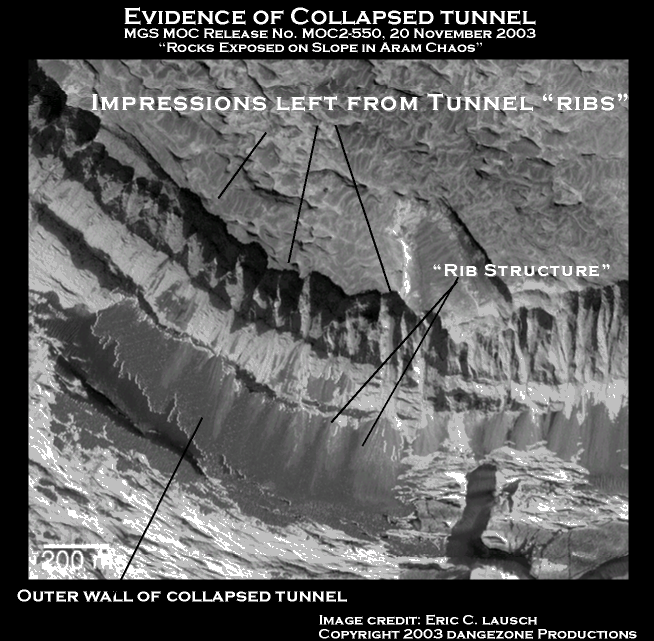
Collapsed tunnel in Aram Chaos
MGS MOC release no. MOC2-550
© 2003 Dangerzone Productions
Another interesting aspect of this image is a preponderance of high albedo or "shiny material". Pieces of it can be seen literally sticking to the cliff face on top of the stratified layers. What appear to be stress cracks or fractures can be seen in what looks to have once been a solid sheetlike mass of this material, looking for all of Mars like a broken windowpane of shattered glass. In the lower right hand corner we see a curious "L" shaped structure which seemingly connects out of the frame to the adjacent material the same dark color just to the right of the "L. This material of darker hue seems to be of a different composition, unique from everything else we see in the image. It may well represent some type of structural support analogous to the structural steel used in our own engineering efforts.
Between theses two "members" we
see what appears to have once been a continuous sheet of glasslike material
that has been smashed but did not shatter, similar to reinforced safety glass
in an automobile windshield. Just above the top of the "L" we see
some long linear fractures running the length of the debris, a possible indication
of some type of reinforcing cable analogous to rebar in the glass to help evenly
distribute loading across its surface.
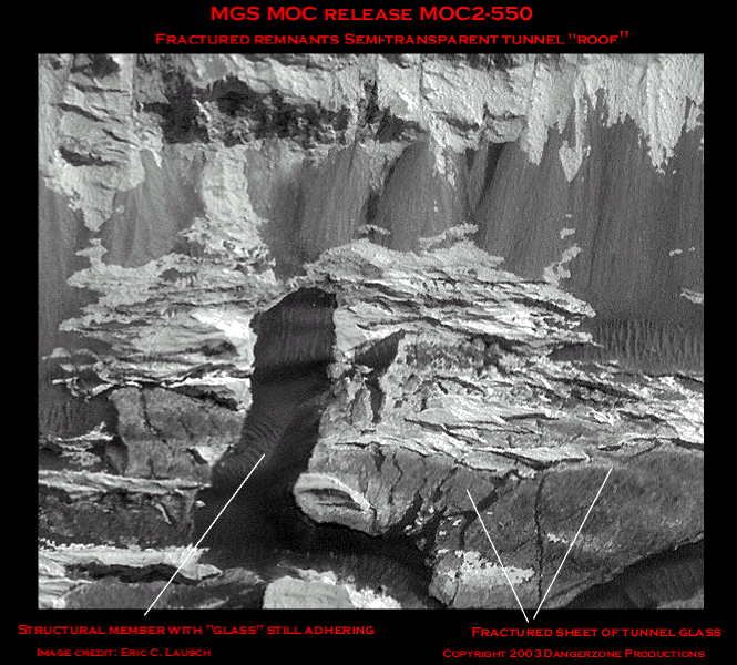
Fractured sheet of translucent
canopy material
MGS MOC release no. MOC2-550
© 2003 Dangerzone Productions
A comparison of the "roof" structure
at Grand Central ( M15-01228) from the Acidalia Planitia region and our "outcropping"
is shown below. The general arc and curve of the "outcropping" is
definitely similar in configuration to the base of the lighter colored "roof"
area just right of the "Oannes" effigy. I'd wager that a decent material
analysis would show these to made of the same material. Hopefully, NASA or the
ESA will investigate this issue in greater detail.
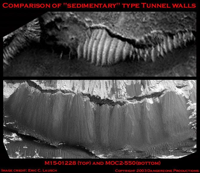
Comparison of tunnel walls
© 2003 Dangerzone Productions
"and, lastly, that there is a set of spots placed where we should expect to find the lands thus artificially fertilized, and behaving as such constructed oases should."
-Percival Lowell
What did trained, meticulous observers and scribes such as Green, Lockyear, Schiaparelli and Lowell see and record on the surface of Mars in mid to late 19th century? Martian vegetation and it's relationship to ground water resources would seem to be a reasonable hypothesis. Is this a phenomena we may observe again in our lifetimes? A Martian springtime, initiating Schiaparelli's "gemination" that recurs over a period of time far longer than our Earthly seasons do?
Although vegetation is not one of our 4 major sets with regards to Lowell's position on proving the veracity of these theories statistically, there is a tertiary relationship to the artificial design theory as well as a primary relationship to Schiaparelli's theory of "gemination" and of course to the availability of water. Lowell assumed that the changes seen on Mars represented a crumbling planetary water reclamation infrastructure combined with dwindling planetary resources. The great swaths of vegetation seen in the 1870's were reduced to small wadis or oases over a period of decades as the system fell into disrepair.
Some researchers have postulated that Mars has relatively short warm- wet periods interspersed between longer cold-dry periods. Others have hypothesized Mars is just getting out of an ice age. Perhaps more moderate conditions will manifest themselves in the coming century and we'll observe Schiaparelli's "gemination" burst forth to fruition, the dying scrub revitalized by favorable circumstances.
Green splotches in Gusev Crater
Image credits:
ESA/DLR/FU/NASA/JPL/MSSS/DANGER TEAM
This image from the ESA Mars Express color camera shows large swaths of green in the Gusev crater area, landing site for the problem fraught Spirit rover. Like the blue green shades of the river seen in Ruell Vallis these large green splotches immediately suggest some type of biological process at work. American planetary scientists consisting of geologists and robotics engineers have long downplayed similar indications of biological activity on Mars by hiding behind the ambiguity of MGS's black and white images. These fellows have their research grants all planned out for the next twenty years and would hate to see that funding disappear to support a manned mission to Mars. It's not so much a conspiracy as it is S.O.P.
I'd bet Lowell's bookie is taking
odds on what color these spots turn out to be.
.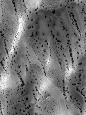
"Not Vegetation!
Defrosting Sand Dunes in Late Southern Winter "
http://Mars.jpl.nasa.gov/mgs/msss/camera/images/dune_defrost_6_2001/
Thus proclaimed the banner headline at the MSSS site after anomalists on Mars Internet message boards began to refer these as the "Dalmatian Spots " several years ago. The JPL/MSSS consortium quickly moved to quell such irritating talk on the Internet with one of there historically documented spin doctoring jobs, publishing a site to refute such spurious contentions.
To quote the good geologists and planetary scientists at Malin Space Science Systems:
"Despite the "sensation" one gets when looking at pictures of spotted, defrosting Martian dunes (i.e., the sensation that these images show some form of life, like vegetation, growing on Mars) these features are a normal, common manifestation of the springtime defrosting process on Mars. The ices involved--because of the low temperatures at these locations--are probably both frozen water and carbon dioxide, though it is unclear as to whether one type of ice dominates over the other in controlling the appearance and coalescence of the dark spots. It is known from the first Martian year of MOC operations that by summer all of the frost--and thus all of the spots--on the dunes will be gone."
Lowell would have scoffed and replied, "Good sir, it's obvious the growing season has ended".
Hungarian Scientists, however seemed to
side with with the common sense of the anomaly community and had the audacity
to publish a white paper claiming this was indeed some type of biological growth.
It can be found at http://www.lpi.usra.edu/meetings/lpsc2001/pdf/1543.pdf .
The Hungarians, as well, are engaged in a struggle for funding. They hope to
get some.
Nafud, Saudi Arabia in color
Here we see a a satellite image of modern
pivot-point irrigation in the Nafud, Saudi Arabia region. One can easily note
the lovely green color the irrigated patches of desert. Upon comparison of greyscale
images from Earth and Mars they would seem to represent similar phenomenon,
namely some form of vegetation. Below we see the
"Dalmatian Spots " at 4 m/pixel resolution (left) compared to the
Nafud region (right) at 5m/pixel resolution.
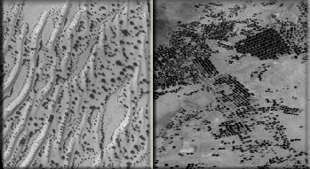
Martian spots compared to pivot point irrigation in the desert.
Finding extraterrestrial life would provide
the impetus for the opening of the New Frontier. Mars aficionados may be correct
in their estimate that disclosure is imminent. The Europeans may well come out
and state that they have found indications of extraterrestrial life on Mars
after the ESA Mars Express probe commences it's primary science mission of collecting
substantial data on and below the surface of Mars. If so, NASA will look rather
duplicitous given it's historical record on such issues.
While not wholly proposing a sprinkler
system in the southern latitudes of Mars, this author can certainly note a striking
similarity between these images.
Vegetation seems a more likely hypothesis as opposed to one
of those extremely versatile defrosting Martian sand dunes. Surely all the wonders
of Mars cannot be attributed to mere sand dunes?
Numerous highly publicized images from the
south polar region of Mars appear to show "trees" at various points
during the Martian year. These "banyan" like anomalies that stretch
for kilometers fall within what Lowell referred to as a "dark band"
he observed moving along the south polar region as the ice cap retreated during
the 1894 opposition. Malin Space Science Systems, surprisingly enough, states
these images show "defrosting dunes near the south polar cap of Mars".
Well, that certainly explains why they look nothing like the defrosting sand
dunes of the Dalmatian spots. Upon viewing this Martian Mega-Fauna one ponders
if they are deciduous or coniferous in nature and if they have leaves which
change colors in the autumn. New ESA color images will most likely show these
to be some type of vegetation.
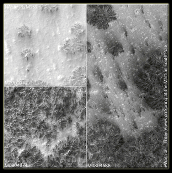
Martian southern polar "trees"
during different seasons
Image Courtesy of Kurt Jonach
How can unbiased researchers compare images so dissimilar as Martian "Seeps", the "glass tunnels", the "Dalmatian spots" and the "mega-trees", which bear no resemblance to one another at all, claim they all represent same phenomenon, namely a sand dune? You'd think that with a string of degrees as long as their arms these fellows could be a tad bit more imaginative.
To this author, these treelike anomalies and the Dalmatian spots are more readily recognized as vegetation than as a pile of sand.
As a matter of historical record, the most interesting of Martian imagery has time and time again been relegated to obscurity with this standard appellation of ignominy from JPL and MSSS. Drs. Malin, Edgett and Pieri would have us believe that all things Mars are made of sand. At this point it certainly looks like Schiaparelli's "Gemination" is a more plausible explanation for these images from Mars which seem to indicate various forms of plant life growing around the orb, waiting to burst forth into bloom after being exposed to the proper Martian stimulus.
As for our tunnels, we know Acidalia Planitia ranks high in data collection priority for all instrument packages due to the high number images taken there. The real question is if there is such an interest by NASA in this area-what is it? The relationship between these recurring sets of surface structures and "landscape art" anomalies begs further inquiry from the planetary science community. Like Lowell and Schiaparelli before him, we choose to believe our own eyes above the dissenting platitudes of Mars pundits.
Taken individually, none of these suppositions "constitutes proof". Considered additively, they do serve to constitute what one could term "reasonable doubt" in the jury of public opinion with regards to the quality of research NASA is conducting by summarily dismissing these highly unusual surface features on the surface of Mars as simple sand dunes or tricks of "light and shadow".
"All
this, of course, may be a set of coincidences, signifying nothing; but the probability
points the other way.
As to details of explanation, any we may adopt will undoubtedly be found, on
closer acquaintance, to vary from the actual Martian state of things; for any
Martian life must differ markedly from our own. Conditions
hold there which would necessitate a much more artificial state of things, ...largely
dependent upon a system of irrigation, and therefore much more systematic than
any we have as yet been forced to adopt."
-Percival Lowell
Coincidental or not, this interesting topic of debate merits further study. In the next section we discuss the another repeating "class" of objects from Mars. Surface intaglios and effigies that seem to be variations on a continuing theme being illustrated on the surface of Mars. Does continuity of theme constitute proof? Is the circumstantial evidence pointing to a relationship between geophysical data, "landscape art" and other Martian anomalies strong enough to warrant serious investigation?
You be the judge.