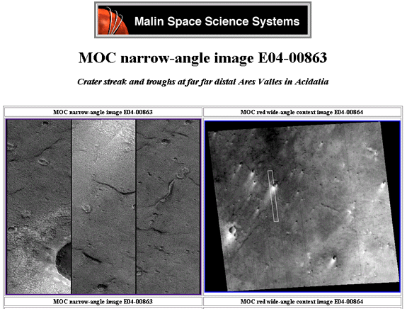
Lowell's Legacy- Part 5 - MOC Image E04-00863 Crater streak and troughs at far far distal Ares Valles in Acidalia
"Each phenomenon is highly suggestive considered alone, but each acquires still greater significance from its association with the other; for here in the oases we have an end and object for the existence of canals, and the most natural one in the world, namely, that the canals are constructed for the express purpose of fertilizing the oases. Thus the mysterious rendezvousing of the canals at these special points is at once explicable. The canals rendezvous so entirely in defiance of the doctrine of chances because they were constructed to that end. They are not purely natural developments, but cases of assisted nature, just as they look to be at first sight. This, at least, is the only explanation that fully accounts for the facts."
-Percival Lowell
Once again we return to Acidalia
Planitia where orbital image strip MOC E0400863 reveals another amazing local
system of Lowell's "canals", analogous to the tunnel complex analyzed
in Mars Global Surveyor Orbit M15-01228, The annotated
"Big Picture" which included the "crater domes" along with
an assortment of convex crater anomalies and an apparent entrance to the tunnel
system, our so called "Johnny Danger's Grand Central Station" with
it's "Oannes" effigy. Here, situated cozily near to
Lowell's "canals" we once again find a series of large surface structures,
apparent surface entrances to the tunnel system. A number of highly unusual
"craters" are found in the vicinity. These appear to have some type
of structures or tiers attached to their sides which overhang the crater bowls
like a balcony. These internal crater structures have anthropomorphic characteristics
that suggest they are artificial constructs of intelligent design. There also
appears to be standing liquid water just below. The most likely source of it
is our canals.
Image Credit: NASA/JPL/MSSS
Allow us to call your attention to the presentation of this area by MSSS. Rather than presenting this in strip format as is the norm, the image is tiled and poorly processed in the same manner as M15-01228 (detailed in part 6). After perusing numerous images from Acidalia that show clear indication of the "glass tunnels" we have determined that only E04-00863 and M15-01228 have been presented with this tiled display rather than as a strip.
As a caveat to this, thus far only these two image strips contain what appear to be surface entrances to the tunnel system and feature what are clearly large scale works of landscape art or effigies. How can this be a coincidence? MSSS has scrutinized every single image that MGS has acquired. It becomes obvious that someone looked at these two particular images with such large, well defined surface anomalies and made a conscious decision to present them as poorly as possible to limit the amount of attention these images elicit upon first glance. While hardly censorship or a blatant cover-up, it does serve to illustrate that someone in charge at MSSS has determined that these two images are somehow different from the rest and wished to limit discussion on them. What possible service could this render for the American citizen who funds these endeavors? It makes one wonder again about the possibility that all the data loss areas (blacked out) in MOC camera images have been intentionally introduced during some internal review at MSSS. (Who knows, perhaps the principle investigators are co-authoring a book and witholding the most astounding images for themselves.)
After reasonable enhancement of the image even the casual viewer can determine that these "glass tunnels" clearly connect with these surface openings, providing us with spectacular imagery. Whether they are artificially constructed or produced by some unknown Martian geological processes remains to be seen. Only further high resolution images and a field trip to Mars can settle this issue. Regardless of their origin, there are numerous astounding surface features found in this particular image strip.
"They are not purely natural developments, but cases of assisted nature, just as they look to be at first sight."
Notable modern Mars pundits have gone as far as to suggest a similar notion in that these glass tunnel anomalies may be some type of bio-constructs due to their peculiarly organic look. Proponents of such theories had best credit Lowell with this idea as he suggested it and committed the idea to paper long before they were born. So much for original thinking and the rush to grab the glory of being the first to publicize some new idea about Mars. Percival Lowell beat us all to it.
Starting at the top of the strip we will travel south along Lowell's canals, examining crops taken from some unusual places along the way. We would like to note that the first two items you will inspect were the last to be analyzed. They represent small areas of the image strip that while within the limits of resolution did require a substantial magnification to annotate adequately. It was only after viewing the much larger structures further south down the canal system and theorizing how the system might work that I deemed these features worthy of further sctutiny. The effort was certainly worth it. Both of the first two areas would make excellent candidates for the Mars Reconnaissance Orbiter's high resolution camera in 2005.
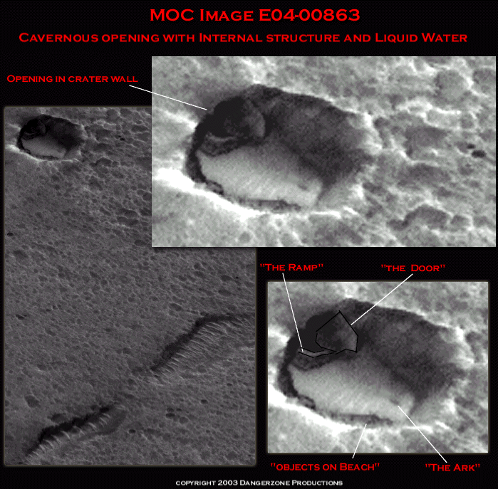
In the first crop from this image strip (E0400863) is an object I can only describe as "looking like something from a science fiction movie"(or possibly "The Lord of the Rings"). In terms of scope when compared to the entire image strip which measures 3.14 km wide by 37.02 km long this tiny little pockmark is near one corner of the very top and hardly justifies a second glance when one is busy tunnel surfing with Lowell.
Ironically, it is one of the more intriguing images in terms of it's mechanical engineering nature and systemic relationship to the tunnel system. If one assumes that this is a closed system of plumbing beneath the surface of Mars, then it is appropriate to assume that this system would require some one way valves or "check" valves to insure that the stuff you want to get out does and no undesirables get in. Similar in function to the one way artificial heart valves now in use. It opens outward but not inward.
Shown below is what appears to be a large
barrier or bulkhead about 70m meters tall, designed to swing around and seal
off the aperture behind it. It would pivot around a central point, swinging
out to overhang the old fishing hole. A ramp like causeway can be seen running
down to the lake, which is around 200 meters across. The edge of the door overhanging
the water even has a notch cut in it for relief, so as it can clear the inclined
ramp when it swings shut.
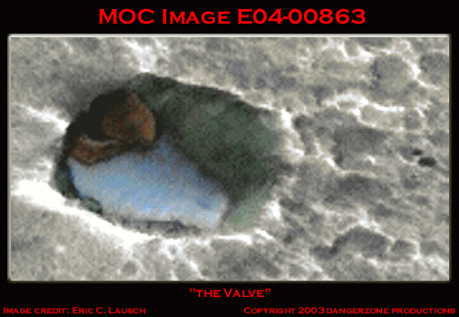
Bearing a striking resemblance to the butterfly valve what one would see atop an old single barrel carburetor, we struggled to quantify this artifact. As Johnny Danger's Giant Alien Mega-Valve seemed somewhat grandiose, I simply refer to this little beauty as "The Valve".
The Valve
MOC Image E0400863
Image courtesy Eric C. Lausch
©2003 Dangerzone Productions
"A very slight hint from the eye goes a long way in the brain of the one; no distance at all in the brain of the other."
-Percival Lowell
What originally drew us to this area was the dark spot on the lake we have termed the"Ark". It looked woefully out of place. Surprisingly enough, such a small speck stood out like the proverbial sore thumb when perusing the massive image strip. What the heck is that? A Mega-Dolphin? Floating debris? An alien canoe nearing landfall as it passes from beneath the shadow of the cliff face that borders the lake? There appear to be several other similar small objects on the shoreline at about six o'clock along the crater, like logs washed up along Puget Sound. This location would prove an excellent candidate for the high resolution camera bound for Mars in 2005 on the Mars Reconnaissance Orbiter. That such a small , easily overlooked area would prove so interesting is testimony to how many more surprises await us on Mars. It also makes you wonder again about what all the data dropouts in various MOC images might have revealed to us.
Lowell of course, would have suggested that
these were Martian tunnel dwellers out for a relaxing day of fishing and volleyball
at their favorite fishing hole. Rumor has it that Mars had the best seafood
in the solar system at one time.
The Valve
MOC Image E0400863
Image courtesy Eric C. Lausch
©2003 Dangerzone Productions
As a caveat to this, there are several other
structures in image strip E0400863 that have openings approximately the same
size as the one pictured here. These areas were analyzed prior to the "valve".
Directly adjacent to these openings one can see objects jutting out from the
openings, perpendicularly, as does the "valve". They are approximately
the same size as the "valve".
However due to the sun angle of this image strip, all subsequently analyzed
openings are for the most part are positioned north east (facing southwest)
and are in shadow, preventing us from discerning their internal details. The
"valve" and "ramp" however, are located to the north west
side of the basin or crater it resides in and is illuminated by the sun. Thus
we can surmise it's true geometry and theorize on its nature. Other similar
items we must leave for conjecture or later analysis after high resolution images
are taken.
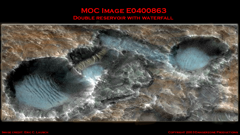
Southward bound we next see a set of twin
craters or "basins" that are apparently connected by a subterranean
tunnel. We theorize that water is provided from an underground source, travels
down the grade to the lower elevations and then plunges over edge in to the
basins below. The water is then returned to beneath the surface thorough the
large tunnel openings back into the underground aquifer. This could possibly
be a method to aerate or purify the water before recycling it back into the
system. The larger of the two lakes is about 250 meters across, about the same
size as medium sized reservoir found in a state park. To some this analysis
will seem a stretch at best. Lakes and waterfalls on Mars! Hopefully, after
examining the entire image strip they will reconsider their position.
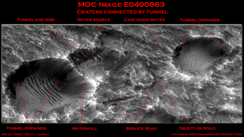
Craters connected by subterranean tunnel
MOC Image E0400863
Image courtesy Eric C. Lausch
©2003 Dangerzone Productions
Adding a splash of color to our image proves enlightening. The ribs of the tunnel connecting the craters can easily be resolved in this image, their distinctive banding making them so recognizable. Water can be seen pooling alongside the tunnel in the middle tier of the system prior to plunging into the larger basin and returning below. As for our proposed "service road" there does appear to be a relatively clear path that starts between the basins that appears to narrow as it snakes down along the larger basins rim like some Martian country road. As to the nature of the bright "object" seen on this path one can only conjecture and so we will leave this to the readers imagination.
Double Reservoir
Image courtesy Eric C. Lausch
©2003 Dangerzone Productions
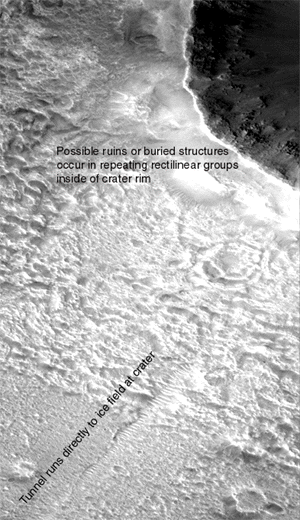
Now we go from scrutinizing relatively small areas to viewing a substantial swath of the overall image strip. The majority of our remaining stops feature structures on a much larger scale than seen in our first two crops. Traveling south we see the canal system running directly through an ice field to a large crater (numerous tubes are visible under the ice field in the full sized image strip), precisely as Lowell documented in his hub and spoke system. Just inside the rim of the crater there is a conglomeration of what appear to be groupings of ruined structures in rectilinear patterns, nestled like some quaint seaside village or marina situated on a long forgotten lake that once filled the crater basin. Exactly the kind of place a fellow like Percival Lowell could have retired to, opening up a T-shirt shop and running charters from the pier carrying tourists out to experience an epiphany as they "Swim with the Mega-Dolphins".
Crop of E0400863
Image courtesy Eric C. Lausch
©2003 Dangerzone Productions
Zooming in on an area inside the
crater brings us to see regular patterns somewhat reminiscent of terrestrial
city streets lined with buildings. Some will attribute linearity and blockiness
to imaging artifacts introduced from enlargement algorithm. However, one can
still easily discern the patterns in the full sized NASA image without any enhancement.
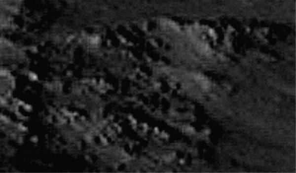
Rectilinear patterns of ruins in crater
Image courtesy Eric C. Lausch
MOC Image E0400863
"The disk is simply a network of such intersections. Sometimes a canal goes only from one intersection to another; more commonly it starts with right of continuation, and, after reaching the first rendezvous, goes on in unchanged course to several more."
-Percival Lowell
Crop of E0400863
Image courtesy Eric C. Lausch
©2003 Dangerzone Productions
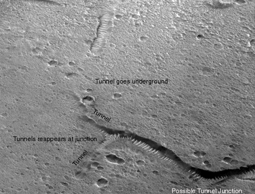
Lowell could be describing this very image. Heading south down the tube from the ice fields and crater, our tunnel goes underground only to emerge at another junction where two more tributaries branch off just as Lowell recounts, leading onward to additional inexplicable surface features on Mars.
Interestingly enough, an inverted image
of this junction appears to show two tunnel ribs that cross perpendicularly
forming an "X" at the midpoint of the intersection. The folks at JPL
and MSSS will most likely deduce that this is merely a crescent shaped "barchan
dune" which are known for their characteristic of passing through one another
while still maintaining shape.
"Elementary, my dear Lowell!"
Inverted image of tunnel junction
Image courtesy Danger Team Image Labs
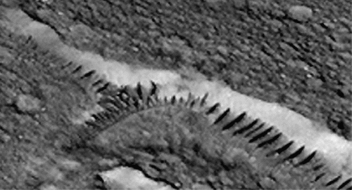
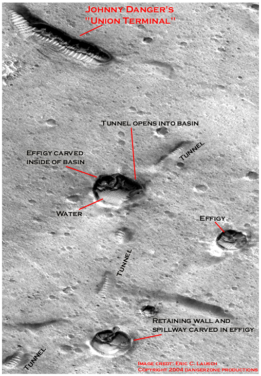
In addition to these surface ruins, a little further down the image strip, we once again are confronted with highly unusual, immense structures which, like those in M15-01228, appear to allow egress to the Martian tunnel system, albeit without the "Oannes" effigy type adornment that we analyzed earlier. Once again we begin to see what can termed a "class" of objects apparently of similar form and function. Several smaller entrances, like maintenance bays or scenic lookouts can also be seen opening onto the surface as the canals of Mars slither along under the regolith from opening to opening.
One immense structure dominates this section of tunnel system. We call it Johnny Danger's "Union Terminal".
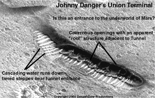
Johnny Danger's Union Terminal
MOC Image E0400863
Image courtesy Eric C. Lausch
©2003 Dangerzone Productions
While considerably smaller than "Grand Central"
(M15-01228), at 3.06m/pixel the structure itself appears to be around 110 meters
in height and 830 meters in length (well over a kilometer if the tunnel ribs
are included). The large openings on the second tier are approximately 75 meters
high. About one-third of the way from the right end one can see another bulkhead
jutting out, similar to the "valve". Aside from being an access point
( which we feel confident is Grand Central's main purpose given the presence
of the "Oannes" effigy), this may be another in a series of water
reclamation/filtration/aeration facilities dedicated to the ongoing systemic
well being of the ecosystem. Biological scrubbers, so to speak.
Of course, if you're able to entertain that sort of notion, the next obvious
question becomes for whom or what?
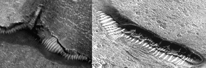
Comparison of tunnel entrances
at E0400863 and M15-01228
Image courtesy J. Danger & Eric C. Lausch
No speculation is necessary about Percival Lowell's opinion on this:
"Irrigation, unscientifically conducted, would not give us such truly wonderful mathematical fitness . . . A mind of no mean order would seem to have presided over the system we see - a mind certainly of considerably more comprehensiveness than that which presides over the various departments of our own public works. Party politics, at all events, have no part in them; for the system is planet-wide . . ."
-Percival Lowell
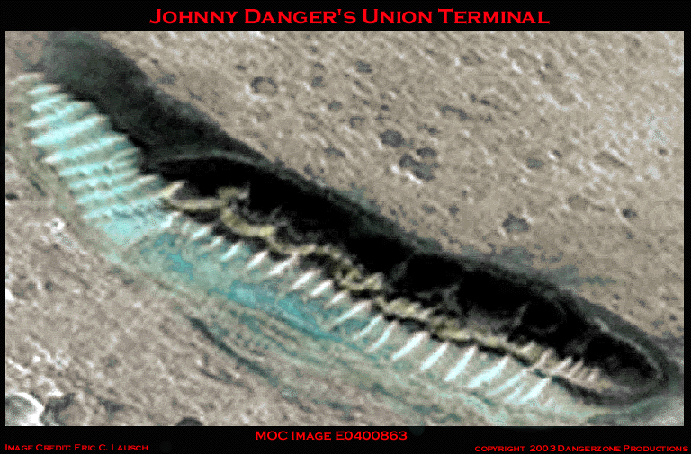
Johnny Danger's Union Terminal
MOC Image E0400863
Image courtesy Eric C. Lausch
©2003 Dangerzone Productions
Scoot back about a meter and look at the image above for a few seconds.
This is an actual image from Mars with some color added! This edifice is almost a kilometer across and a hundred meters high! Just what do you think this is? A Sand dune? I'd love to hear Giovanni Schiaparelli and Eugene Antonaudi sound off on this! I bet they'd end up coming to blows if you got them together in a room with Percival Lowell and Michael Malin!
Isn't it entertaining that nineteenth century astronomers had greater insight into the nature of the universe than do the collective minds of NASA, JPL and MSSS? We can only look forward to hearing the ESA's opinion on these apparently artificial constructs in the near future. One can only wonder why the learned scientists at MSSS and JPL seem to have no curiosity or inclination to further investigate and categorize these highly unusual areas on the planet Mars, rather than simply dismissing the majority of Martian anomalies as some type of highly versatile sand dune. The U.S. taxpayer is not well served by this lack of scientific curiosity. Several smaller entrances, like maintenance bays or scenic lookouts can also be found nearby in addition to the unusual craters shown below.
As one peruses these images perhaps it is appropriate to question once again the oft stated hypothesis that pareidolia is the culprit and only the explanation for these images. Well, pareidolia or a sand dune.
In this image crop from E0400863 to many a casual observer ( I asked!) there appear to be large faces, not unlike a some Martian Kitty Kat poking it's nose out from a comfy den under the surface. The crop itself measures 1.5 kilometers by 2.2 kilometers. These effigies, like those on the plains of Nazca they are best viewed from above. One might imagine the likes of John Carter venturing into the underground lair, teeming with denizens of the Martian zoo (or possibly a Martian "cathouse" staffed with Martian sex kittens:).
Are these further examples of Martian landscape
art or the result of some stratification process relative to the local geology?
The rich limestone and other aquifer materials found in the northern lowlands
of Mars could only be so elegantly carved by two forces in nature. Intelligence
or water. The presence of both on Mars had been espoused of by Lowell prior
to the turn of the twentieth century.
The Martian Mega Kitties
Crop of E0400863
Image courtesy Eric C. Lausch
©2003 Dangerzone Productions
These three reservoirs or "basins" may in fact be holding tanks that form the perimeter for an underground reservoir supporting a this area via the glass tunnel phenomenon. The ESA's Marsis ground penetrating radar should resolve this issue and verify the presence of underground tunnels expeditiously if directed at this area of Mars.
Once again I invite you to take part in Johnny Danger's Dangerous Martian Rorschach test!
Scoot back about three feet from your monitor (Yes! You really have to do this!) and gaze at the next image. Get back far enough so that all the pixelization smoothes out. Just what the hell is that? Some Martian mega-Marsupial carved in effigy? Stratified Martian limestone? Another sand dune perhaps?
And how about those eyes?
Crop of E0400863
Images courtesy Danger Team Image Labs
©2003 Dangerzone Productions
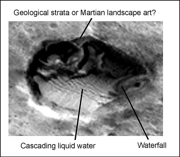
Now that your eyes have grown accustomed to the Martian lighting-take another look at this same area. scootch right up there and put you nose about twelve inches from the screen. This effigy towers 145 meters above the pool. It is interesting to note that the "ears" and waterfall cast shadows consistent with the sun angle for the spacecraft ancillary data.
Crop of E0400863
Images courtesy Eric C. Lausch
©2003 Dangerzone Productions
Now that's art!
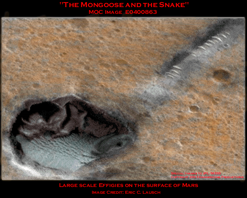
Once again we see indications of large scale works of art on the surface of our sister planet. As if taken from a scene in some Martian Rudyard Kipling novel, a gigantic snakes head emerges from the area near the tunnel opening while some large predator crouches beneath the overhanging roof on the opposite side of the crater. We, for our part, will happily accept pareidolia, alien effigy or even a sand dune as a happy alternative to giant alien Mega-snakes residing beneath the surface of Mars. If such creatures exist, I'd recommend bypassing Mars on your next vacation.
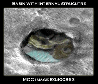
The second, smaller crater of the group push the limits of resolution for our purposes. Several individuals have reported seeing the face of a feline and the head of some type of rodent to its left. While we cannot say exactly what this represents, there is clearly some structure attached to the crater rim, extending out to overhang the floor by some distance.
Crop of E0400863
Images courtesy Eric C. Lausch
©2003 Dangerzone Productions
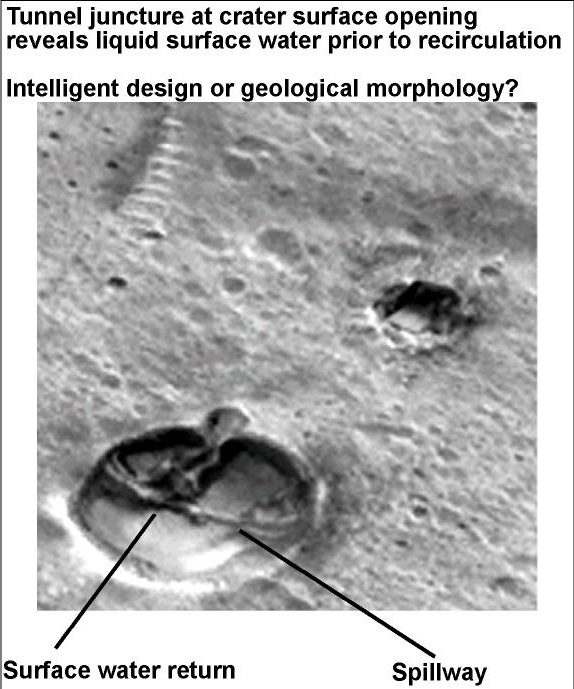
Our third basin (tunnel/surface opening) in this general vicinity shows what appears to be a spillway and surface water return . A ramp of sorts can be seen running from about one o'clock on the crater rim to the overhanging structure below. Once again, we ask that you sit back from your monitor to peruse this image.
Crop of E0400863
Images courtesy Danger Team Image Labs
©2003 Dangerzone Productions
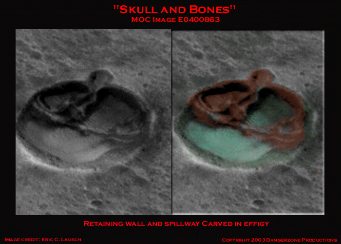
Numerous individuals (most of whom know
little of Mars) report seeing a skull and skeletal right arm, complete with
opposing thumb and digits in the structure that forms the spillway. Arcing round
from the left to form the rear wall of the enclosure is the left arm and hand
that intertwines with the right to form a "hollow" between the thumb
and fingers as when you or I clasp hands on the table.
Crop of E0400863
Image courtesy Eric C. Lausch
©2003 Dangerzone Productions
I can see it. Can you?
Is this another case of Martian pareidolia or just one of the many examples
of large scale effigies or intaglios dotting the Martian landscape? We can only
hope the NASA and the ESA will investigate this area in detail.
These images are intriguing in that once again we observe a relationship between various distinct "classes" of interrelated objects associated with the "Glass Tunnel" anomalies. The tunnels themselves, the domes, liquid water , conventional building type surface structures and some type of landscape art or effigy. Over and over again we see inexplicable surface features repeated in the area of Lowell's canals.
"Of course all such evidence of design may be purely fortuitous, with about as much probability, as it has happily been put, as that a chance collection of numbers should take the form of the multiplication table."
-Percival Lowell
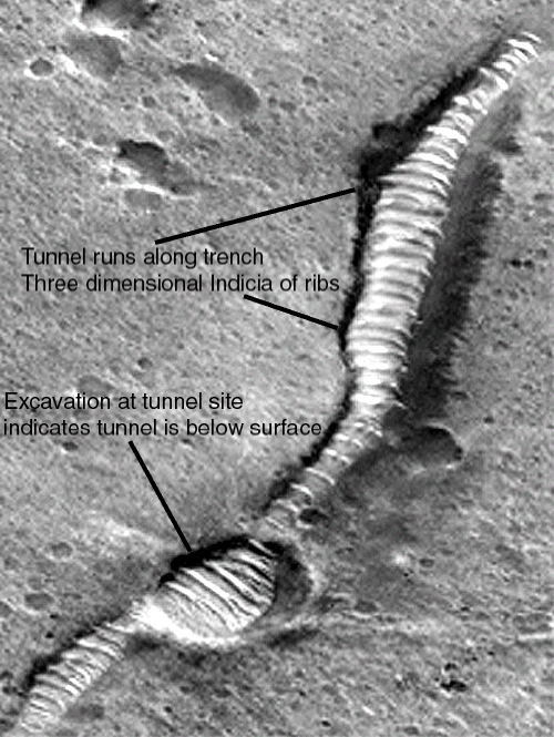
Venturing further along this particular
section of Percival's canals we see something that I cannot ascribe to anything
other than a surface excavation of some type. What geological process can be
attributed to creating this "pit"? One could postulate a meteor
strike, this however leads one to conclude this removal of surface material
has exposed
a subsurface structure. It would follow then that whatever was uncovered was
tough enough to survive a speeding meteorite impact. Personally, we doubt
that
this surface material removal was caused by a meteor. A closer look at this
tunnel section reveals the three dimensional nature of the load bearing
supports or
"ribs". Also, one can easily discern the slopes of the defile or
creek bed in this image. This "excavation" clearly shows a large
diameter structure beneath the surface of Mars. Perhaps it's an underground
sand dune?
Or perhaps not.
Crop of E0400863
Image courtesy Eric C. Lausch
©2003 Dangerzone Productions
Our tube can be seen running along a channel akin to a terrestrial creek bed, the exposed top narrowing along its length. However, at the location of the excavation, one can clearly see that this is a construct of much larger diameter below the surface based on what we see exposed along the channel. Explain this as a sand dune! This is obviously something under the ground boys and girls.
Further down the tube past the excavated
area is another surface opening sporting what appears to be a spillway with
cascading water. Just below a larger opening that we've dubbed the Lowell Tunnel
entrance, similar in nature but smaller than Union Terminal (but without any
apparent liquid water) can be seen as the tunnel once again disappears beneath
the surface of Mars.
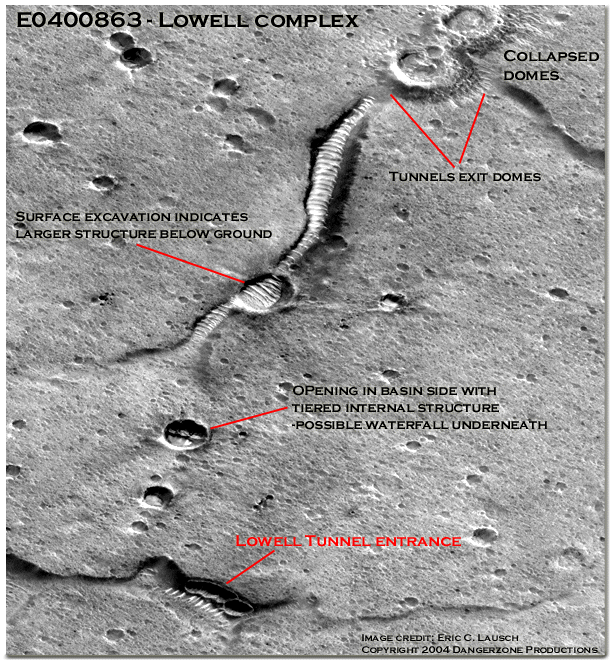
Crop of E0400863
Image courtesy Eric C. Lausch
©2004 Dangerzone Productions
This crop of the Lowell Tunnel Complex measure 1.8 kilometers by 2.0 kilometers. Why do the planetary scientists at JPL and MSSS continue to classify these seemingly artificial constructs as Martian dune trains when so many images refute this position? At the very least they should be a hot topic of discussion in graduate classes in exo-geology. Is the quest for government funding so circumspect in regards to mainstream credibility that dares not even speculate on such issues? One could more likely surmise the theories of Lowell and Schiaparelli on these images than guess what fanciful explanation mainstream planetary science would bring to the table with regards to this subject. (US Taxpayers please insert sand dune here!)
The possibility remains that this is part of the planetary system documented by Lowell and Schiaparelli in the nineteenth century. A system that was subsequently buried by some global sandstorm or other mechanism before the mid twentieth century when Antonaudi reported he could no longer discern the markings, which had grown fainter since at each opposition after 1900.
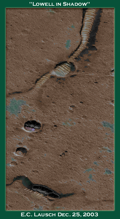
"Lowell in Shadow"
Image courtesy Eric C. Lausch
©2003 Dangerzone Productions
In the basin just north of the "Lowell"
tunnel entrance one can discern an opening, vertical supports and internal workings
similar to the "valve". Directly beneath, we see what may well be
liquid water plunging from beneath the upper tier before percolating back into
the Martian canal system. The tiered basin is approximately 210 meters wide
by 140 meters high. This would put our waterfall near a height of 45 meters.
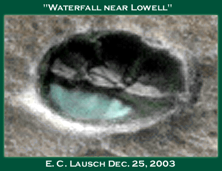
"Waterfall near Lowell"
Image courtesy Eric C. Lausch
©2003 Dangerzone Productions
Below in the original greyscale one can see the astounding detail of these unusual
surface features. Large dark openings with vertical supports can be seen in
both the basin and the "Lowell" entrance. I must admit that upon first
viewing that it had a geological-biological "feel" to it, but after
scrutinizing the other megalithic details in the area it is apparent they are
the product of intelligent intervention.
Perhaps in true Lowellian fashion, "They are not purely natural developments, but cases of assisted nature, just as they look to be at first sight."
The Lowell tunnel opening measures about 240 meters in length by 110 meters high. The openings appear to be almost exactly the same height as do the openings found at the Union Terminal site. Indeed, aside from the difference in scale, these edifices appear to be of strikingly similar design and origin. Once again, we are forced to concede another apparent "class" of objects, surface structures on the planet Mars, the nature of which we can only speculate about. The Lowell facility appears to be bone dry, as opposed to the other structures we've see. Perhaps the basin with the waterfall just north of Lowell acts as some type of diverter or floodgate, which can allow Lowell to become flooded. Or perhaps Lowell is simply an entrance or serves some other purpose at which we can on guess. Whatever this is, it is indicative of the existence of some type of large scale system on Mars and requires urgent study with our latest capabilities.
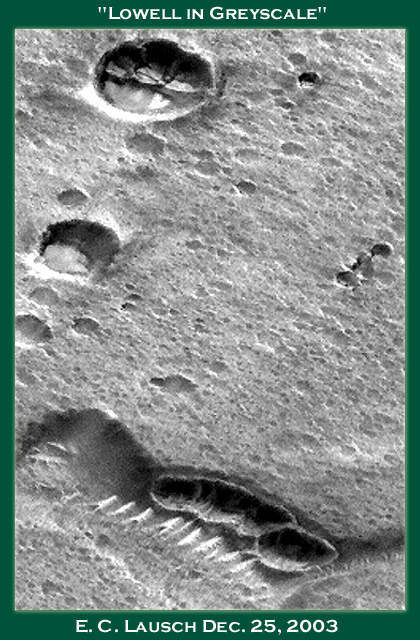
"Lowell in Greyscale"
Image courtesy Eric C. Lausch
©2003 Dangerzone Productions
Lastly, near the bottom of MOC Image strip
E0400863 we find this strikingly beautiful terraced basin. Approximately 300
meters across, this feature has broad, flat ramp curving along the it's eastern
side. An arched structure near twelve o'clock and the ramp appear to both connect
to a series of terraces, which gradually step down to the pool below. One of
our "glass tunnels" can just be made out to the right of the basin.
If this is not the product of intelligent design then Mother Mars could not
have made a more suitable spot for recreation by mere coincidence.

"Terraced basin south of Lowell"
Image courtesy Eric C. Lausch
©2003 Dangerzone Productions
"Schiaparelli supposes the canals to be canals, but of geologic construction. He suggests, however, no explanation of how this is possible; so that the suggestion is not, properly speaking, a theory. That eminent astronomer further says of the idea that they are the work of intelligent beings: "Io mi guardero bene dal combattere questa supposizione, la quale nulla include d'impossibile." (I should carefully refrain from combating this supposition, which involves no impossibility.) In truth, no natural theory has yet been advanced which will explain these lines. Their very aspect is such as to defy natural explanation, and to hint that in them we are regarding something other than the outcome of purely natural causes.
Indeed, such is the first impression upon getting a good view of them. How instant this inference is becomes patent from the way in which drawings of the canals are received by incredulously disposed persons. The straightness of the lines is unhesitatingly attributed to the draughtsman. Now this is a very telling point. For it is a case of the double-edged sword. Accusation of design, if it prove not to be due to the draughtsman, devolves ipso facto upon the canals. "
-Percival Lowell
As at our Cydonia site, Lowell would have the odds of this theory being correct at 300 to 1 as the four interrelated sets of water, the glass tunnel anomalies, surface structures and large scale effigies are all present in this locale. Add in the bonus set of weird craters and call Mr. Lowell's bookie!
How fascinating it would be to discuss these images with the likes of Lowell, Schiaparelli, Green and Lockyear! Alas, as I reckon this will not happen any time soon, it's up to their modern counterparts to pursue these issues. To this modern researcher, these "glass tunnels" represent the few remaining visible indications of an ancient planetary system of intelligent design that was observed by astronomers in the nineteenth century. A system that in some areas are still partially intact and functioning at least on some minimum level of service.
Once again we find a high incidence of local water resources, large scale effigies and surface structures directly adjacent to these tunnel anomalies. However you analyze the equation it portends of intelligent design and all the repercussions of such a epiphany. To those individuals whom as common sense demands, seek answers beyond the practiced official explanations provided by our taxpayer funded government science organizations, one can only hope the coming years of Mars mapping endeavors will yield additional proof in support of these theories and engender a substantive scientific investigation on their behalf.
Lowell wrote detailed accounts
of his Martian studies. In the next section we shall examine additional image
strips in the light of Lowell's descriptions of the canals.
This should prove interesting.